
Cantraydoune


Motte (Medieval)
Site Name Cantraydoune
Classification Motte (Medieval)
Alternative Name(s) Cantray Doune
Canmore ID 14190
Site Number NH74NE 7
NGR NH 7889 4609
Datum OSGB36 - NGR
Permalink http://canmore.org.uk/site/14190


- Council Highland
- Parish Croy And Dalcross (Nairn)
- Former Region Highland
- Former District Nairn
- Former County Nairn
NH74NE 7889 4609.
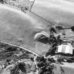
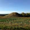
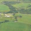
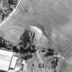
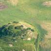
(NH 7889 4609) Motte (NR)
OS 6" map, Inverness-shire, 2nd ed., (1906)
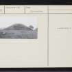
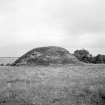
An artificial mound of clay, some 60 to 70ft high and about 200 yards in circumference at base (17 yards circumference on top). It is surrounded on three sides by a low stone wall, and on the E by the Burn of Cantraydoune.
Name Book 1870.
A large earthen mound about 16m high, surrounded by a partially ruined retaining wall, maximum height 1.2m, which is of the latter date. Mr Meldrum considers it to be a motte. (Mr E Meldrum, County Architect's office, Inverness)
Earthworks surveyed at 1:2500.
Visited by OS (NKB) 14 August 1964.
Field Visit (18 August 1943)
This site was included within the RCAHMS Emergency Survey (1942-3), an unpublished rescue project. Site descriptions, organised by county, vary from short notes to lengthy and full descriptions and are available to view online with contemporary sketches and photographs. The original typescripts, manuscripts, notebooks and photographs can also be consulted in the RCAHMS Search Room.
Information from RCAHMS (GFG) 10 December 2014.
Field Visit (May 1978)
Cantraydoune NH 788 460 NH74NE 7
This sandy mound, which rises about 16m above the face of a natural slope, is probably a motte. No features are visible on the uneven summit or on the flattened area that projects from the N side. A deep groove in the E side may be an old excavation trench. The mound, which has been cleared of trees, is now grass-covered and surrounded by an enclosure wall, apparently of no great age.
RCAHMS 1978, visited May 1978
Transactions of the Inverness Scientific Society and Field Club. i (1875-80), 30; Simpson
and Webster 1972, 183, no. 186

