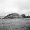
|
Photographs and Off-line Digital Images |
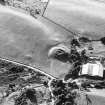
E 08008 |
RCAHMS Aerial Photography |
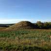
Oblique aerial view centred on the remains of the motte, taken from the ESE. |
2/8/1991 |
Item Level |
|
|
Photographs and Off-line Digital Images |
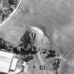
E 08009 |
RCAHMS Aerial Photography |
Oblique aerial view centred on the remains of the motte, taken from the NE. |
2/8/1991 |
Item Level |
|
|
Photographs and Off-line Digital Images |
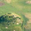
H 92908 CS |
RCAHMS Aerial Photography |
Oblique aerial view centred on the remains of the motte, taken from the SW. |
2/8/1991 |
Item Level |
|
|
Manuscripts |
MS 124/3 |
Records of the Royal Commission on the Ancient and Historical Monuments of Scotland (RCAHMS), Edinbu |
Field notebook No. 2, A Graham (RCAHMS). |
8/8/1942 |
Item Level |
|
 |
Digital Files (Non-image) |
WP 002403 |
Records of the Royal Commission on the Ancient and Historical Monuments of Scotland (RCAHMS), Edinbu |
Scanned copy of RCAHMS Emergency Survey: Manuscripts (1943 Volume 2). |
1943 |
Item Level |
|
 |
Digital Files (Non-image) |
WP 002412 |
Records of the Royal Commission on the Ancient and Historical Monuments of Scotland (RCAHMS), Edinbu |
RCAHMS Emergency Survey: Typescripts (Nairn). |
1943 |
Item Level |
|
 |
On-line Digital Images |
DP 171894 |
RCAHMS Field Survey Digital Photography |
General shot. |
11/10/2013 |
Item Level |
|
|
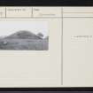
Photographs and Off-line Digital Images |
N 7 |
Records of the Royal Commission on the Ancient and Historical Monuments of Scotland (RCAHMS), Edinbu |
General shot, Cantraydoune. |
18/8/1943 |
Item Level |
|
 |
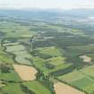
On-line Digital Images |
DP 191401 |
RCAHMS Aerial Photography Digital |
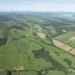
General oblique aerial view along the River Nairn towards Culloden Moor and Clava with Inverness in the distance, looking WSW. |
18/6/2014 |
Item Level |
|
 |
On-line Digital Images |
DP 191402 |
RCAHMS Aerial Photography Digital |
General oblique aerial view along the River Nairn towards Culloden Moor and Clava with Inverness in the distance, looking WSW. |
18/6/2014 |
Item Level |
|
 |
On-line Digital Images |
SC 1432298 |
Records of the Royal Commission on the Ancient and Historical Monuments of Scotland (RCAHMS), Edinbu |
General shot, Cantraydoune. |
18/8/1943 |
Item Level |
|
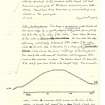 |
On-line Digital Images |
SC 1453975 |
Records of the Royal Commission on the Ancient and Historical Monuments of Scotland (RCAHMS), Edinbu |
Sketch section of Cantraydoune (extract from manuscript) |
18/8/1943 |
Item Level |
|
|
Manuscripts |
MS 36/275 |
Records of the Royal Commission on the Ancient and Historical Monuments of Scotland (RCAHMS), Edinbu |
RCAHMS Emergency Survey; manuscripts 1943 (vol.2) |
1943 |
Item Level |
|
|
Photographs and Off-line Digital Images |
J 11890 CS |
Papers of Professor Geraint Dyfed Barri Jones, archaeologist, Manchester, England |
General view |
1987 |
Item Level |
|
 |
On-line Digital Images |
SC 1551988 |
Papers of Professor Geraint Dyfed Barri Jones, archaeologist, Manchester, England |
Oblique aerial view |
1987 |
Item Level |
|
 |
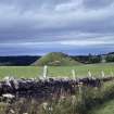
On-line Digital Images |
SC 1696190 |
RCAHMS Aerial Photography |
Oblique aerial view centred on the remains of the motte, taken from the ESE. |
2/8/1991 |
Item Level |
|
 |
On-line Digital Images |
SC 1696191 |
RCAHMS Aerial Photography |
Oblique aerial view centred on the remains of the motte, taken from the NE. |
2/8/1991 |
Item Level |
|
 |
On-line Digital Images |
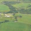
DP 340666 |
Papers of James Sloan Bone, landscape historian, Inverness, Highland, Scotland |
Oblique aerial view of Cantraydoune Motte, in the lower Nairn valley, looking S. |
19/7/2006 |
Item Level |
|
 |
On-line Digital Images |
DP 342222 |
Papers of James Sloan Bone, landscape historian, Inverness, Highland, Scotland |
Aerial view of Cantraydoune Motte, part of Culloden Forest, near Croy, E of Inverness, looking N. |
20/7/2010 |
Item Level |
|
 |
Digital Files (Non-image) |
WP 007514 |
Publications by the Royal Commission on the Ancient and Historical Monuments of Scotland |
(5) The Archaeological Sites and Monuments of Nairn District |
9/1978 |
Item Level |
|
 |
On-line Digital Images |
SC 2365601 |
Records of the Ordnance Survey, Southampton, Hampshire, England |
Cantraydoune, NH74NE 7, Ordnance Survey index card, page number 1, Recto |
1958 |
Item Level |
|
 |
On-line Digital Images |
SC 2365602 |
Records of the Ordnance Survey, Southampton, Hampshire, England |
Cantraydoune, NH74NE 7, Ordnance Survey index card, page number 2, Verso |
1958 |
Item Level |
|
 |
On-line Digital Images |
SC 2365603 |
Records of the Ordnance Survey, Southampton, Hampshire, England |
Cantraydoune, NH74NE 7, Ordnance Survey index card, Recto |
1958 |
Item Level |
|
|
All Other |
551 166/1/1 |
Records of the Ordnance Survey, Southampton, Hampshire, England |
Archaeological site card index ('495' cards) |
1947 |
Sub-Group Level |
|


