
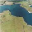
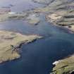
Sanday, Camas An Ail, Cottages And Boatshed


Boathouse (Period Unassigned), Building (Period Unassigned), Cottage(S) (Period Unassigned)
Site Name Sanday, Camas An Ail, Cottages And Boatshed
Classification Boathouse (Period Unassigned), Building (Period Unassigned), Cottage(S) (Period Unassigned)
Alternative Name(s) Canna Harbour; Point House
Canmore ID 137782
Site Number NG20SE 70
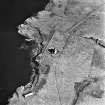
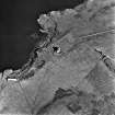
NGR NG 2745 0490
NGR Description NG 2745 0490 and NG 2747 0489
Datum OSGB36 - NGR
Permalink http://canmore.org.uk/site/137782


- Council Highland
- Parish Small Isles
- Former Region Highland
- Former District Lochaber
- Former County Inverness-shire
NG20SE 70 2745 0490 and 2747 0489
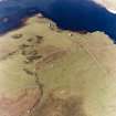
Two semi-detached cottages and a boatshed are situated above the bay opposite the pier in Canna Harbour. The cottages (NG 2745 0490) have mortared rubble walls and share a corrugated iron roof, and there is a garden to the rear and a terrace to the front. The boatshed (NG 2747 0489) lies about 12m to the E and is open on its seaward, E, side. Although now roofless, it too has mortared rubble walls, and it measures 7.8m from ENE to WSW by 6.5m transversely overall; a high-level window is visible in its W end.
An unroofed rectangular building is depicted at roughly this location on the 1st edition of the OS 6-inch map (Argyllshire, 1881, sheet lix), but cannot be reconciled with the features surviving today.
(Canna 77-8).
Visited by RCAHMS (ARG, IMS), 30 April 1994.
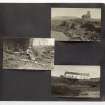
NG 2745 0490 An archaeological survey and small-scale excavation was conducted at the site of Point House, Sanday, Canna, in September 1998. The work was conducted in advance of conversion to accommodation. The nearby St Edward's Church (NG20SE 25) was also to be affected by the development, and was also surveyed.
Point House is a 19th-century rectangular domestic structure, comprising two separate buildings with a shared gable. The church was erected between 1885-89, and is currently in a state of disrepair.
The survey and excavation at Point House has elucidated the developmental sequence, with the southerly component originally being a free-standing structure. The N building was added, both structures apparently serving as domiciles for a period thereafter. Porch abutments were later added, and the roof replaced. The southern building was then abandoned, and turned over to use as a byre, while the northern building continued in use until relatively recently.
The church is to undergo alterations which are wholly reversible, and the interior fabric was drawn, photographed and recorded prior to the commencement of the work.
Sponsor: National Trust for Scotland
A Dunn 1999
Field Visit (30 April 1994)
Two semi-detached cottages and a boatshed are situated above the bay opposite the pier in Canna Harbour. The cottages (NG 2745 0490) have mortared rubble walls and share a corrugated iron roof, and there is a garden to the rear and a terrace to the front. The boatshed (NG 2747 0489) lies about 12m to the E and is open on its seaward, E, side. Although now roofless, it too has mortared rubble walls, and it measures 7.8m from ENE to WSW by 6.5m transversely overall; a high-level window is visible in its W end.
An unroofed rectangular building is depicted at roughly this location on the 1st edition of the OS 6-inch map (Argyllshire, 1881, sheet lix), but cannot be reconciled with the features surviving today.
(Canna 77-8).
Visited by RCAHMS (ARG, IMS), 30 April 1994.
Excavation (5 September 1998 - 12 September 1998)
NG 2745 0490 An archaeological survey and small-scale excavation was conducted at the site of Point House, Sanday, Canna, in September 1998. The work was conducted in advance of conversion to accommodation. The nearby St Edward's Church (NG20SE 25) was also to be affected by the development, and was also surveyed.
Point House is a 19th-century rectangular domestic structure, comprising two separate buildings with a shared gable. The church was erected between 1885-89, and is currently in a state of disrepair.
The survey and excavation at Point House has elucidated the developmental sequence, with the southerly component originally being a free-standing structure. The N building was added, both structures apparently serving as domiciles for a period thereafter. Porch abutments were later added, and the roof replaced. The southern building was then abandoned, and turned over to use as a byre, while the northern building continued in use until relatively recently.
The church is to undergo alterations which are wholly reversible, and the interior fabric was drawn, photographed and recorded prior to the commencement of the work.
A Dunn 1999
Sponsor: National Trust for Scotland
Kirkdale Archaeology

