 |
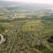
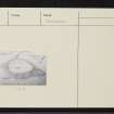
On-line Digital Images |
SC 1864935 |
Papers of James Sloan Bone, landscape historian, Inverness, Highland, Scotland |
Aerial view of Loch Ness, looking SW. |
1992 |
Item Level |
|
 |
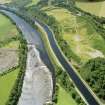
On-line Digital Images |
SC 1865177 |
Papers of James Sloan Bone, landscape historian, Inverness, Highland, Scotland |
An oblique aerial view of the Caledonian Canal and Loch Ness, Inverness, looking SSW. |
1995 |
Item Level |
|
 |
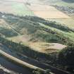
On-line Digital Images |
SC 1903172 |
Papers of James Sloan Bone, landscape historian, Inverness, Highland, Scotland |
Aerial view of Torvean, S of Inverness, looking S. |
1999 |
Item Level |
|
 |
On-line Digital Images |
SC 1944416 |
Papers of James Sloan Bone, landscape historian, Inverness, Highland, Scotland |
Aerial view of Torvean quarry, Inverness, looking W. |
21/8/1999 |
Item Level |
|
 |
Digital Files (Non-image) |
WP 007517 |
Publications by the Royal Commission on the Ancient and Historical Monuments of Scotland |
(8) The Archaeological Sites and Monuments of North-east Inverness, Inverness District |
10/1979 |
Item Level |
|
 |
On-line Digital Images |
SC 2364329 |
Records of the Ordnance Survey, Southampton, Hampshire, England |
Torvean, NH64SW 2, Ordnance Survey index card, Recto |
c. 1958 |
Item Level |
|
 |
On-line Digital Images |
SC 2364330 |
Records of the Ordnance Survey, Southampton, Hampshire, England |
Torvean, NH64SW 2, Ordnance Survey index card, page number 1, Recto |
c. 1958 |
Item Level |
|
 |
On-line Digital Images |
SC 2364331 |
Records of the Ordnance Survey, Southampton, Hampshire, England |
Torvean, NH64SW 2, Ordnance Survey index card, page number 2, Verso |
c. 1958 |
Item Level |
|
 |
On-line Digital Images |
SC 2364332 |
Records of the Ordnance Survey, Southampton, Hampshire, England |
Torvean, NH64SW 2, Ordnance Survey index card, Recto |
c. 1958 |
Item Level |
|
 |
On-line Digital Images |
SC 2364333 |
Records of the Ordnance Survey, Southampton, Hampshire, England |
Torvean, NH64SW 2, Ordnance Survey index card, Recto |
c. 1958 |
Item Level |
|
|
All Other |
551 166/1/1 |
Records of the Ordnance Survey, Southampton, Hampshire, England |
Archaeological site card index ('495' cards) |
1947 |
Sub-Group Level |
|


