
Druidtemple


Chambered Cairn (Neolithic), Stone Circle (Neolithic) - (Bronze Age)
Site Name Druidtemple
Classification Chambered Cairn (Neolithic), Stone Circle (Neolithic) - (Bronze Age)
Alternative Name(s) Leys; Druid Temple Farm
Canmore ID 13505
Site Number NH64SE 23
NGR NH 68512 42013
Datum OSGB36 - NGR
Permalink http://canmore.org.uk/site/13505


- Council Highland
- Parish Inverness And Bona
- Former Region Highland
- Former District Inverness
- Former County Inverness-shire
NH64SE 23 6851 4201
(NH 68514201) Stone Circles [NR]
OS 6" map, Inverness-shire, 2nd ed., (1906).
For nearby trial excavation and watching brief (March 2003), see NH64SE 354.
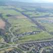
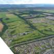
At Druidtemple there is a completely denuded cairn of the Clava Group. The kerb of heavy rounded boulder is almost complete and has a diameter of about 40 feet with twenty-eight stones remaining. The passage runs from the south side and is 19 feet long. When the area of the destroyed chamber was stripped in 1952 (S Piggott 1956) 'it was found that the old surface had been dug over....A few small scraps of cremated bone scattered though this disturbed soil were the only finds made'. The surrounding free-standing circle is about 75 feet in diameter, set 11 to 14 feet outside the kerb. Five stones remain upright and five more are either leaning or fallen. The tallest is to the SW, a large stone 9 feet high.
A cist is said to have been found in the site about 1882. (D Cameron 1882)
D Cameron 1882; S Piggott 1956; F P Lisowski 1956; A S Henshall 1963.
The remains of this cairn stand on a slight elevation
within a tree-clump.
Revised at 1/2500.
Visited by OS (J L D) 23 March 1962.
Scheduled as 'Druid Temple Farm, chambered cairn and stone circle 230m WSW of,... a Clava-type passage grave of prehistoric date, visible as a denuded cairn and stone circle. It lies within a small level area in a patch of woodland, at 130m above sea level, on the SE side of the River Ness. The kerb of the cairn is almost complete and virtually fully exposed, enclosing a roughly circular area around 13-14m in diameter. A circle of 10 stones, five of which remain upright, surrounds the cairn, between 3-5-5.3m from the kerb.'
Information from Historic Scotland, scheduling document dated 9 March 2007.
Field Visit (16 August 1943)
This site was recorded as part of the RCAHMS Emergency Survey, undertaken by Angus Graham and Vere Gordon Childe during World War 2. The project archive has been catalogued during 2013-2014 and the material, which includes notebooks, manuscripts, typescripts, plans and photographs, is now available online.
Information from RCAHMS (GF Geddes) 12 November 2014.
Field Visit (April 1979)
Druidtemple (INV 30) NH 685 420 NH64SE 23
This Clava passage-grave measures 12.2m in diameter over a boulder kerb. Two stones of the central chamber and two stones of the passage can still be seen. There are six stones of the surrounding stone circle in situ; the rest have fallen. In 1952 excavation within the chamber revealed scattered quartz pebbles and fragments of cremated bone.
RCAHMS 1979, visited April 1979
(Cameron 1882, 293; Piggott 1956, 184-5; Henshall 1963-72, i, 375-6)

