
Buckie, Harbour


Harbour (19th Century)
Site Name Buckie, Harbour
Classification Harbour (19th Century)
Alternative Name(s) Buckie Harbour; Gordonsburgh; Cluny Harbour; Buckie Harbour, North West And North Piers; Moray Firth
Canmore ID 133251
Site Number NJ46NW 15
NGR NJ 42883 66017
NGR Description Centred NJ 42883 66017
Datum OSGB36 - NGR
Permalink http://canmore.org.uk/site/133251


- Council Moray
- Parish Rathven
- Former Region Grampian
- Former District Moray
- Former County Banffshire
NJ46NW 15.00 centred 42883 66017
NJ46NW 15.01 NJ 42801 66035 East Pier, Lighthouse (Previously assigned to North Pier).
NJ46NW 15.02 NJ 4295 6588 Commercial Road, Market
NJ46NW 15.03 NJ 42805 65997 West Pier, Tide Lamps
For leading light (beacon) at NJ 4309 6582, see NJ46NW 27.
Not to be confused with Buckpool (Seatown or Buckpool) Harbour (centred NJ 41812 65677), for which see NJ46NW 8.00.
For adjacent boatbuilding yards of Herd and Mackenzie (centred NJ 4339 6614), Jones Buckie (centred NJ 4342 6634), and George Thompson and Sons (centred NJ 4244 6577), see NJ46NW 13, NJ46NW 14, and NJ46NW 23, respectively.
For former lifeboat station (NJ 4270 6581), see NJ46NW 26.
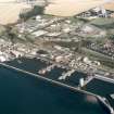
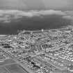
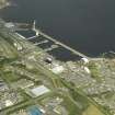
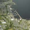
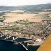
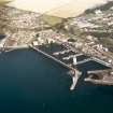
(Location cited as NJ 432 661). Buckie Harbour, built 1878. A large rectangular concrete harbour formed by a shirt straight pier and a long L-plan pier, and divided into five basins by four piers. There are slipways at both ends of the harbour, that at the E end (NJ46NW 13) being used for building as well as repairing. At the entrance is a tapered circular-section concrete light-tower (NJ46NW 15.01).
J R Hume 1977.
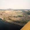
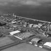
The fully-developed modern installations at the fishing port of Buckie, and the neighbouring subsidiary works, are naturally well outside the scope of the present study - apart, perhaps, from the object-lesson of Buckpool harbour (NJ46NW 8.00), choked up by sand and gravel washed in through the entrance. Some facts, however, about the port's traditional origins may be quoted from the two Statistical Accounts, read in conjunction.
What is called a fishing-station is said to have existed here since the middle of the 17th century, and in 1723 a single crew moved from Buckie to Gollachy (Port Gordon) as they found it 'safer and more commodious' than their former base. This early settlement, presumably on the 'Buckie Shore' of Roy's map (1747-55) seems to have been on the W side of the Burn of Buckie, but no evidence is forthcoming for the date of that on the E, where the ground had a different proprietor. By 1794 the fisheries had come to support fourteen boats and a yawl, the latter for inshore work, while merchants and other traders owned six sloops of from 18 to 60 tons burden. A harbour was thus badly needed and negotiations for building one were going on but had so far borne no fruit; the fact that two proprietors were involved seems to have retarded progress. No positive date is given for the earliest harbour's construction, but in 1847 some improvements had recently been made to works then in existence. In 1842, Buckie had 117 large fishing-boats and 28 small ones.
A Graham 1979, visited 1973.
Cluny Harbour [NAT]
OS 1:10,000 map, 1988.
Air photographs: AAS/97/12/G27/4-5 and AAS/97/12/CT.
NMRS, MS/712/29.
Construction (1874 - 1880)
Built. Early example concrete in pier construction.
Publication Account (2007)
Buckie Harbour
The first significant harbour at Buckie, about 34 mile west of the main harbour and enclosing about 4 acres between two piers,was built in ca.1855 to the design of D. & T. Stevenson.
The present harbour at the Salter’s Bay site was recommended for a fishing harbour by Telford in 1805 and later the Stevensons. It was eventually built from 1874–80 by direct labour and extended between 1888 and 1921. The 1874–80 work represents an early example of the use of
concrete in pier construction. The traditional and new construction can be seen in the cross-sections.
This harbour is also unusual in having a layout with a long pier parallel to the shoreline adjoining five jetties from the shore which divided the harbour into four basins. The entrance is sheltered by an extension to the
main pier with a lighthouse at its end.
The consulting engineer to John Gordon of Cluny, who met the £60 000 cost of the 1874–80 work, was W. Dyce Cay who designed the project. The engineer responsiblefor detailed design was David Cunningham and the
resident engineer was James Barron. A model of the harbour gained a silver medal at the International Fisheries Exhibition at Edinburgh in ca.1882.
The harbour is now used for fishing, general cargo and recreation.
R Paxton and J Shipway, 2007.
Reproduced from 'Civil Engineering heritage: Scotland - Highlands and Islands' with kind permission from Thomas Telford Publishers.

