
Pricing Change
New pricing for orders of material from this site will come into place shortly. Charges for supply of digital images, digitisation on demand, prints and licensing will be altered.
Ballachar


Cairnfield (Period Unknown), Field System (Medieval) - (Post Medieval), Hut Circle (Prehistoric)(Possible), Township (Medieval) - (Post Medieval)
Site Name Ballachar
Classification Cairnfield (Period Unknown), Field System (Medieval) - (Post Medieval), Hut Circle (Prehistoric)(Possible), Township (Medieval) - (Post Medieval)
Alternative Name(s) Dalcrombie
Canmore ID 13084
Site Number NH62NW 12
NGR NH 6170 2840
NGR Description Centred NH 6170 2840
Datum OSGB36 - NGR
Permalink http://canmore.org.uk/site/13084


- Council Highland
- Parish Daviot And Dunlichity
- Former Region Highland
- Former District Inverness
- Former County Inverness-shire
Field Visit (14 December 1971)
NH62NW 12 centred 617 284
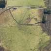
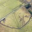
Centred at NH 617 284 is a field system with two probably contemporary circular stone-walled huts (A and B) near its W edge.
Hut 'A' is visible as an ill-defined platform c. 11.5m in diameter with the merest traces of a surrounding stone wall. No entrance is visible. 'B' is truncated in the SSW by a roadside ditch, and measures 9.5m E-W between the centres of a wall spread to c. 2.0m. The entrance is not evident.
Immediately to the NE of the huts are the ill-defined footings of about a dozen rectangular houses of a later period, each laid up and down the slope and averaging about 12.0m by 5.0m.
The field system is marked mainly by stone clearance heaps with occasional lynchets and ruinous walls. Details of cultivation plots are obscured by peat and deep heather.
Huts surveyed at 1/2500.
Visited by OS (A A) 14 December 1971.
Field Visit (18 November 1992)
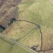
A cluster of buildings, possibly a relatively early township, is situated on a slight spur immediately to the N of the public road to the E of Dalcrombie. Small cairns are spread across the hillside to the N, which has been partially improved, skewing the distribution of the cairns to the E half of the field. Large field banks probably form part of a pattern of large-scale land-division.
The township comprises at least nineteen buildings disposed across a gentle slope to the N of the public road. The buildings appear to post-date the scatter of small cairns extending up the slope to the NE, and two of the buildings overlie a C-shaped bank. The buildings lie approximately across the contour, aligned from N-S to NE-SW. Most are round-ended with an entrance midway along one side. The largest building measures 16.4m in length overall, the others measuring between 7m and 14m in length by 3.8m transversely within stone-faced banks measuring up to 1.2m in thickness and 0.4m in height. Three of the buildings (USN93 233-5) are adjacent to circular or oval shallow depressions up to 10m across, which may be enclosures or middens.
There are at least ninety small cairns extending up the slope to the NE of the buildings in a band 350m long and about 150m across; the ground to the NE and SE having been improved. The cairns measure up to 6m in diameter and 0.5m in height. Within the area of the cairns there are fragmentary banks which may be little more than linear clearance. In addition, the scatter of cairns is bisected by a C-shaped bank extending for about 450m, in an arc to the NE, and roughly symmetrical with, the cluster of buildings. This bank forms part of an extensive system of land division, which extends for at least 500m to the E and NE, and forms part of a wider system of banks running through to adjacent sites (see NH62NW 7.00, 10, and 11). There is also a possibility that the system of enclosure may extend for much greater distances to the E, for example including banks some 1.5km to the E (NH62NW 40).
What may be a hut-circle (USN93 247) is situated on a small terrace at the N fringe of the small cairns, and is crossed by a wire fence. It is sub-circular, measuring about 10.2m in diameter within a heather-covered bank spread to 2.3m in thickness and 0.3m in height.
(USN93 232-7)
Visited by RCAHMS (DCC) 18 November 1992.
Management (2007)
Scheduled as 'Ballachar, settlement, hut circles and field systems... the remains of two prehistoric hut circles, nineteen rectilinear and sub-rectangular structures, forming a township of medieval or later date, a number of clearance cairns and a series of lynchets or dykes, including a head dyke, all sitting on a slight spur towards the upper reaches of a wide valley.'
Information from Historic Scotland, scheduling document dated 20 March 2007.

