|
Manuscripts |
MS 124/3 |
Records of the Royal Commission on the Ancient and Historical Monuments of Scotland (RCAHMS), Edinbu |
Field notebook No. 2, A Graham (RCAHMS). |
8/8/1942 |
Item Level |
|
 |
Digital Files (Non-image) |
WP 002403 |
Records of the Royal Commission on the Ancient and Historical Monuments of Scotland (RCAHMS), Edinbu |
Scanned copy of RCAHMS Emergency Survey: Manuscripts (1943 Volume 2). |
1943 |
Item Level |
|
 |
Digital Files (Non-image) |
WP 002405 |
Records of the Royal Commission on the Ancient and Historical Monuments of Scotland (RCAHMS), Edinbu |
RCAHMS Emergency Survey: Typescripts (Ross and Cromarty). |
1943 |
Item Level |
|
|
Manuscripts |
MS 36/275 |
Records of the Royal Commission on the Ancient and Historical Monuments of Scotland (RCAHMS), Edinbu |
RCAHMS Emergency Survey; manuscripts 1943 (vol.2) |
1943 |
Item Level |
|
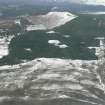 |
On-line Digital Images |
DP 341674 |
Papers of James Sloan Bone, landscape historian, Inverness, Highland, Scotland |
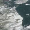
General oblique aerial view of part of the Strath Sgitheach, west of Dingwall, Ross-shire, looking W. |
6/3/2009 |
Item Level |
|
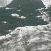 |
On-line Digital Images |
DP 341676 |
Papers of James Sloan Bone, landscape historian, Inverness, Highland, Scotland |
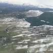
Oblique aerial view of Upper Strath Sgitheach north of Dingwall, Ross-shire, looking W. |
6/3/2009 |
Item Level |
|
 |
On-line Digital Images |
DP 341677 |
Papers of James Sloan Bone, landscape historian, Inverness, Highland, Scotland |
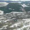
Oblique aerial view of croft land and commercial forestry above Heights of Fodderty near Dingwall, Ross-shire, looking WSW. |
6/3/2009 |
Item Level |
|
 |
On-line Digital Images |
DP 341687 |
Papers of James Sloan Bone, landscape historian, Inverness, Highland, Scotland |
General oblique aerial view of the south facing slopes above and to the north of the River Peffery west of Dingwall Ross-shire, looking W. |
6/3/2009 |
Item Level |
|
 |
On-line Digital Images |
DP 341688 |
Papers of James Sloan Bone, landscape historian, Inverness, Highland, Scotland |
General oblique aerial view of part of the Strath Sgitheach of the River Peffery W of Dingwall, Ross-shire, on the left, and of upper Strath Sgitheach on the right, looking W. |
6/3/2009 |
Item Level |
|
 |
Digital Files (Non-image) |
WP 007515 |
Publications by the Royal Commission on the Ancient and Historical Monuments of Scotland |
(6) The Archaeological Sites and Monuments of Easter Ross, Ross and Cromarty District |
2/1979 |
Item Level |
|
 |
On-line Digital Images |
SC 2363069 |
Records of the Ordnance Survey, Southampton, Hampshire, England |
Heights Of Keppoch, NH56SW 5, Ordnance Survey index card, Recto |
1958 |
Item Level |
|
 |
On-line Digital Images |
SC 2363070 |
Records of the Ordnance Survey, Southampton, Hampshire, England |
Heights Of Keppoch, NH56SW 5, Ordnance Survey index card, Recto |
1958 |
Item Level |
|
 |
On-line Digital Images |
SC 2363071 |
Records of the Ordnance Survey, Southampton, Hampshire, England |
Heights Of Keppoch, NH56SW 5, Ordnance Survey index card, Recto |
1958 |
Item Level |
|
|
All Other |
551 166/1/1 |
Records of the Ordnance Survey, Southampton, Hampshire, England |
Archaeological site card index ('495' cards) |
1947 |
Sub-Group Level |
|


