
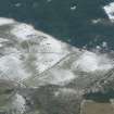
Heights Of Brae


Field System (Prehistoric)(Possible), Hut Circle(S) (Prehistoric)
Site Name Heights Of Brae
Classification Field System (Prehistoric)(Possible), Hut Circle(S) (Prehistoric)
Canmore ID 12941
Site Number NH56SW 3
NGR NH 51467 61277
NGR Description NH 51467 61277, NH 51533 61355 and NH c.5147 6136
Datum OSGB36 - NGR
Permalink http://canmore.org.uk/site/12941


- Council Highland
- Parish Fodderty
- Former Region Highland
- Former District Ross And Cromarty
- Former County Ross And Cromarty
NH56SW 3 514 613.
(NH 51346134) Enclosure (NR).
OS 6"map, (1967)
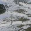
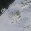
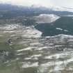
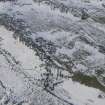
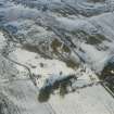
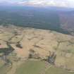
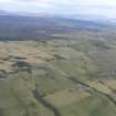
In an areas of rough grazing and recent cultivation is a settlement of four hut circles ('A'-'D').
Hut 'A' published on the OS map as an enclosure measures about 13.0 m in diameter within a wall which is mutilated on all but the N side of the entrance in the SE, where it is spread to about 3.0 m. The inner face is visible intermittently in the S, E, and W arcs, and probable displaced facing stones lie within the hut. A field wall extends from the S side of the entrance as far as a later track to the SE of the hut.
The remaining three huts were discovered by NKB (OS field surveyor 1 July 1965). 'B' is about 10.5 m in diameter within a denuded wall of 2.5m average spread. Its NE arc is the best preserved. The entrance was probably in SE. The hut is partially obscured by whins.
'C' is approximately 11.5 m in diameter within a slight bank, severely obscured by peat "build up". The W arc has been destroyed. The entrance is not obvious but was probably in the SE arc.
'D' set into the slope in the SW is 15.0 m in diameter within a turf covered wall of 3.0 m average spread. The entrance is in the SE. A large pile of modern clearance has been dumped within the huts E arc. In the vicinity of the huts are traces of contemporary field walls, largely obscured by later cultivation.
Surveyed at 1:2500.
Visited by OS (J B) 15 November 1976.
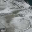
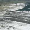
In addition to the four known hut-circles there is an enclosure which may mark the position of a fifth house. It lies on a slight rise above, and c 87m NW of hut-circle 'A', and is crossed from NNW to SSE by a fence-line. It measures 8.5m in diameter over a shallow penannular
ditch measuring about 2m in breadth; there are traces of a very low bank on the outer edge of the ditch and there is a broad entrance gap on the SSE.
Visited by RCAHMS (JRS) 3 March 1989.
Field Visit (30 August 1943)
This site was included within the RCAHMS Emergency Survey (1942-3), an unpublished rescue project. Site descriptions, organised by county, vary from short notes to lengthy and full descriptions and are available to view online with contemporary sketches and photographs. The original typescripts, manuscripts, notebooks and photographs can also be consulted in the RCAHMS Search Room.
Information from RCAHMS (GFG) 10 December 2014.
Field Visit (September 1978)
Heights of Brae NH 514 613 NH56SW 3
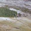
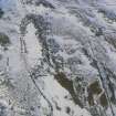
A group of about five hut-circles which measure up to 13.5m in internal diameter. One is set on a platform scooped into the slope.
RCAHMS 1979, visited September 1978

