
Following the launch of trove.scot in February 2025 we are now planning the retiral of some of our webservices. Canmore will be switched off on 24th June 2025. Information about the closure can be found on the HES website: Retiral of HES web services | Historic Environment Scotland
Castle Spynie


Broch (Iron Age)(Possible), Dun (Prehistoric)(Possible), Outworks (Prehistoric)
Site Name Castle Spynie
Classification Broch (Iron Age)(Possible), Dun (Prehistoric)(Possible), Outworks (Prehistoric)
Alternative Name(s) Leanach
Canmore ID 12751
Site Number NH54SW 9
NGR NH 54172 42053
Datum OSGB36 - NGR
Permalink http://canmore.org.uk/site/12751


- Council Highland
- Parish Kiltarlity And Convinth
- Former Region Highland
- Former District Inverness
- Former County Inverness-shire
NH54SW 9 5414 4204
(NH 5414 4204) Castle Spynie (NAT)
Broch (NR)
OS 25" map, (1969)
Castle Spynie is described by Feachem (R W Feachem 1963) as a broch with outworks, and by Anderson (G Anderson 1857) and MacKenzie (G Mackenzie 1857) as a fort.
Anderson states that from the middle of the N side of the fort itself are indications of a second wall, with below it a ditch which curves around the whole of the NE and E sides. This ditch has an outer breastwork composed of a line of large upright stones. About a dozen pieces of vitrifaction were found between these stones and the fort. Below this is another ditch, four or five feet deep, fronted by a mound of earth and stones.
G Anderson 1857; G Mackenzie 1857
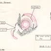
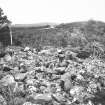
Castle Spynie is a near-circular dun, measuring about 19.5m overall, occupying the summit of a prominent rocky hill. The outer face is visible intermittently amidst tumble around the whole periphery to a maximum height of 1.0m, and the inner face can be seen in the SW arc to a height of 0.8m, indicating a wall thickness of about 4.0m. The entrance in the SW, 1.0m wide, has been cleared of stones, and the SE side rebuilt.
Around the NE and SW sides of the dun at a lower level, are traces of outworks, overgrown with bracken and trees, which appear to have connected with natural out-crop and cliff to form a complete, encircling, outer defence. In the NE is a curving line of boulders, some of which are displaced, fronted by two walls which are reduced to stony banks of indeterminate thickness. Only at the extreme S end of the outer wall where it connects with the cliff can the outer face be seen. Nothing is visible of the ditches described by Anderson and MacKenzie, nor of the second wall from the middle of the N side of the dun.
Some 30.0m SW of the dun is a curving ditch, c. 4.0m wide and c. 1.0m maximum depth, the N part of which incorporates outcrop on its inner side. Immediately to the N of this is a discontinuious line of at least four boulders which partially block the only logical means of access to the dun.
There is no trace of vitrifaction on or around the site, and the present remains of the dun itself indicate beyond doubt that it was not a timber-laced structure.
See 1:1250 enlargement.
Visited by OS (N K B), 9 December 1970.
Broch, Castle Spynie: The remains of what is probably a broch occupy the summit of a rocky knoll 600 m WNW of Leanach. It measures 11 m in diameter within a wall 4.3 m thick; the entrance is on the SW. There are outworks on the N and SW.
RCAHMS 1979 .
Castle Spynie has some of the prerequisites of a broch in that it is roughly circular, 19.0 m in diameter over all and has an undoubted wall thickness of 4.2 m in the SSE. However, the outer face of the wall lacks in the base courses any massive or large stones expected in supporting a relatively high wall; also the wall exterior is grounded on the slope about 1m below interior level, a mode of construction commonly observed in duns. Furthermore, the amount of debris around and at the base of the structure is commensurate with a dun rather that a broch.
On balance, in the absence of evidence of mural chambers and / or galleries, a dun is the appropriate classification.
Visited by OS (J M), 6 February 1981.
Field Visit (16 August 1943)
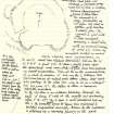
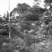
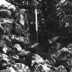
Castle Spynie occupies the summit of a small high peak on the Aird plateau overlooking the sources of the twin burns that flow out through the common gorge near Milifiach and midway between Crockanord farm and Dun Mor. It thus commands a wide view over the Beauly Firth as well as along the ridge over Dun Mor (q.v.) but is not itself visible from the foot of the ridge being hidden by a lower knoll between two burns. The summit is a crag, precipitous on all sides but clad in patches with heather and small firs. The summit is girt with a drystone rampart forming a small dun with an overall diameter of some 62 ft. Where the rampart rested on naked steeply-sloping rock, particularly on the south, much has slipped downhill, but on the W, N and NE a great pile of stones, visible from afar, is preserved and some strips of outer face have been exposed by casual excavation. These all lie on the circumference of a circle of radius 31 ft, but on the S, between two projecting bosses of naked rock, some stones that look like footings of the other face seem to lie in a straight line for some 16 ft – the status of these is however definitely uncertain.
To the SW there is an entrance passage through the wall 12 ft long 6 ft wide at the mouth but contracting after 3 ft to 3 ft 6 inches. The N face is well preserved but on the S the passage wall seems to have been repaired and perhaps augmented recently. Access to the entrance is obtained up a narrow fissure in the rock opening to the NW, the mouth of which may have been narrowed by an outwork.
The inner face is exposed only at the return of the passage. The interior seems mainly occupied by rock bosses covered with thin heather and fir trees and 6 or more feet higher than the expose outer face of the rampart.
Visited by RCAHMS 16 August 1943
(T D Wallace gives the external diameter as 63 ft and the wall thickness as 14 ft so internal diameter of 36 ft. He suggests comparison with brochs but admits the absence of distinctive features. I agree with him).
Field Visit (9 April 1957)
'On visiting the site on 9 April 1957 I was able to see that the north flank of the knoll on which the broch stands was defended by a heavy wall including some gigantic boulders. The whole needs to be planned. Site best approached from E, from Easter Clunes, whose fields come to within 250 yds of the work. Decision required – is it a broch, as I think, or a dun as VGC [Childe] thought'.
Note added by R W Feachem to MS 36/275 p.114
Field Visit (9 December 1970)
NH54SW 9 5414 4204
(NH 5414 4204) Castle Spynie (NAT)
Broch (NR)
OS 25" map, (1969)
Castle Spynie is described by Feachem (R W Feachem 1963) as a broch with outworks, and by Anderson (G Anderson 1857) and MacKenzie (G Mackenzie 1857) as a fort.
Anderson states that from the middle of the N side of the fort itself are indications of a second wall, with below it a ditch which curves around the whole of the NE and E sides. This ditch has an outer breastwork composed of a line of large upright stones. About a dozen pieces of vitrifaction were found between these stones and the fort. Below this is another ditch, four or five feet deep, fronted by a mound of earth and stones.
(G Anderson 1857; G Mackenzie 1857)
Castle Spynie is a near-circular dun, measuring about 19.5m overall, occupying the summit of a prominent rocky hill. The outer face is visible intermittently amidst tumble around the whole periphery to a maximum height of 1.0m, and the inner face can be seen in the SW arc to a height of 0.8m, indicating a wall thickness of about 4.0m. The entrance in the SW, 1.0m wide, has been cleared of stones, and the SE side rebuilt.
Around the NE and SW sides of the dun at a lower level, are traces of outworks, overgrown with bracken and trees, which appear to have connected with natural out-crop and cliff to form a complete, encircling, outer defence. In the NE is a curving line of boulders, some of which are displaced, fronted by two walls which are reduced to stony banks of indeterminate thickness. Only at the extreme S end of the outer wall where it connects with the cliff can the outer face be seen. Nothing is visible of the ditches described by Anderson and MacKenzie, nor of the second wall from the middle of the N side of the dun.
Some 30.0m SW of the dun is a curving ditch, c. 4.0m wide and c. 1.0m maximum depth, the N part of which incorporates outcrop on its inner side. Immediately to the N of this is a discontinuious line of at least four boulders which partially block the only logical means of access to the dun.
There is no trace of vitrifaction on or around the site, and the present remains of the dun itself indicate beyond doubt that it was not a timber-laced structure.
See 1:1250 enlargement.
Visited by OS (N K B), 9 December 1970.
Field Visit (January 1978)
Castle Spynie NH 541 420 NH54SW 9
The remains of what is probably a broch occupy the summit of a rocky knoll 600m WNW of Leanach. It measures 11 m in diameter within a wall 4.3m thick; the entrance is on the SW. There are outworks on the N and SW.
RCAHMS 1979, visited January 1978
(Feachem 1977, 164)
Field Visit (6 February 1981)
Castle Spynie has some of the prerequisites of a broch in that it is roughly circular, 19.0 m in diameter over all and has an undoubted wall thickness of 4.2 m in the SSE. However, the outer face of the wall lacks in the base courses any massive or large stones expected in supporting a relatively high wall; also the wall exterior is grounded on the slope about 1m below interior level, a mode of construction commonly observed in duns. Furthermore, the amount of debris around and at the base of the structure is commensurate with a dun rather that a broch.
On balance, in the absence of evidence of mural chambers and / or galleries, a dun is the appropriate classification.
Visited by OS (J M), 6 February 1981.
Publication Account (2007)
NH54 1 CASTLE SPYNIE
NH/5414 4204
This probable broch (or dun) in Kintarlity and Convinth, Inverness-shire, occupies a rocky knoll with steep sides on the north side and shallower approaches on the south and west; it stands near the south shore of the Beauly Firth. The diagnosis of this site as either a hollow-walled broch or a solid-walled dun has not yet been finally determined, although the absence of large quantities of stone debris may indicate the latter [1].
The entrance has been cleared and is on the south-west, but there are no signs of the door-frame. The outer wallface is visible intermittently, and on the north-west it stands four courses (1.0m) high above the rubble; the inner face can be seen on the south-west to a maximum height of 0.8m. No signs of an intramural gallery can be seen at present. Traces of outer fortifications are visible including, on the north-east, a section of curved wall composed of gigantic boulders fronted by two walls which are now reduced to stony banks [1]. Ditches were described in 1857 [2] but nothing of these can be seen now.
Dimensions (taken by author in 1985): wall thickness at 1 o'clock 3.9m (13.0 ft), diameter on 1-7 o'clock axis 19.95m (66.5 ft), wall thickness at 4 o'clock 3.9m (13 ft) and internal diameter here 10.8m (36 ft). The structure may thus be slightly oval, with estimated overall diameters of 19.95 and 18.60m.
Sources: 1. NMRS site no. NH 54 SW 9: 2. Anderson 1857, 188-9: 3. Mackenzie 1857, 189-91 and fig.: 4. Feachem 1963, 164: 5. RCAHMS 1979b, 17, no. 100.
E W MacKie 2007

