 |
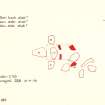
On-line Digital Images |
DP 246447 |
Records of the Ordnance Survey, Southampton, Hampshire, England |
Plan, copied from Ordnance Survey Record Card |
10/4/1973 |
Item Level |
|
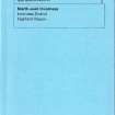 |
Digital Files (Non-image) |
WP 007517 |
Publications by the Royal Commission on the Ancient and Historical Monuments of Scotland |
(8) The Archaeological Sites and Monuments of North-east Inverness, Inverness District |
10/1979 |
Item Level |
|
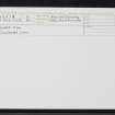 |
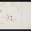
On-line Digital Images |
SC 2362628 |
Records of the Ordnance Survey, Southampton, Hampshire, England |
Lower Bog, NH54SW 12, Ordnance Survey index card, Recto |
c. 1958 |
Item Level |
|
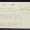 |
On-line Digital Images |
SC 2362629 |
Records of the Ordnance Survey, Southampton, Hampshire, England |
Lower Bog, NH54SW 12, Ordnance Survey index card, page number 1, Recto |
c. 1958 |
Item Level |
|
 |
On-line Digital Images |
SC 2362630 |
Records of the Ordnance Survey, Southampton, Hampshire, England |
Lower Bog, NH54SW 12, Ordnance Survey index card, page number 2, Verso |
c. 1958 |
Item Level |
|
 |
On-line Digital Images |
SC 2362631 |
Records of the Ordnance Survey, Southampton, Hampshire, England |
Lower Bog, NH54SW 12, Ordnance Survey index card, Recto |
c. 1958 |
Item Level |
|
|
All Other |
551 166/1/1 |
Records of the Ordnance Survey, Southampton, Hampshire, England |
Archaeological site card index ('495' cards) |
1947 |
Sub-Group Level |
|


