
Lower Bog


Chambered Cairn (Neolithic)
Site Name Lower Bog
Classification Chambered Cairn (Neolithic)
Alternative Name(s) Auchvaich
Canmore ID 12736
Site Number NH54SW 12
NGR NH 52362 40392
Datum OSGB36 - NGR
Permalink http://canmore.org.uk/site/12736


- Council Highland
- Parish Kiltarlity And Convinth
- Former Region Highland
- Former District Inverness
- Former County Inverness-shire
NH54SW 12 5236 4038.
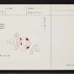
At NH 5236 4038 are several boulders (Mrs T Fraser, Auchvaich, Kiltarlity, Inverness-shire) constituting the ruinous chamber of an otherwise destroyed Orkney-Cromarty cairn. The remains are fragmentary but the chamber seems likely to have been rectangular.
Only four stones are upright, one of these 'D' possibly not in situ, and nine others are fallen. The two westerly uprights are a pair of transverse slabs bisecting the chamber and forming the E side of a rectangular compartment whose other sides have probably been formed by slabs 'A', 'B', and 'C', now fallen or pushed outwards. Another fallen slab inside this compartment may have been a lintel. The other upright slab to the NE appears to be a portal stone.
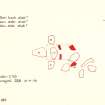
The cairn material has been removed since before Fraser's father's time but occasional stones under the leaf mould and several quarry pits around the chamber suggest its original diameter was about 16.0m. About 120.0m to the SE on the S side of the road are about half a dozen denuded stone clearance heaps of the type usually found with hut circles.
Surveyed at 1:2500 scale.
Enlargement at 1:125 scale.
Visited by OS (I S S) 10 April 1973.
Field Visit (January 1978)
Lowerbog NH 524 402 NH54SW 12
There is a group of at least four small cairns in open woodland 350m WNW of Lowerbog farmhouse and S of the public road. One of them appears to be kerbed.
RCAHMS 1979, visited January 1978
Field Visit (July 1979)
Lowerbog NH 523 403 NH54SW 12
The remains of this Orkney-Cromarty cairn stand 450m WNW of Lowerbog farmhouse. The cairn, which measures about 16m in diameter, has been extensively robbed, but a two compartment chamber, entered from the E, can still be seen.
RCAHMS 1979, visited July 1979

