
Pricing Change
New pricing for orders of material from this site will come into place shortly. Charges for supply of digital images, digitisation on demand, prints and licensing will be altered.
Tarradale House


Barrow(S) (Prehistoric), Barrow Cemetery (Prehistoric), Square Barrow(S) (Iron Age)
Site Name Tarradale House
Classification Barrow(S) (Prehistoric), Barrow Cemetery (Prehistoric), Square Barrow(S) (Iron Age)
Canmore ID 12684
Site Number NH54NW 25
NGR NH 5494 4895
Datum OSGB36 - NGR
Permalink http://canmore.org.uk/site/12684


- Council Highland
- Parish Urray (Ross And Cromarty)
- Former Region Highland
- Former District Ross And Cromarty
- Former County Ross And Cromarty
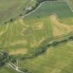
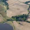
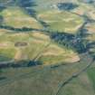
NH 549 489 Cropmarks, cluster of at least five ring-ditches, with possibly two square enclosures, to the N and E of the pentagonal enclosure 400m NW of Tarradale House. Diameter of the three largest circles is c 10-12m. Has the appearance of a barrow cemetery. Noted as 'three ring-ditches' in RCAHMS catalogue of APs, 1978, 18.
J S Bone 1996
Though previously described as ring-ditches, recent aerial photographs (RCAHMSAP 1995) suggest that this is the site of a barrow cemetery containing at least 15 round and square barrows, situated 400m NW of Tarradale House (NH54NE 28), concentrated on the NW and SW side of a plantation bank (NH54NW 122). There are at least three square barrows measuring 5-6m across. The internal diameter of the larger round barrows, visible mainly to the NW side of the plantation bank, are approximately 13-16m. At least five of the barrows have a visible central pit which may represent burials. A possible large round barrow is situated immediately between these barrows (NH54NW 24).
Information from RCAHMS (KJ) 14 June 1999.
Note (1979)
Tarradale House NH 549 489 NH54NW
Air photography has revealed the crop-marks of at least three ring-ditches 400m NW of Tarradale House. See also nos. NH54NW 23 and NH54NW 24.
RCAHMS 1979
Aerial Photographic Interpretation (1996)
NH 549 489 Cropmarks, cluster of at least five ring-ditches, with possibly two square enclosures, to the N and E of the pentagonal enclosure 400m NW of Tarradale House. Diameter of the three largest circles is c 10-12m. Has the appearance of a barrow cemetery. Noted as 'three ring-ditches' in RCAHMS catalogue of APs, 1978, 18.
J S Bone 1996
Aerial Photographic Interpretation (14 June 1999)
Though previously described as ring-ditches, recent aerial photographs (RCAHMSAP 1995) suggest that this is the site of a barrow cemetery containing at least 15 round and square barrows, situated 400m NW of Tarradale House (NH54NE 28), concentrated on the NW and SW side of a plantation bank (NH54NW 122). There are at least three square barrows measuring 5-6m across. The internal diameter of the larger round barrows, visible mainly to the NW side of the plantation bank, are approximately 13-16m. At least five of the barrows have a visible central pit which may represent burials. A possible large round barrow is situated immediately between these barrows (NH54NW 24).
Information from RCAHMS (KJ) 14 June 1999.
Field Visit (2012)
NH 54 48, NH 54 49, NH 55 48 and NH 55 49 The Tarradale Archaeological Project (an approved NOSAS project) aims to investigate, record and interpret the multi-period archaeological landscape of the Tarradale area and to identify the main periods of settlement and resource utilisation. Tarradale was formerly a parish itself, covering about 750ha of land at the W end of the Black Isle and immediately E of Muir of Ord. The area currently being studied consists of raised estuarine beaches underlying flat, high quality, agricultural land. Apart from the medieval Gilchrist Chapel and a small area of irregular mounds, few standing or surface archaeological monuments survive in an area that is intensively ploughed, although aerial photographs show cropmarks that can be interpreted as ring ditches, pits and enclosures, with one concentration of ring and square ditches suggesting the presence of a Late Iron Age/Early Historic barrow cemetery. This contrasts with the more upland pastoral and wooded landscape where there are standing monuments including chambered cairns, one of which is the Tarradale chambered cairn.
Fieldwalking in the fields to the E and W of Tarradale House early in 2012 produced 237 lithic finds, mainly flint and many of them of microlithic size. The density of finds in relation to the area covered is low and most of the lithic finds are very small and difficult to see in a soil that is derived from coarse sand and pebbles. It appears that quartz and quartzite were also being used for artefact manufacture, probably due to the shortage of flint which does not occur naturally in the area. The project steering group decided that intensive fieldwalking should be undertaken by parallel traverses spaced 1m apart, with individual lithic, early pottery and metalwork find sites plotted using GPS. This essentially meant that all the surface area was being visually scanned for artefact survival.
The majority of the lithic finds can be classified as debitage, but there are a number of reworked flakes, end scrapers and side scrapers. An analysis of their distribution has led to the preliminary identification of a number of potential ‘hot spots’. Lithic finds also included a few larger flakes as well as a tanged and barbed arrowhead, and a number of stone spindle whorls. The lithic finds have not yet undergone detailed analysis. Supervised metal detecting of the ploughsoil revealed the broken off cutting edge of a Late Bronze Age socketed axe and a lead spindle whorl.
Fieldwalking and controlled metal detecting has also provided a picture of a general background noise of medieval pottery and a few medieval coins (for example a silver short cross penny of King Henry III of England, issued 1216–47). However, fieldwalking finds from part of one field (centred on NH 554 487) showed a well defined concentration of degraded pottery sherds, animal bone food waste and iron nails which may indicate the lost location of the former medieval Tarradale Castle that was destroyed by Robert Bruce in 1308. Supervised metal detecting of the ploughsoil in the supposed castle area produced a Henry III long cross penny and a medieval heraldic horse pendant.
Ploughing by the tenant farmer in November 2011 in the field immediately W of Tarradale House (centred on NH 548 487) brought to the surface a dense spread of marine shells, including whole oyster, cockle, mussel, whelk and periwinkle shells, as well as a mass of crushed shells. Two smaller surface spreads of shells were noted close by in an adjacent field. Given that harrowing would destroy the surface evidence, test pitting was carried out in November 2011 to attempt to assess the nature and extent and possible age of these deposits. The test pits provided incontrovertible evidence that there was good preservation of an extensive shell layer below the ploughsoil, though suffering continual degradation due to ploughing. A series of small augur boreholes was sunk to try and delimit the shell layer which was found potentially to cover 500m² and in places is up to 400mm thick and contains many millions of shells. Analysis of a sample of these shells (all of which can be found in the Beauly Firth today) shows a considerable size variation, particularly for periwinkles, with the presence of some tiny periwinkles suggesting that these molluscs were collected by bulk methods. Some of the test pits also produced pieces of antler and bone as well as spreads of charcoal within the shell layer, suggesting that it is a humanly created shell midden rather than a natural deposit of shells. The project is actively seeking funding for radiocarbon dating of these organic deposits to provide an initial chronological parameter for the site.
Archive: Highland HER, local library and RCAHMS (intended)
Funder: NOSAS – in kind
Eric Grant, Tarradale Archaeological Project, 2012
(Source: DES)
Project (2013)
In 2013 the University of Aberdeen undertook a geophysical survey of selected areas of the site using magnetometry and resistivity.
Steven Birch 2020
Earth Resistance Survey (2013)
Resistivity survey.
Steven Birch 2020
Magnetometry (2013)
Magnetometry survey.
Steven Birch 2020
Archaeological Evaluation (August 2019 - September 2019)
NH 5494 4895 (centred) Tarradale Through Time (TTT) is investigating the multi-period archaeological landscape around Tarradale, Ross-shire. Under the direction of the North of Scotland Archaeological Society (NOSAS), TTT aims to interpret the chronological development of settlement through a series of community archaeology projects on five key sites.
The project work proposed for 2019 and the last of the planned excavation-based sub-projects, investigated the Tarradale barrow cemetery. Comprising a site of archaeological significance within the Tarradale landscape, its identification has primarily been through the use and interpretation of aerial photographs and imagery; although in 2013 the University of Aberdeen undertook a geophysical survey of selected areas of the site using magnetometry and resistivity.
A programme of evaluation including geophysical and metal detecting surveys, and open area excavation, with supervision by West Coast Archaeological Services (WCAS) and the University of Aberdeen (UOA), and undertaken by community volunteers, was carried out in August – September 2019. The overall aims and objectives were to locate a selection of the archaeological features seen on the aerial imagery, to characterise the features and what they represent, to ascertain the nature and extent of the surviving archaeology, and to obtain evidence to securely date the features. Much of the site is located in open fields which are cultivated on an annual basis, although an area of uncultivated ground is located almost centrally within the barrow cemetery.
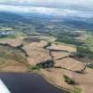
The Tarradale landscape consists of raised estuarine beaches comprising deposits of gravel, sands and silts situated at the W end of the Beauly Firth on the north side of the River Beauly, with the underlying geology dominated by the Raddery Sandstone Formation. The barrow cemetery is located on a terrace overlooking the Beauly Firth, around 300m NW of Tarradale House at an altitude of approximately 15-20m OD; the gently undulating ground rising to the north towards the Mulbuie Ridge – a landscape feature containing many notable prehistoric monuments.
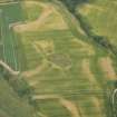
Cropmarks visible on aerial photographs indicate that the barrow cemetery at Tarradale is one of the largest in Scotland. The majority of barrows conform to the sizes and types recorded elsewhere in Scotland, with at least 19 circular barrows (the largest 10–12m in diameter) and four square barrows each measuring around 5–6m across. However, as with some other barrow cemeteries in Scotland, Tarradale has larger circular barrows of up to 20m diameter (at least 6), along with an even larger facetted oval-shaped enclosure measuring at least 36m across at its widest point. Another intriguing feature is a square barrow around 18m across, which lies concentrically within a square enclosure at least 40m across. These variations in size, shape and architectural construction could be suggestive of their importance, their longevity, or both. The aerial images from the Tarradale cemetery show potential cut features within some of the square and round barrows, which may relate to burials. Unenclosed cut features distributed across the cemetery may also represent unenclosed burials and a possible prehistoric pit alignment. The alignment of a former sunken trackway can also be seen cutting through this landscape adjacent to the barrow cemetery, which can be traced as a cropmark for 1.5km from Balnagown, through the centre of the cemetery to the former coastline, where an harbourage may have existed providing a crossing point across the Beauly Firth.
Interpretation of the aerial photographs taken over a number of years at the Tarradale site suggest that some of the barrows have been lost, or at least partially lost – their negative features eroded by aggressive agricultural ploughing, especially during more recent years. However, the aerial evidence is likely to provide an underestimate of the total number of features at the site, while it is also possible that unenclosed graves may be present; for example, as seen at Redcastle, in Angus.
2019 Excavations
Three large open area trenches were opened at Tarradale using mechanical excavators for the 2019 excavations. A ‘strip and map’ methodology was utilised, followed by selective excavation and sampling of archaeological features and deposits.
Trench 1 – investigated a group of three round barrows to the SSW of the unimproved area of ground using an open area measuring approximately 34m NE-SW x 18m NW-SE. Aerial images appear to show cut features within two of the barrows, which may be central grave-cuts. An extension to this trench extended to the NE to investigate the sunken trackway and the unimproved ground, where it is possible that archaeological features are concealed, allowing direct comparisons to be made with regards to their survival with the adjacent features outwith the uncultivated area. The trench extension measured approximately 30m NE-SW x 2m wide.
Stripping of the relatively shallow topsoil from the main open area excavation revealed three complete round barrows (F1.01, F1.03 and F1.04) and segments of three smaller round barrows (F1.02, F1.06 and F1.07), the former located within the uncultivated area of ground, in the NE trench extension. Some of the round barrows lay in close proximity to each other, with their ditches almost touching, and displaying their potential contemporaneity. Other negative features included several small pit features, one containing a charcoal-rich fill and fragments of fire-cracked stone, the sunken trackway F1.05, a low stone revetment wall (F1.09) bounding the uncultivated area of ground, a section of a possible earlier trackway (F1.10) within the uncultivated area, and what appears to be a part of an unenclosed grave (F1.08) aligned SW-NE. A small number of plough furrows were identified within the NW corner of Trench 1, where the natural sediments were less stoney and easier to excavate.
The underlying natural deposits within Trench 1, which is located towards the highest ground on which the cemetery has been constructed, comprises hard, stoney deposits; and it is the hard ground which has possibly protected the barrows and other features from invasive agricultural activities including ploughing. Unfortunately, due to the difficulties encountered in cleaning back this area using hand tools, time did not permit the excavation of any of the enclosed grave cuts; with what appeared to be central graves within round barrows F1.03 and F1.04 (both of which were aligned roughly SW-NE). These proved very difficult to define from the surrounding natural deposits. However, the exposed section of unenclosed grave F1.08 was excavated, although no burial was present – most likely due to the acidic soils.
A number of sondages were cut through the round barrow ditches to define their morphology and investigate the deposits they contain. In particular, samples were taken which will hopefully provide material for radiocarbon dating. The ditches varied in their profiles and surviving depths, which in some instances exceeded 0.4m. Excavation of the sondages also revealed entrances, or causeways, within round barrows F1.01, F1.03, F1.04 and F1.06 (all facing E to ENE).
Trench 2 – was located to assess the most enigmatic features of the cemetery – a large square barrow with causeways at each corner, enclosed by a larger ditched square enclosure; and a large facetted oval enclosure. Large square enclosures show up at a small number of Pictish cemetery sites – for example at the likely royal sites of Rhynie and Forteviot, and at Greshop and Kinchyle. The larger square enclosures do not seem to be barrows, but may be associated with the cemeteries – a form of shrine or enclosure for funeral ceremonies. However, it was thought possible that the outer square enclosure at Tarradale may have related to the enhancement and monumentalising of the enclosed causewayed barrow. The excavations in Trench 2 would evaluate the form, character and chronology of these features in relation to the wider cemetery, and investigate the potential for internal cut features within their confines.
The open area trench (Trench 2b) evaluating the central square barrow within the larger enclosure measured approximately 22m square; while extensions to the SE, NW, NE and SW provided sections through the enclosing outer ditches of the larger square feature. The extension to the SE also investigated the relationship with the adjacent large oval facetted enclosure. An open area trench (Trench 2a) extending off this extension measured 18m NW-SE x 12m NE-SW, to investigate the SW side of the facetted enclosure including its main ditch and any internal features. Similar facetted enclosures have been identified at barrow cemetery sites at Kettlebridge and Melville Home Farm in Fife, adjacent to a large square barrow.
The long NW-SE orientated linear trench also extended into the edge of the uncultivated area of ground and due to develops during topsoil stripping a small open area extension measuring 5m NW-SE x 4.8m was opened to the southwest.
Trench 2a – Removal of the topsoil from this long NW-SE aligned trench and its open area extension revealed a varied subsoil horizon ranging from fine pale yellow sands, through to gritty orange silts containing some small stone clasts. These deposits enabled the cut features containing their associated darker-coloured fills to be identified easily; including the smaller pit features located within, and just outside the ditch of the large oval facetted enclosure F2.01.
The upper fills of the oval ditch of F2.01 varied across Trench 2a, with some areas displaying charcoal-rich deposits and some localised areas of stone infill. A halo of paler-coloured sediments along the inside edge of the ditch, on the NE side, also suggested multiple fills; possibly relating to primary and secondary infilling of the ditch. In order to evaluate the ditch profile and its fills further, four sondages were excavated across its width. These displayed a steeply cut V-shaped profile, with a flat to U-shaped base. The ditch measured between 1.7m-1.9m wide at its top and up to 0.9m deep. The fills within the ditch cut varied significantly between sondages, indicating complex infilling processes; from differing sides of the ditch and the materials introduced. The size of the ditch and its profile would indicate a potential prehistoric date for this facetted oval enclosure, although samples will be submitted for radiocarbon dating to confirm this.
The interior of oval enclosure F2.01 contained bright orange gritty sediments containing small stone clasts and some charcoal smears (C2.22), which reached a maximum depth of 0.18m within the NW arc of the feature. This reduced in thickness to the SE and SW, where it merged into the finer orange sand. It appears likely that this deposit was generated during the use of enclosure F2.01, although from what activity it derives remains unclear without further analysis of the deposit. A number of negative features were identified within the SE end of Trench 2a, just within the area defined by the ditch of F2.01; although one feature was located just outside the ditch on the SW side. Section excavation of the features revealed steep-sided cuts into the natural sand, while their fills resembled deposit (C2.22). Unfortunately, these fills appeared to be devoid of any organic material suitable for radiocarbon dating.
The SE extension of Trench 2a cut into the edge of the uncultivated area of ground and just below the turf matt and upper plough soil a number of features and deposits were encountered. A linear drystone revetting wall [F2.04] appeared to define the edge of the uncultivated ground, and its upper courses to the SW had been truncated by ploughing. The wall survived up to three courses high (0.5m) and had been cut into earlier deposits, while one fragment of dressed sandstone had adhering patches of lime mortar. A shallow ditch located on its outside face contained burnt deposits including orange ash and small branchwood fragments. To the SE, a spread of round stones (most likely field clearance) had been deposited over natural-looking sediments containing numerous stone clasts.
The wall and its associated cut at the SE end of the Trench 2a extension had been cut into the fills of the oval facetted ditch F2.01, almost to the base of the ditch cut which appeared to be shallower here. This provided a complex suite of features displaying good stratigraphic relationships.
The function of the oval facetted enclosure F2.01 remains unclear, but may comprise one of the earlier monuments investigated at the site. Hopefully, radiocarbon dating will confirm this.
Trench 2b – Removal of the topsoil in Trench 2b revealed a continuation of the gritty orange subsoil, but moving to the NW along the trench and downslope into a shallow basin, this transitioned to a pale cream, fine sand. The latter material was prone to severe wind distribution and on windier days would infill any excavated features relatively quickly. Located just over 2m to the NW of the ditch cut of F2.01 in Trench 2a, along the NW-SE orientated Trench 2, the large outer square enclosure ditch was revealed (F2.02). Additional sections of this ditch were also uncovered in the NE, NW and SW extensions to Trench 2b. This is a large feature measuring approximately 45m across. Excavation of sondages across the ditches revealed varied profiles and fills, while truncation of the ditch section in the SW trench extension was severe. Plough truncation within the SW of Trench 2b was the most severe encountered anywhere across the three excavated trenches at Tarradale, which is possibly due to a combination of fine, sandy subsoils and natural sediments, along with the sloping nature of the ground. The SW edge of Trench 2b is located at the base of a slope and it is possible that ploughing down the slope would plunge into these soft deposits, before pulling out to a shallower depth as the ground flattened off.
The alignment of outer square enclosure F2.02 appears to be slightly different to the inner square causewayed enclosure F2.03, while the fills also differ in their make-up. The outer square enclosure ditch segments excavated vary significantly in the profiles and fills – some of which can be explained by the plough truncation. In the SW extension of Trench 2b, the ditch had been severely truncated with the upper cut and its fills completely removed – the resulting interface displayed by a clear line between the remaining ditch and fills and the plough soil above. The ditch here measured 2.4m wide at its top and 0.38m deep, containing alternating lenses of light and dark sandy silts. The ditch section within the Trench 2b NW extension measured 5.1m wide at its top and up to 0.84m deep. Within the NE extension, the ditch cut measured 5.3m wide and up to 0.7m deep, the profile having a long, shallow lead-in from the SW side. The fills of the two ditch sections above also comprised lenses of sediment with high sand content and virtually no stone. Finally, the ditch section in the SE extension of Trench 2b comprised a large and significant feature measuring 8.6m wide at its top and up to 1.2m deep. This long section showed two well-defined cuts within the ditch the earliest containing similar deposits to the other sections. However, the re-cutting of this ditch created a much wider feature and contained quite different fills including large dumps of stone. Artefacts recovered from within and at the base of the stone deposit proved to be post-medieval in date, suggesting that this later cut at least was most likely associated with agricultural improvements in this area of the site.
The inner square enclosure (F2.03) measured around 18m across and comprised four ditch segments of equal length with causeways in each corner. The upper fills displayed mixed infilling deposits – some of which were charcoal-rich, or contained dumps of stone (similar to the stone deposited within the outer square ditch, as above). The ditch segments displayed slight widenings at their terminals, which initially suggested that they may have contained large posts or stones. The SW ditch segment had been severely truncated by ploughing.
Selected section excavation of the ditch segments revealed a U-shaped profile and a fairly uniform depth across their lengths. However, two of the terminals excavated revealed additional cut features, one of which may have housed a rectangular cross-sectioned wooden post, or a stone slab. The fills within the ditches appear to have accumulated in a fairly uniform manner, which may suggest natural infilling of the open features through time. However, the upper, more charcoal-rich deposits including stone may represent deliberate backfilling and decommissioning of the ditches. No features were found within the confines of the enclosure to indicate a central burial, or function for this monument.
Trench 3 – was located to provide a snapshot of the cemetery organization, density of barrows and graves, along with the quality of their survival, and to clarify the cropmarks in a major cluster of barrows within the cemetery to the N of the unimproved area. Measuring approximately 38m E-W x 25m N-S. The interpretation of the aerial images for this area show two of the larger circular enclosures, a fragment of a smaller circular barrow, one of the smaller square barrows, and part of a larger square/trapezoidal barrow. The trench also captured two of the features from a possible pit alignment, which appear to be cut by the barrow/enclosure.
The ploughsoil overlying the natural ground surface in Trench 3 varied between 0.7m-0.8m, a significant difference to Trench 2, which lay at a similar topographic horizon within the site. Its removal revealed a complex suite of features, many of which mirrored exactly the mosaic of aerial images taken over the years at Tarradale. This included the whole of one of the larger circular enclosures (F3.01), a part of a second larger circular enclosure (F3.02), a large part of a smaller circular barrow (F3.05) including a central grave cut (aligned NE-SW), a complete smaller square barrow (F3.04) including central grave cut (aligned NE-SW), a part of a similar sized square barrow (F3.06) and major part of a larger square/trapezoidal barrow or enclosure (F3.03). The larger circular enclosure F3.01 had a causeway facing to the ENE, while the smaller circular barrow F3.05 also had a causeway facing to the NE. The smaller square barrows also had causeways at their corners, almost on an N-S, E-W axis. The larger square/trapezoidal enclosure comprised a continuous ditch and had no visible entrance, which agreed with the interpretation of the aerial imagery. The close proximity of some of the monuments to each other would indicate that the individual features were visible when constructed; and may even be relatively contemporary in date.
The quality of survival of the features, along with other recognised criteria, resulted in very selective excavation in Trench 3, targeting features that have not been investigated in the past. This included Feature F3.01 which contained a number of features within its enclosed space including smaller round pits/post-holes, a larger circular pit containing some large stones (a possible stone hole), a rectangular pit and two of the large pits, which formed a part of a larger possible prehistoric alignment. Excavation of one of these features, which is dissected by the ditch of the circular enclosure, contained complex burnt residues including wood ash in its base, which may suggest the burning took place within the pit. No grave cuts were identified within the enclosure. Sondages taken through the ditch section and at the terminals showed a rounded to U-shaped profile measuring around 0.9m-1.1m wide at the top and between 0.4m-0.5m deep. The ditch fills displayed primary and secondary fills with only small stone clasts present, and with some charcoal-rich deposits – especially within the upper fill of the ditch. Charcoal-rich fills were also identified within the fills of the ditch segments forming square barrow F3.04. These deposits were sampled as a part of a section excavation within the terminal of the NW ditch segment, where the barrow ditch had cut through an area of earlier burnt sediments within an amorphous shaped feature.
The other major monument targeted for sample excavation in Trench 3 was the larger square/trapezoidal barrow or enclosure (F3.03). Sondages taken through its ditch showed a shallower, U-shaped profile with some sections having a flat base – measuring around 1.0-1.3m wide at its top and up to 0.25-0.35m deep. This ditch also contained primary and secondary fills, but little stone and some charcoal-rich areas.
This feature also contained a number of features which were targeted for excavation including two post-holes, a pit and a larger elongated cut containing a stained gravel fill, aligned roughly E-W. This proved to be a deep feature, cut through the underlying gravels, measuring approximately 2.2m long x 0.8m wide. The cut had vertical sides and at a depth of 0.75m below the contemporary ground surface, the remains of a log coffin was identified. This was represented by stained sediments and within its outline the dark stain of a human body was revealed. These were preserved in fine, light-coloured sediments with a creamy texture and with delicate excavation the outline of individual bones could be recognised. The cranium was upstanding, but also appeared to comprise stained sediments with no bone survival. The ankles appeared to be bound together, and the knees were slightly bent outwards to the north – possibly aligning with the slightly bent shape of the log coffin. Although the cranium stood proud of the remainder of the body, the latter had been compressed into a thin layer some 20mm deep, by the overlying gravels. The different alignment of the grave and its location within one corner of the larger square/trapezoidal enclosure, may suggest that this was a later burial within the cemetery.
Other features were identified outside and between the enclosures and barrows within Trench 3 including possible pits and post-holes, and localised spreads of burnt material. However, one larger feature (F3.07 - initially thought to be a ditch segment from an earlier barrow) located within a small space between square barrows F3.04 and F3.06, and the larger trapezoidal enclosure F3.03, was selected for further evaluation. The initial sondage through the feature revealed a semi-circular dark-coloured stain within the section, which contained a complex fill including deposits stained a dull red and containing some charcoal flecks (and little stone). Based on the initial assumption that the dark outline may be another log coffin, aligned roughly E-W, the excavation of the feature continued with its careful dismantling and sampling. No body or body stain was revealed, but the outline of the dark stain and the cut containing it, suggested that this comprised half of a charred log – tapering off to the east.
The excavations now completed, the project is moving forward to post-excavation analysis. This will include sediment analysis and sampling for radiocarbon dating. Artefacts recovered from the site were generally limited to post medieval ceramics, glass and some iron nails within the ploughsoil contexts; and an upper rotary quern stone recovered from the uncultivated area of ground – deposited with stone clearance material.
Archive: Highland Council HER and NRHE (intended)
Funder: Heritage Lottery Fund
Steven Birch - West Coast Archaeological Services
(Source: DES Vol 20)
Unspecified Geophysical Survey Technique (August 2019 - September 2019)
NH 5494 4895 (centred) Geophysical survey.
Archive: Highland Council HER and NRHE (intended)
Funder: Heritage Lottery Fund
Steven Birch - West Coast Archaeological Services
(Source: DES Vol 20)

