Accessibility

Font Size

100% 150% 200%

Background Colour

Default Contrast
Close Reset

Windhill

Ring Ditch (Prehistoric)

Site Name Windhill

Classification Ring Ditch (Prehistoric)

Canmore ID 12680

Site Number NH54NW 21

NGR NH 5350 4850

Datum OSGB36 - NGR

Permalink http://canmore.org.uk/site/12680

Ordnance Survey licence number AC0000807262. All rights reserved.
Canmore Disclaimer. © Bluesky International Limited 2025. Public Sector Viewing Terms

Toggle Aerial | View on large map

Digital Images

Windhill, oblique aerial view, taken from the NW, centred on the cropmarks of a ring-ditch and a possible pit-circle.
Windhill, oblique aerial view, taken from the NW, centred on the cropmarks of a ring-ditch and a possible pit-circle.Windhill, NH54NW 21, Ordnance Survey index card, RectoNear aerial view of the ring ditch at Windhill, Muir of Ord, Black Isle.Windhill, oblique aerial view, taken from the S, centred on the cropmarks of a ring-ditch or pit-circle.Near aerial view of Baxters, Tomich and Windhill Industrial Estates, Muir of Ord, Black Isle, looking SE.Near aerial view of enclosure cropmarks in field near Windhill, Muir of Ord, Black Isle, looking SE.Windhill, oblique aerial view, taken from the SE, centred on the cropmarks of a ring-ditch or pit-circle.Oblique aerial view.Windhill, oblique aerial view, taken from the NE, centred on the cropmarks of a ring-ditch and a possible pit-circle. A standing stone is visible in the top right-hand corner of the photograph.Aerial view of Tomich and Wyndhill Industrial Estates, S of Muir of Ord, Black Isle, looking SW.An oblique aerial view of Muir of Ordnear Muir of Ord, Black Isle, looking S.Oblique aerial view of part of the southern section of the industrial estate at Muir of Ord, Black Isle, looking E.Windhill, NH54NW 21, Ordnance Survey index card, page number 1, RectoWindhill, oblique aerial view, taken from the NNE, centred on the cropmarks of a ring-ditch and a possible pit-circle.Aerial view of Muir of Ord, oblique view of industrial estate and part of Black Isle showground, looking NW.Windhill, oblique aerial view, taken from the NE, centred on the cropmarks of a ring-ditch or pit-circle.Oblique aerial view.

Administrative Areas

  • Council Highland
  • Parish Urray (Ross And Cromarty)
  • Former Region Highland
  • Former District Ross And Cromarty
  • Former County Ross And Cromarty

Archaeology Notes

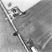
No surface traces visible.

Visited by OS 20 January 1978

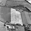
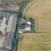
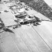
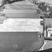
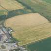
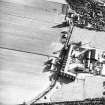
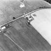
Further aerial photographs have been taken of this site, which appear to show it as a possible double pit circle. (See Archive for details.)

Information from J Harden 1989.

Activities

Field Visit (January 1978)

Windhill NH 535 485 NH54NW

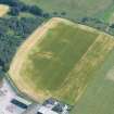
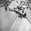
Air photography has revealed the crop-mark of a ring-ditch 600m NE of Tomich House; it measures about 5m in diameter within a ditch about 1.5m broad. Visible on RCAHMS AP 1976.

RCAHMS 1979, visited January 1978

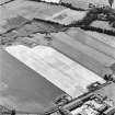
Aerial Photographic Interpretation (4 March 2014)

Following a review of the aerial photographs, the pit circle recorded previously was not identified and has been removed as a classification.

Information from RCAHMS (KMM) 4 March 2014

References

MyCanmore Image Contributions


Contribute an Image

MyCanmore Text Contributions