
Pricing Change
New pricing for orders of material from this site will come into place shortly. Charges for supply of digital images, digitisation on demand, prints and licensing will be altered.
Windhill


Enclosure (Prehistoric)(Possible)
Site Name Windhill
Classification Enclosure (Prehistoric)(Possible)
Canmore ID 12679
Site Number NH54NW 20
NGR NH 5306 4830
Datum OSGB36 - NGR
Permalink http://canmore.org.uk/site/12679


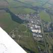

- Council Highland
- Parish Urray (Ross And Cromarty)
- Former Region Highland
- Former District Ross And Cromarty
- Former County Ross And Cromarty
Field Visit (January 1978)
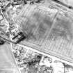
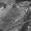
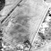
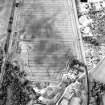
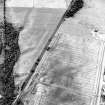
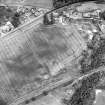
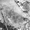
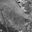
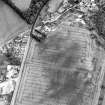
Windhill 1 NH 530 483 NH54NW
Air photography has revealed the crop-mark of a circular enclosure about 25m in diameter, situated immediately SW of the standing stone NH54NW 10. Visible on CUCAP 1955
RCAHMS 1979, visited January 1978

