Accessibility

Font Size

100% 150% 200%

Background Colour

Default Contrast
Close Reset

Windhill

Enclosure (Prehistoric)(Possible)

Site Name Windhill

Classification Enclosure (Prehistoric)(Possible)

Canmore ID 12679

Site Number NH54NW 20

NGR NH 5306 4830

Datum OSGB36 - NGR

Permalink http://canmore.org.uk/site/12679

Ordnance Survey licence number AC0000807262. All rights reserved.
Canmore Disclaimer. © Bluesky International Limited 2025. Public Sector Viewing Terms

Toggle Aerial | View on large map

Digital Images

Oblique aerial view centred on the cropmarks of the enclosure, pit-alignment, linear cropmarks, pits and rig with standing stone adjacent, taken from the NE.
Oblique aerial view centred on the cropmarks of the enclosure, pit-alignment, linear cropmarks, pits and rig with standing stone adjacent, taken from the NE.Oblique aerial view centred on the cropmarks of the enclosure, pit-alignment, linear cropmarks, pits and rig with standing stone adjacent, taken from the WNW.Oblique aerial view centred on the cropmarks of the enclosure, pit-alignment, linear cropmarks, pits and rig with standing stone adjacent, taken from the SE.Oblique aerial view centred on the cropmarks of the enclosure, pit-alignment, linear cropmarks, pits and rig with standing stone adjacent, taken from the SSE.Oblique aerial view centred on the cropmarks of the enclosure, pit-alignment, linear cropmarks, pits and rig with standing stone adjacent, taken from the SE.Windhill, NH54NW 20, Ordnance Survey index card, page number 1, RectoOblique aerial view centred on the cropmarks of the enclosure, pit-alignment, linear cropmarks, pits and rig with standing stone adjacent, taken from the WNW.Oblique aerial view centred on the cropmarks of the enclosure, pit-alignment, linear cropmarks, pits and rig with standing stone adjacent, taken from the SSW.Oblique aerial view centred on the cropmarks of the enclosure, pit-alignment, linear cropmarks, pits and rig with standing stone adjacent, taken from the SSW.An oblique aerial view of Muir of Ordnear Muir of Ord, Black Isle, looking S.Oblique aerial view centred on the cropmarks of the enclosure, pit-alignment, linear cropmarks, pits and rig with standing stone adjacent, taken from the NNW.An oblique aerial view of Muir of Ord, Black Isle, looking NE.

Administrative Areas

  • Council Highland
  • Parish Urray (Ross And Cromarty)
  • Former Region Highland
  • Former District Ross And Cromarty
  • Former County Ross And Cromarty

Activities

Field Visit (January 1978)

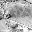
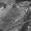
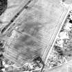
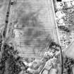
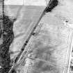
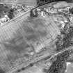
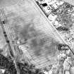
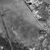
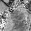
Windhill 1 NH 530 483 NH54NW

Air photography has revealed the crop-mark of a circular enclosure about 25m in diameter, situated immediately SW of the standing stone NH54NW 10. Visible on CUCAP 1955

RCAHMS 1979, visited January 1978

References

MyCanmore Image Contributions


Contribute an Image

MyCanmore Text Contributions