|
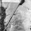
Photographs and Off-line Digital Images |
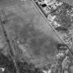
A 54952 |
Records of the Ordnance Survey, Southampton, Hampshire, England |
General view. |
1975 |
Item Level |
|
|
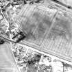
Photographs and Off-line Digital Images |
B 86555 PO |
Cambridge University Collection for Aerial Photography |
|
16/7/1955 |
Item Level |
|
|
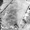
Photographs and Off-line Digital Images |
B 86556 PO |
Cambridge University Collection for Aerial Photography |
|
16/7/1955 |
Item Level |
|
 |
On-line Digital Images |
SC 919479 |
Records of the Ordnance Survey, Southampton, Hampshire, England |
General view. |
1975 |
Item Level |
|
|
Photographs and Off-line Digital Images |
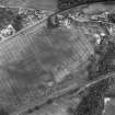
D 74268 |
RCAHMS Aerial Photography |
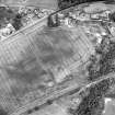
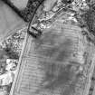
Oblique aerial view centred on the cropmarks of the enclosure, pit-alignment, linear cropmarks, pits and rig with standing stone adjacent, taken from the WNW. |
17/7/2000 |
Item Level |
|
|
Photographs and Off-line Digital Images |
D 74269 |
RCAHMS Aerial Photography |
Oblique aerial view centred on the cropmarks of the enclosure, pit-alignment, linear cropmarks, pits and rig with standing stone adjacent, taken from the NNW. |
17/7/2000 |
Item Level |
|
|
Photographs and Off-line Digital Images |
D 74270 |
RCAHMS Aerial Photography |
Oblique aerial view centred on the cropmarks of the enclosure, pit-alignment, linear cropmarks, pits and rig with standing stone adjacent, taken from the NE. |
17/7/2000 |
Item Level |
|
|
Photographs and Off-line Digital Images |
D 74273 |
RCAHMS Aerial Photography |
Oblique aerial view centred on the cropmarks of the enclosure, pit-alignment, linear cropmarks, pits and rig with standing stone adjacent, taken from the SSE. |
17/7/2000 |
Item Level |
|
|
Photographs and Off-line Digital Images |
D 74274 |
RCAHMS Aerial Photography |
Oblique aerial view centred on the cropmarks of the enclosure, pit-alignment, linear cropmarks, pits and rig with standing stone adjacent, taken from the SSW. |
17/7/2000 |
Item Level |
|
|
Photographs and Off-line Digital Images |
D 74271 |
RCAHMS Aerial Photography |
Oblique aerial view centred on the cropmarks of the enclosure, pit-alignment, linear cropmarks, pits and rig with standing stone adjacent, taken from the SE. |
17/7/2000 |
Item Level |
|
|
Photographs and Off-line Digital Images |
D 74272 |
RCAHMS Aerial Photography |
Oblique aerial view centred on the cropmarks of the enclosure, pit-alignment, linear cropmarks, pits and rig with standing stone adjacent, taken from the SE. |
17/7/2000 |
Item Level |
|
|
Photographs and Off-line Digital Images |
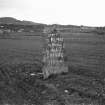
B 11604 |
|
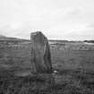
General view of standing stone from SE.
Original print bears annotation: 'No.4. Standing Stone on Road from Kilmorack to Tarradale. Taken about Noon April 1895. A.F.Yule". |
4/1895 |
Item Level |
|
 |
On-line Digital Images |
SC 1354488 |
RCAHMS Aerial Photography |
Oblique aerial view centred on the cropmarks of the enclosure, pit-alignment, linear cropmarks, pits and rig with standing stone adjacent, taken from the WNW. |
17/7/2000 |
Item Level |
|
 |
On-line Digital Images |
SC 1354495 |
RCAHMS Aerial Photography |
Oblique aerial view centred on the cropmarks of the enclosure, pit-alignment, linear cropmarks, pits and rig with standing stone adjacent, taken from the SSW. |
17/7/2000 |
Item Level |
|
 |
Digital Files (Non-image) |
WP 002403 |
Records of the Royal Commission on the Ancient and Historical Monuments of Scotland (RCAHMS), Edinbu |
Scanned copy of RCAHMS Emergency Survey: Manuscripts (1943 Volume 2). |
1943 |
Item Level |
|
 |
Digital Files (Non-image) |
WP 002405 |
Records of the Royal Commission on the Ancient and Historical Monuments of Scotland (RCAHMS), Edinbu |
RCAHMS Emergency Survey: Typescripts (Ross and Cromarty). |
1943 |
Item Level |
|
|
Photographs and Off-line Digital Images |
RC 28 |
Records of the Royal Commission on the Ancient and Historical Monuments of Scotland (RCAHMS), Edinbu |
Windhill, standing stone west of main road. |
31/8/1943 |
Item Level |
|
 |
On-line Digital Images |
SC 1401670 |
Records of the Royal Commission on the Ancient and Historical Monuments of Scotland (RCAHMS), Edinbu |
Windhill, standing stone west of main road. |
31/8/1943 |
Item Level |
|
|
Manuscripts |
MS 36/275 |
Records of the Royal Commission on the Ancient and Historical Monuments of Scotland (RCAHMS), Edinbu |
RCAHMS Emergency Survey; manuscripts 1943 (vol.2) |
1943 |
Item Level |
|
 |
On-line Digital Images |
SC 1695109 |
RCAHMS Aerial Photography |
Oblique aerial view centred on the cropmarks of the enclosure, pit-alignment, linear cropmarks, pits and rig with standing stone adjacent, taken from the WNW. |
17/7/2000 |
Item Level |
|
 |
On-line Digital Images |
SC 1695110 |
RCAHMS Aerial Photography |
Oblique aerial view centred on the cropmarks of the enclosure, pit-alignment, linear cropmarks, pits and rig with standing stone adjacent, taken from the NNW. |
17/7/2000 |
Item Level |
|
 |
On-line Digital Images |
SC 1695111 |
RCAHMS Aerial Photography |
Oblique aerial view centred on the cropmarks of the enclosure, pit-alignment, linear cropmarks, pits and rig with standing stone adjacent, taken from the NE. |
17/7/2000 |
Item Level |
|
 |
On-line Digital Images |
SC 1695112 |
RCAHMS Aerial Photography |
Oblique aerial view centred on the cropmarks of the enclosure, pit-alignment, linear cropmarks, pits and rig with standing stone adjacent, taken from the SE. |
17/7/2000 |
Item Level |
|
 |
On-line Digital Images |
SC 1695113 |
RCAHMS Aerial Photography |
Oblique aerial view centred on the cropmarks of the enclosure, pit-alignment, linear cropmarks, pits and rig with standing stone adjacent, taken from the SE. |
17/7/2000 |
Item Level |
|


