Windhill
Standing Stone (Prehistoric)
Site Name Windhill
Classification Standing Stone (Prehistoric)
Canmore ID 12668
Site Number NH54NW 10
NGR NH 53095 48323
Datum OSGB36 - NGR
Permalink http://canmore.org.uk/site/12668
- Council Highland
- Parish Urray (Ross And Cromarty)
- Former Region Highland
- Former District Ross And Cromarty
- Former County Ross And Cromarty
NH54NW 10 5309 4832.
(NH 5309 4832) Standing Stone (NR)
OS 25"map, (1971)
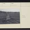
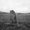
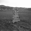
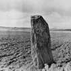
A standing stone 1.7m high by 0.9m broad and 0.3m thick, facing NW-SE and tilted to the NW. Except of a recent painted inscription the stone is unmarked.
Resurveyed at 1/2500
Visited by OS (J B) 23 June 1975
NH 532 483 A walkover survey was carried out in October 2000 on a proposed water pipeline renewal project extending from Brouallan to Muir of Ord Industrial Estate. No significant archaeological features were noted, though the proposed route passes close to the Scheduled standing stone at Windhill (NMRS NH54NW 10). Mitigation measures were recommended.
Report to be lodged with Highland SMR.
Sponsor: North of Scotland Water Authority.
J Wordsworth 2001
Field Visit (31 August 1943)
This site was recorded as part of the RCAHMS Emergency Survey, undertaken by Angus Graham and Vere Gordon Childe during World War 2. The project archive has been catalogued during 2013-2014 and the material, which includes notebooks, manuscripts, typescripts, plans and photographs, is now available online.
Information from RCAHMS (GF Geddes) 4 December 2014.
Field Visit (January 1978)
Windhill 2 NH 530 483 NH54NW 10
This standing stone is situated 360m NNW of Tomich House; it is 1. 7m high, 0.9m broad and 0.3m thick.
RCAHMS 1979, visited January 1978.


