 |
On-line Digital Images |
SC 1695114 |
RCAHMS Aerial Photography |
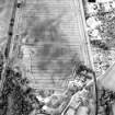
Oblique aerial view centred on the cropmarks of the enclosure, pit-alignment, linear cropmarks, pits and rig with standing stone adjacent, taken from the SSE. |
17/7/2000 |
Item Level |
|
 |
On-line Digital Images |
SC 1695115 |
RCAHMS Aerial Photography |
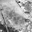
Oblique aerial view centred on the cropmarks of the enclosure, pit-alignment, linear cropmarks, pits and rig with standing stone adjacent, taken from the SSW. |
17/7/2000 |
Item Level |
|
|
Photographs and Off-line Digital Images |
SC 1921752 |
Cambridge University Collection for Aerial Photography |
|
16/7/1955 |
Item Level |
|
|
Photographs and Off-line Digital Images |
SC 1921753 |
Cambridge University Collection for Aerial Photography |
|
16/7/1955 |
Item Level |
|
 |
On-line Digital Images |
DP 340949 |
Papers of James Sloan Bone, landscape historian, Inverness, Highland, Scotland |
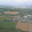
Aerial view of Muir of Ord, oblique view of industrial estate and part of Black Isle showground, looking NW. |
26/8/2007 |
Item Level |
|
 |
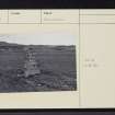
On-line Digital Images |
SC 2246264 |
|
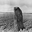
General view of standing stone from SE.
Original print bears annotation: 'No.4. Standing Stone on Road from Kilmorack to Tarradale. Taken about Noon April 1895. A.F.Yule". |
4/1895 |
Item Level |
|
 |
On-line Digital Images |
SC 2362461 |
Records of the Ordnance Survey, Southampton, Hampshire, England |
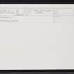
Windhill, NH54NW 10, Ordnance Survey index card, Recto |
c. 1958 |
Item Level |
|
 |
On-line Digital Images |
SC 2362462 |
Records of the Ordnance Survey, Southampton, Hampshire, England |
Windhill, NH54NW 10, Ordnance Survey index card, Recto |
c. 1958 |
Item Level |
|
 |
On-line Digital Images |
SC 2362463 |
Records of the Ordnance Survey, Southampton, Hampshire, England |
Windhill, NH54NW 10, Ordnance Survey index card, Recto |
c. 1958 |
Item Level |
|
 |
On-line Digital Images |
SC 2362464 |
Records of the Ordnance Survey, Southampton, Hampshire, England |
Windhill, NH54NW 10, Ordnance Survey index card, Recto |
c. 1958 |
Item Level |
|
 |
On-line Digital Images |
SC 2362465 |
Records of the Ordnance Survey, Southampton, Hampshire, England |
Windhill, NH54NW 10, Ordnance Survey index card, Recto |
c. 1958 |
Item Level |
|
|
All Other |
551 166/1/1 |
Records of the Ordnance Survey, Southampton, Hampshire, England |
Archaeological site card index ('495' cards) |
1947 |
Sub-Group Level |
|


