
Bute, Ardmaleish


Building(S) (Period Unassigned), Cultivation Remains (Period Unassigned)
Site Name Bute, Ardmaleish
Classification Building(S) (Period Unassigned), Cultivation Remains (Period Unassigned)
Alternative Name(s) Craiganlarich
Canmore ID 124773
Site Number NS06NE 43
NGR NS 06827 68785
Datum OSGB36 - NGR
Permalink http://canmore.org.uk/site/124773


- Council Argyll And Bute
- Parish North Bute
- Former Region Strathclyde
- Former District Argyll And Bute
- Former County Buteshire
NS06NE 43 06827 68785.
NS 068 687. Craiganlarich, three buildings, field system.
Sponsor: Buteshire Natural History Society
A Hannah and E Proudfoot 1996
NS 0680 6872 Site 133 Craiganlarich
In the west lee of a volcanic outcrop is a conspicuously green are of short grass and bracken with many stone and turf dykes and the remains of two buildings. These survive as rather slight sub-rectangular earth banked wall footings, 13x5m and 8x5m respectively. 50m north of these is a semi-circular structure, perhaps a pen, built against a dyke. No settlement is documented in this area, but the name Craiganlarich, given by May to the outcropping ridge, probably signified a site of former habitation.
Proudfoot and Hannah 2000
Craiganlarich
NS 0680 6872 Settlement remains: Located in W lee of ridge formed by volcanic dyke, southward of summit. The area is distinguished by green turf in brown moor. This is an area of short grass and bracken with many dykes and 3 buildings. There are banked wall-footings of large sub-rectangular buildings, 8 x 5m, just N. 50m further N a semi-circular structure is built against dyke. Field system of dyked enclosures. No record, except the name 'Craiganlarich' on May's map (1780/81), signifying a former house site.
Information from Bute Natural History Society Deserted Settlement Survey (1991-9)
(RCAHMS WP000273)
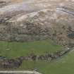
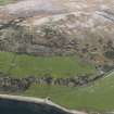
A farmstead, which comprises at least two buildings, stands within a multiperiod landscape of rig-and-furrow, field banks and enclosures in rough pasture 500m SW of Ardmaleish farmsteading. The best preserved building measures 10m from E to W by 4.3m transversely within walls reduced to grass-grown banks up to 1.7m in thickness and 0.2m in height. A second, more ephemeral building 6m to the N, measures 5.8m in length by 3.3m in breadth within walls reduced to banks 1.9m in thickness. What may me the vestiges of a third building are situated 15m SW of the first building.
A mid-18th century estate map (Foulis 1758-9) shows only 'moory pasture' in this area, while a later map (May 1780-82), although not depicting the farmstead itself, shows a dyke running along an exposed ridge of volcanic rock to the E. Blain's History of Bute describes how 'even on the height of the (Ardmaleish) farm considerable tracts of land fit for the plough are seen. In various places now covered with short heather the marks of arration (tillage) are now visible' (Ross 1880, 115).
Visited by RCAHMS (GFG, PJD), 21 April 2009.
Field Visit (1991 - 1999)
NS 068 687. Craiganlarich, three buildings, field system.
Sponsor: Buteshire Natural History Society
A Hannah and E Proudfoot 1996
NS 0680 6872 Site 133 Craiganlarich
In the west lee of a volcanic outcrop is a conspicuously green are of short grass and bracken with many stone and turf dykes and the remains of two buildings. These survive as rather slight sub-rectangular earth banked wall footings, 13x5m and 8x5m respectively. 50m north of these is a semi-circular structure, perhaps a pen, built against a dyke. No settlement is documented in this area, but the name Craiganlarich, given by May to the outcropping ridge, probably signified a site of former habitation.
Proudfoot and Hannah 2000
Craiganlarich
NS 0680 6872 Settlement remains: Located in W lee of ridge formed by volcanic dyke, southward of summit. The area is distinguished by green turf in brown moor. This is an area of short grass and bracken with many dykes and 3 buildings. There are banked wall-footings of large sub-rectangular buildings, 8 x 5m, just N. 50m further N a semi-circular structure is built against dyke. Field system of dyked enclosures. No record, except the name 'Craiganlarich' on May's map (1780/81), signifying a former house site.
Information from Bute Natural History Society Deserted Settlement Survey (1991-9)
(RCAHMS WP000273)
Field Visit (21 April 2009)
A farmstead, which comprises at least two buildings, stands within a multiperiod landscape of rig-and-furrow, field banks and enclosures in rough pasture 500m SW of Ardmaleish farmsteading. The best preserved building measures 10m from E to W by 4.3m transversely within walls reduced to grass-grown banks up to 1.7m in thickness and 0.2m in height. A second, more ephemeral building 6m to the N, measures 5.8m in length by 3.3m in breadth within walls reduced to banks 1.9m in thickness. What may me the vestiges of a third building are situated 15m SW of the first building.
A mid- 18th century estate map (Foulis 1758-9) shows only 'moory pasture' in this area, while a later map (May 1780-84), although not depicting the farmstead itself, shows a dyke running along an exposed ridge of volcanic rock to the E. Blain's History of Bute describes how 'even on the height of the (Ardmaleish) farm considerable tracts of land fit for the plough are seen. In various places now covered with short heather the marks of arration (tillage) are now visible' (Ross 1880, 115).
Visited by RCAHMS (GFG, PJD), 21 April 2009.
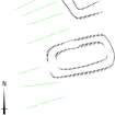
Measured Survey (31 March 2010)
RCAHMS surveyed the buildings and cultivation remains at Ardmaleish (Craiganlarich), Bute on 31 March 2010 with plane table and alidade at a scale of 1:100. The plan was redrawn in vector graphics software for publication at a scale of 1:500 (Geddes and Hale 2010, 35).

