Field Visit


Date 21 April 2009
Event ID 604825
Category Recording
Type Field Visit
Permalink http://canmore.org.uk/event/604825
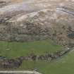
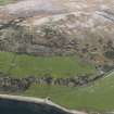
A farmstead, which comprises at least two buildings, stands within a multiperiod landscape of rig-and-furrow, field banks and enclosures in rough pasture 500m SW of Ardmaleish farmsteading. The best preserved building measures 10m from E to W by 4.3m transversely within walls reduced to grass-grown banks up to 1.7m in thickness and 0.2m in height. A second, more ephemeral building 6m to the N, measures 5.8m in length by 3.3m in breadth within walls reduced to banks 1.9m in thickness. What may me the vestiges of a third building are situated 15m SW of the first building.
A mid- 18th century estate map (Foulis 1758-9) shows only 'moory pasture' in this area, while a later map (May 1780-84), although not depicting the farmstead itself, shows a dyke running along an exposed ridge of volcanic rock to the E. Blain's History of Bute describes how 'even on the height of the (Ardmaleish) farm considerable tracts of land fit for the plough are seen. In various places now covered with short heather the marks of arration (tillage) are now visible' (Ross 1880, 115).
Visited by RCAHMS (GFG, PJD), 21 April 2009.