
Newhailes, Stables


Mews (19th Century), Stable(S) (18th Century), Structure (19th Century), Wall(S) (19th Century)
Site Name Newhailes, Stables
Classification Mews (19th Century), Stable(S) (18th Century), Structure (19th Century), Wall(S) (19th Century)
Alternative Name(s) Newhailes House; Garages
Canmore ID 122837
Site Number NT37SW 168.02
NGR NT 32555 72417
Datum OSGB36 - NGR
Permalink http://canmore.org.uk/site/122837


- Council East Lothian
- Parish Inveresk (East Lothian)
- Former Region Lothian
- Former District East Lothian
- Former County Midlothian
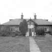
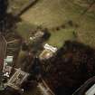
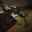
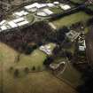
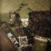
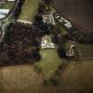
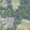
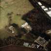
Situated to the south-west of Newhailes House, the stables & office block was built as part of the changes initiated on the estate in 1798 (with the north and east ranges constructed in 1826). They comprise a two storey quadrangular Classical stable court, incorporating late 17th century to mid-18th century builds in the north-west and south-west ranges. The north-west range is built of random rubble showing evidence of having been harled at an early point. The later classical north-east and south-east ranges are built of sandstone with ashlar joints. The hipped roofs are slated. The court is divided into three courtyards, with the main carriage pend entrance on south-east, and a further entrance on the south-west.
North Elevation
This elevation faces Newhailes House and is symmetrical with a central pediment on Doric pilasters and over two blind archways. The bays to either side have a plain base course, a profiled string course between ground and first floor and a corniced parapet well to the low pitched roof. There are two windrows to the ground and upper floor in each of the bays. The upper floor windows are glazed, and the ground floor windows glazed and blind. The composition is completed at either corner/end with square pilasters.
East Elevation
This elevation can be described as having two parts, the major part of which has a grander scale and is similar to the N elevation with its symmetry around the entrance to courtyard 1. This central main carriage entrance bay is pedimented, with double Doric pilasters flanking the pend archway. To either side of the entrance are wings with three windows (upper and lower), including blind windows as required by the internal room arrangement. The windows are similar to those on the N elevation. The composition is completed at either end with a single narrow bay flanked by pilasters. The bay contains a blind window at lower level and blank rectangular ashlar tablets at the upper and parapet levels. The base course, string course and parapet cornice are continuous from the N elevation.
The minor and southerly part is lower in height with lesser base course, string course and parapet cornice at a lower level to the main part. At the lower level there are three blind windows within recessed arches. At the upper level are blind windows, with no divisions, centred over the windows below.
South Elevation
This elevation comprises two buildings, the south west wing of the earlier north-west range and the E wing of the later range, separated by the entrance into courtyards 2 and 3.
The E wing elevation is not similar to its adjoining elevation described above. There is little symmetry to this elevation. The upper level has two single sash windows with astragals dividing the window into six equal panes. The lower level has a single doorway, two single sash 12 pane windows and two arched headed double doorways.
The earlier south-west wing is of random rubble and has a certain sparse symmetry with two single sash 6 pane windows at the upper floor level and four single doorways at ground floor level.
West Elevation
This elevation can be described as comprising of five sections.
The north most section forms part of the later range with its adornment restricted to the termination of the parapet cornice, base and string courses which have been returned round the comer from the N elevation. There is a centrally positioned sash window at the upper and lower levels.
The adjacent section marks the start of the earlier range of random rubble construction. The slated roof is of a noticeably steeper pitch than the north east range and the eaves level is lower. There is no symmetry to this section and openings have been positioned to suit the internal layout of rooms. There are three double sash windows at the upper level and two double sash windows at the lower level with a single doorway at both ends of this section.
The division between section 2 and 3 is delineated by a raking parapet, terminating at a two pot chimney stack at ridge level, and quoin stones marking the end of section 2.
Whilst the eaves level of section 3 is at the same level as that of section 2 the pitch of the roof changes to a shallower pitch. There are three openings at the upper level, a ventilation slot to either side of window positioned centrally on a doorway below. There are three openings at ground floor level, two small single doorways and one large single stable doorway for horse access. The random rubble is of a smaller stone size at the north end of the lower level.
Attached to this section is a single storey lean-to building of random rubble with raking parapet gable walls and a slated pitched roof with a single sky light. This building has one entrance on the north east elevation.
The division between section 3 and 4 is again marked by a raking parapet cope. The roof pitch and eaves level of section 4 matches that of section 3. There are three windows at the upper level, the north most of which is single pane whilst the other two are double sash windows. There is one doorway at ground floor level.
Section 5 is the hipped roof gable of the south west range. The roof pitch is similar to section 4 but the ridge and eaves are lower. The random rubble wall is completed with quoins. There are no openings on this section of the elevation.
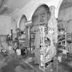
A major programme of monitoring, evaluation and architectural recording was undertaken at the stables during conservation works between June 2000 and August 2001, with additional monitoring taking place in 2008.
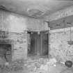
Evidence for its general evolution demonstrated that it had been successively extended from a core structure to the NW of the complex, reaching its present form in the first decades of the 19th century. The former contained the remains of an early bolection-moulded fireplace that matched details of ca. 1690 fireplaces in the mansion. While perhaps the fireplace had been reset, the chamfered window arises of this structure suggested a similarly early date.
The W and SW parts of the complex are rubble-built, employing salvaged stone from at least two earlier structures. One group of reused carved stones displays 17th-century or earlier detail in the form of chamfered arises and quirked edge rolls, while a second group derives from a classically designed building. The latter includes rusticated quoins and moulded cornice and base stones. The former may possibly provide evidence for a predecessor for the existing mansion while the latter may derive from alterations to the mansion itself or, perhaps, a further lost classical building within the policies; equally they may derive from the earlier configuration of the stables itself.
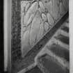
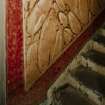
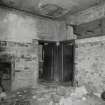
Various early floor levels were exposed within the ground-floor stables rooms - some brick-lined, some flagged and some cobbled. Earlier cobbling was also found with rooms occupying the E corner of the block, representing the remains of an exterior surface. Footings of an earlier range were found below floor level within the NW block of the existing structure, demonstrating that the interior court had been considerably smaller before c 1800. A number of ruined walls and lean-to structures within the courtyard were assessed and recorded. These proved to have been constructed in the later part of the 19th century.
Three evaluation trenches were excavated within the courtyard, to assess evidence for earlier surfaces and the potential for the survival of wall footings and other remains below these. A cobbled surface was identified, some 0.25m below the existing surface. Other than a rubble spread (demolition debris) no evidence for earlier structures was encountered below the cobbles. A miscellaneous find, of some importance, was recovered from one of the evaluation trenches placed within the courtyard; The artefact is carved from a soft blue-grey stone, possibly steatite, and measures 45mm in height, by 22mm at the top and 28mm at the base. It forms a tapering cylinder that appears to be slightly too irregular to have been lathe-turned. A 16mm wide socket had been cut down from the upper surface and this tapers towards the base, to a depth of 43mm.The base is highly polished and features a cartouche & hieroglyph with a close similarity to Tuthmosis (the Egyptian Pharoahs who reigned between ca. 1500-1400 BC).
(Information from the National Trust for Scotland January 2013)
NT37SW 168.02 32555 72417
NT 3269 7250 A major programme of monitoring, evaluation and architectural recording was undertaken at the mansion house and within its surrounding policies during conservation works between June 2000 and August 2001.
Stables. Extensive monitoring was carried out within and around the large stable block to the SW of the mansion house. Evidence for its general evolution demonstrated that it had been successively extended from a core structure to the NW of the complex, reaching its present form in the first decades of the 19th century. The former contained the remains of an early bolection-moulded fireplace that matched details of c 1690 fireplaces in the mansion. While perhaps the fireplace had been reset, the chamfered window arises of this structure suggested a similarly early date. The W and SW parts of the complex are rubble-built, employing salvaged stone from at least two earlier structures. One group of reused carved stones displays 17th-century or earlier detail in the form of chamfered arises and quirked edge rolls, while a second group derives from a classically designed building. The latter includes rusticated quoins and moulded cornice and base stones. The former may possibly provide evidence for a predecessor for the existing mansion while the latter may derive from alterations to the mansion itself or, perhaps, a further lost classical building within the policies; equally they may derive from the earlier configuration of the stables itself.
Various early floor levels were exposed within the ground-floor stables rooms - some brick-lined, some flagged and some cobbled. Earlier cobbling was also found with rooms occupying the E corner of the block, representing the remains of an exterior surface. Footings of an earlier range were found below floor level within the NW block of the existing structure, demonstrating that the interior court had been considerably smaller before c 1800. A number of ruined walls and lean-to structures within the courtyard were assessed and recorded. These proved to have been constructed in the later part of the 19th century.
Three evaluation trenches were excavated within the courtyard, to assess evidence for earlier surfaces and the potential for the survival of wall footings and other remains below these. A cobbled surface was identified, some 0.25m below the existing surface. Other than a rubble spread (demolition debris) no evidence for earlier structures was encountered below the cobbles.
Canal. Services trenching just beyond the N corner of the stables revealed parts of a brick-built retaining wall that defined the SW limit of a long ornamental canal, otherwise earth-banked and subsequently infilled. A NE return section of this wall had been constructed with an ornamental curving profile.
Water and drainage systems. General monitoring of services installation trenches exposed the well-preserved remains of an extensive network of stone-lined drains and water channels associated with the use of both the mansion house and stable block from the late 17th to the early 19th century.
Sponsor: National Trust for Scotland
T Addyman 2001
Photographic Survey (1 July 1959)
Photographic survey by the Scottish National Buildings Record in July 1959.
Watching Brief (December 2008)
An archaeological watching brief was required due to remedial work required on the stone slab floors of the Education Room (STG01) and Fruit Store (STG15) at Newhailes House Stables, Musselburgh (The room numbering is based on the site survey by LDN Architects in April 2008 Job number 0762 and follows the agreed room numbering system from the 1999 architectural survey). The site is located within the old stables block (north corner). The work consisted of a periodic watching brief with photographic recording and excavation to investigate any features that were exposed as part of the project and record the floor within the Education Room itself. These works were commissioned by Robin Turner, Head of Archaeology, The National Trust for Scotland. The work was undertaken in December 2008 and was restricted to the areas exposed by the contractor as part of the works on the floor.
Carried out by Connolly Heritage Consultancy
Watching Brief (January 2008 - March 2008)
NT 32570 72410 A watching brief was carried out, January– March 2008, during remedial work on the drainage system in the stables courtyard. Two drains of probable early 19th-century date were located and their routes traced. A small section of sandstone and mortar wall foundation with a pantile damp course relating to the earlier 18th-century stables was also uncovered.
Archive: RCAHMS
Funder: The National Trust for Scotland
David Connolly (Connolly Heritage Consultancy), 2008
Standing Building Recording (4 April 2017 - 11 April 2017)
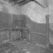
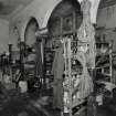
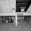
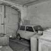
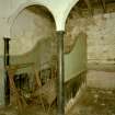
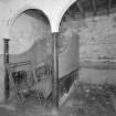
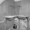
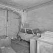
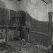
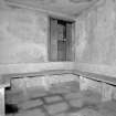
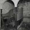
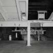
NT 32564 72411 A measured and building survey were undertaken, 4 – 11 April 2017, of the Newhailes Stables. The stables were constructed in the late 1790s and replaced earlier stables, which dated to the earlier 18th century. The stables initially consisted of a NE and SE wing, which was gradually expanded to the SW side to eventually become an enclosed courtyard structure, with a pend entrance to the SE elevation and another smaller entrance between the buildings to the SW. Today, the NE wing has been converted for both public use and for offices for the NTS staff, the remainder used as store rooms and gardeners’ stores. One of the wings to the NW of the complex has also been converted into a modern dwelling. Many of the original fixtures and fittings of the stables still exist, including horse stalls with trevisses and hay racks in situ, as well as tether rings and the original stone-flagged flooring. However, some areas, most notably the store rooms to the SW side, have been modified with inserted doorways into the partition walls and replacement concrete floors.
Archive: NRHE (intended)
Funder: National Trust for Scotland
Diana Sproat and Gemma Hudson – AOC Archaeology Group
(Source: DES Vol 19)
OASIS ID: aocarcha1-283472
Watching Brief (25 March 2019 - 5 November 2019)
NT 32560 72407 A watching brief was carried out at Newhailes Stables, Musselburgh, as part of the renovation of the stables buildings. Two main phases of groundbreaking works were monitored: the first oversaw the removal and reduction of the ground surface within the stable courtyard; the second involved monitoring the excavation of all sub-surface service routes, which included the installation of new drainage and lighting cabling. The work took place between March and November 2019.
The programme of works identified the fragmentary remains of the original 18th-century stable block, with substantial foundations recorded 0.35–0.4m below the surface, which align with the 1798 estate plan. The majority of the remaining features have been shown to relate to the mid/later 19th century, specifically the rectangular walled structure within the stable courtyard.
Archive: NRHE (intended). Reports lodged with East Lothian Council HER
Funder: National Trust for Scotland
John Musgrove − CFA Archaeology Ltd
(Source: DES Vol 21)
OASIS ID: cfaarcha1-375648 (J Musgrove) 2019

