
Dremergid


Cord Rig (Prehistoric), Hut Circle(S) (Prehistoric)
Site Name Dremergid
Classification Cord Rig (Prehistoric), Hut Circle(S) (Prehistoric)
Canmore ID 122418
Site Number NC70NW 18.01
NGR NC 7381 0657
Datum OSGB36 - NGR
Permalink http://canmore.org.uk/site/122418


- Council Highland
- Parish Rogart
- Former Region Highland
- Former District Sutherland
- Former County Sutherland
NC70NW 18.01 7381 0657
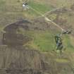
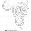
North of Dremergid are a large number of mounds and the remains of several hut circles. There is a complex comprising a hut circle (A), a circular enclosure (B), a horse-shoe shaped enclosure, and a series of banks (see plan). In the hut interior is a divisional wall and, abutting the W wall arc, a small enclosure. There is another horse-shoe shaped enclosure (published at NC 7381 0660) nearby.
RCAHMS 1911, visited 1909.
On a ridge are three hut circles (A-C) (hut C newly located at NC 7375 0661) and an accompanying field system. The complex of features is generally as planned by the RCAHMS:
Hut A, levelled back into a slight rise and heather and turf-covered, measures 13.0m in diameter within a wall up to 1.0m high and spread from 3.5m to 4.0m expanding to 5.0m in the sides of a splayed entrance in the SE. Inner-facing boulders show in the wall. Springing from the inside of the hut wall in the NE half, an arc of subsidiary walling, 2.0m broad by 0.4m high, forms a compartment 9.0m by 3.5m internally. The alleged enclosures against the W side is vague but the remainder of the interior is broken by loose and protruding stones suggesting footings of later bothy-type structures.
Hut B, levelled into the same slight rise at a marginally lower level, measures 11.0m in diameter within a heather-covered wall spread from 2.0m to 2.5m and up to 0.5m high; the ill-defined entrance is in the SE. The heather-covered bank or collapsed wall surrounding hut A is as planned by the RCAHMS; it appears to be contemporary with the hut, but its purpose is uncertain.
The horse-shoe shaped enclosure measures 14.5m across the open NE side by 13.0m transversely within a heather-covered bank, 3.0m broad by 0.4m maximum height, in which several boulders protrude. It is not a hut circle but a field plot. The similar enclosure at NC 7381 0660 measures 14.5m across the open W side by 11.0m transversely within a heather-covered, stony bank up to 4.5m broad by 0.6m high and is also a field plot.
Hut C measures 7.0m in diameter within a heather-covered wall, obscure in the NW sector but elsewhere 2.0m to 2.5m broad and up to 0.4m high. The entrance is not evident.
In comparing the three hut circles, 'A' stands out in presenting a markedly more robust build.
Revised at 1:10,000
Visited by OS (J M) 9 April 1981.
Field Visit (7 March 1995)
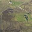
The footings of five hut-circles are disposed along the crest of the flat-topped ridge to the N of Dremergid.
At the S end of the group there is a crescentic setting of three hut-circles. The central house is a massive stone-walled structure (ROG95 3) measuring 12.5m in diameter within a boulder-faced bank 2.1m in thickness and 1.2m in height. The interior is dished and partially levelled into the gently-rising ground on the NW. The bank terminals on either side of the entrance, which is on the SSE, expand to about 5m in thickness. The thickening of the bank terminals is on the outside of the hut-circle, and appears to be secondary. A shallow penannular ditch, measuring about 2.4m across and 0.3m in depth, encloses the hut-circle, fading away to the E of the entrance, but with a terminal in line with the side of the entrance on the W. There is a narrow berm between the outer face of the hut-circle bank and the inner lip of the ditch, and a low upcast bank is visible outside the ditch. In the interior of the hut-circle there is a small oval hut and what may be a subrectangular structure. While the smaller hut appears to post-date the hut-circle, the relationship of the subrectangular structure to the hut-circle is not clear.
The ditch on the S side of the large hut-circle has been cut by a second hut-circle (ROG95 4) measuring 9.9m in diameter within a stony bank spread to 1.7m in thickness and 0.6m in height. To the NW the ditch is slighted by cord rig (NC70NW 18.03) which also runs up into the interior of a further hut-circle (ROG95 5) whose ESE side has been removed, but may have measured about 12.5m in diameter internally.
There are two further hut-circles (ROG95 6, 9) which appear to have been slighted in the same way, surviving as C-shaped arcs of bank, with smooth, presumably cultivated ground, in the interiors. These two structures would originally have been quite large, measuring about 13.8m by 11.7m (ROG95 6) and 12.5m in diameter (ROG95 9) internally.
(ROG95 3-6, 9)
Visited by RCAHMS (DCC) 7 March 1995
Measured Survey (12 May 1995)
RCAHMS surveyed the hut circles and cord rig at Dremergid on 12 May 1995 at a scale of 1:500. The resultant plan was redrawn in ink and published at a scale of 1:1000.

