
Torbreck Burn


Archaeological Landscape (Prehistoric) - (Post Medieval)
Site Name Torbreck Burn
Classification Archaeological Landscape (Prehistoric) - (Post Medieval)
Canmore ID 122385
Site Number NC70NW 4
NGR NC 7024 0628
Datum OSGB36 - NGR
Permalink http://canmore.org.uk/site/122385


- Council Highland
- Parish Rogart
- Former Region Highland
- Former District Sutherland
- Former County Sutherland
Field Visit (5 July 1995)
NC70NW 4.00 7024 0628
NC70NW 4.01 NC 7022 0622 Township; Corn-drying kilns (ROG95 342-4, 347-50, 378, 381-4, 386-97, 588, 591-9)
NC70NW 4.02 NC 7030 0642 Burnt mound (ROG95 379)
NC70NW 4.03 NC 7028 0638 Whisky Still (possible) (ROG95 385)
NC70NW 4.04 NC 7018 0636 and NC 7021 0634 Hut-circles (ROG95 345, 346)
NC70NW 4.05 NC 7020 0594 and NC 7020 0594 Hut-circles; Souterrain (possible)
(ROG95 589, 590)
NC70NW 4.06 NC 7056 0592 and NC 7060 0589 Buildings; Clearance (ROG95 399, 951)
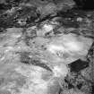
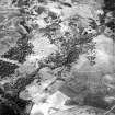
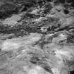
This township straddles two ridges lying to the W of the Torbreck Burn, and is surrounded by an earth-and-stone head-dyke, which encloses a mix of rough and ridged ground. The buildings and enclosures of the township are disposed in four loose groups (NC 70NW 4.01), around which there are areas of ridged ground (NC 70NW 4.02). What may be a still is levelled into the W bank of the Torbreck Burn (NC 70NW 4.03), while two buildings (NC 70NW 4.06) which may post-date the township are situated on a ridge to the SE. Earlier material is represented by four hut-circles (NC 70NE 4.04, 4.05), one of which may be associated with a souterrain, and a burnt mound (NC 70NW 4.07).
Visited by RCAHMS (DCC) 5 July 1995

