|
All Other |
MS 731/17 |
Records of the Royal Commission on the Ancient and Historical Monuments of Scotland (RCAHMS), Edinbu |
Afforestable Land Survey field database (Rogart survey, 1995). Held as attribute table in GIS and in Oracle Field/AP table. Please see DX001425 |
1995 |
Item Level |
|
|
Photographs and Off-line Digital Images |
C 46010 |
RCAHMS Aerial Photography |
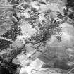
Torbreck Burn, Ardichoncherr, oblique aerial view, taken from the SE, centred on a township and rig, a hut-circle, enclosure, hut and small cairns. Further rig and small cairns are visible in the top half of the photograph, as is the edge of an area defined as ana rchaeological landscape. |
13/6/1995 |
Item Level |
|
|
Photographs and Off-line Digital Images |
C 46013 |
RCAHMS Aerial Photography |
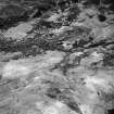
Torbreck Burn, Upper Morness, oblique aerial view, taken from the E, showing areas defined as archaeological landscapes in the centre and top half of the photograph. Various hut-circles, rig and small cairns are visible in the centre and top right-hand corner. |
13/6/1995 |
Item Level |
|
|
Photographs and Off-line Digital Images |
C 46014 |
RCAHMS Aerial Photography |
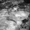
Torbreck Burn, oblique aerial view, taken from the E, showing areas defined as archaeological landscapes in the centre and top half of the photograph. A hut-circle, small cairns and rig are visible in the bottom left-hand corner area. |
13/6/1995 |
Item Level |
|
 |
On-line Digital Images |
SC 1692921 |
RCAHMS Aerial Photography |
Torbreck Burn, Ardichoncherr, oblique aerial view, taken from the SE, centred on a township and rig, a hut-circle, enclosure, hut and small cairns. Further rig and small cairns are visible in the top half of the photograph, as is the edge of an area defined as ana rchaeological landscape. |
13/6/1995 |
Item Level |
|
 |
On-line Digital Images |
SC 1692923 |
RCAHMS Aerial Photography |
Torbreck Burn, Upper Morness, oblique aerial view, taken from the E, showing areas defined as archaeological landscapes in the centre and top half of the photograph. Various hut-circles, rig and small cairns are visible in the centre and top right-hand corner. |
13/6/1995 |
Item Level |
|
 |
On-line Digital Images |
SC 1692924 |
RCAHMS Aerial Photography |
Torbreck Burn, oblique aerial view, taken from the E, showing areas defined as archaeological landscapes in the centre and top half of the photograph. A hut-circle, small cairns and rig are visible in the bottom left-hand corner area. |
13/6/1995 |
Item Level |
|
|
Digital Files (Non-image) |
DX 001425 |
Records of the Royal Commission on the Ancient and Historical Monuments of Scotland (RCAHMS), Edinbu |
RCAHMS Structures Database - Rogart |
1995 |
Item Level |
|
|
Digital Files (Non-image) |
TM 000355 |
Records of the Royal Commission on the Ancient and Historical Monuments of Scotland (RCAHMS), Edinbu |
Zip file containing all survey linework collected during the RCAHMS Afforestable Land Survey of the Rogart area 1995. |
1995 |
Item Level |
|
 |
On-line Digital Images |
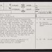
SC 2348478 |
Records of the Ordnance Survey, Southampton, Hampshire, England |
Torbreck Burn, NC70NW 4, Ordnance Survey index card, page number 1, Recto |
c. 1958 |
Item Level |
|
|
Digital Files (Non-image) |
TM 002205 |
Records of the Royal Commission on the Ancient and Historical Monuments of Scotland (RCAHMS), Edinbu |
Zip file containing all survey linework collected during the RCAHMS Afforestable Land Survey of the Rogart area 1995. SHP and Geojson file formats with extra attribution added to the linework. |
1995 |
Item Level |
|


