
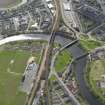
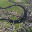
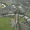
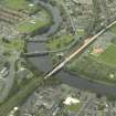
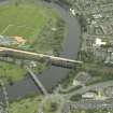
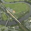
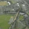
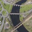
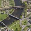
Stirling, Caledonian Railway Bridge


Railway Bridge (19th Century) - (20th Century)
Site Name Stirling, Caledonian Railway Bridge
Classification Railway Bridge (19th Century) - (20th Century)
Alternative Name(s) River Forth; Causewayhead
Canmore ID 121537
Site Number NS79SE 186
NGR NS 79820 94380
NGR Description NS 7980 9432 to NS 7984 9444
Datum OSGB36 - NGR
Permalink http://canmore.org.uk/site/121537


- Council Stirling
- Parish Stirling
- Former Region Central
- Former District Stirling
- Former County Stirlingshire
NS79SE 186 7980 9432 to 7984 9444
For North British Railway Bridge (adjacent to E), see NS79SE 223.
This bridge carries the railway lines heading NE from Stirling to Perth (Caledonian Rly.) and Alloa (North British Rly.) respectively across the River Forth, which here forms the boundary between the parishes of Stirling and Logie.
Information from RCAHMS (RJCM), 30 September 1997.
This bridge replaced an earlier wooden version built by the Scottish Central Railway Company and photographed by T Begbie c.1860.
Information by RCAHMS (DE), August 2001

