
Following the launch of trove.scot in February 2025 we are now planning the retiral of some of our webservices. Canmore will be switched off on 24th June 2025. Information about the closure can be found on the HES website: Retiral of HES web services | Historic Environment Scotland
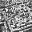
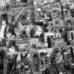
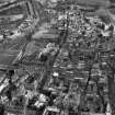
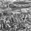
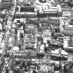
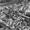
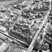
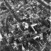
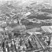
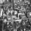
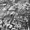
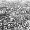
Edinburgh, South Bridge


Road Bridge (18th Century), Well (Period Unknown)(Possible)
Site Name Edinburgh, South Bridge
Classification Road Bridge (18th Century), Well (Period Unknown)(Possible)
Alternative Name(s) Cowgate; William Hunter And Company; Lawsons Photographic Gallery; Goodsons
Canmore ID 116664
Site Number NT27SE 1279
NGR NT 25980 73492
Datum OSGB36 - NGR
Permalink http://canmore.org.uk/site/116664


- Council Edinburgh, City Of
- Parish Edinburgh (Edinburgh, City Of)
- Former Region Lothian
- Former District City Of Edinburgh
- Former County Midlothian
NT27SE 1279 25980 73492
For North Bridge (continuation to N), see NT27SE 1278.
For (1996) watching brief at NT 2599 7345, see NT27SE 629.
See also under individual buildings.
South Bridge [NAT] (at NT 2598 7346)
OS (GIS) AIB, May 2006.
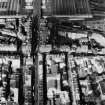
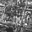
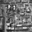
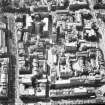
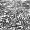
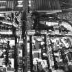
This bridge spans the Cowgate between a point near the E end of the High Street (to the N) and the junction with Chambers Street.
The location assigned to this record identifies the approximate midpoint of the structure. The available map evidence suggests that it extends from NT c. 25938 73651 to NT c. 25995 73434.
Information from RCAHMS (RJCM), 15 May 2006.
NT 260 735 SUAT Ltd conducted a watching brief at 253-255 Cowgate, Edinburgh during the replacing of the stone slab flooring. The site is situated within the vaults created during the construction of the South Bridge. Apart from a 'well' or sump which may predate the South Bridge, no archaeological remains were discovered under the old flooring. For safety reasons the feature was not investigated.
Sponsor: Mr Norrie Rowan
Kieran Haines, 2007
REFERENCE: NMRS HISTORICAL FILE
3 pages text describing Adam Square and building of South Bridge, plus details of information held by Edinburgh Dean of Guild on the creation of South Bridge -filed under "ADAM SQUARE";
3 pages text describing the erection of South Bridge and the effects on the surrounding area -filed under "SOUTH BRIDGE AND STREET"
REFERENCE: PLANS-CITY ARCHITECTS' PLAN STORE
Drawer No 39 contains a series of plans and elevations, some of a tentative nature. There are included:
a) Lithographed plan to smaal scale, probably that published by the City Authorities. Shows houses on the West side of Adam Square, with the name "Lord President", Marlins' and Peebles' Wynds are retained, and the Nochilson Column South of the Town Wall is shown;
b) A plan showing the Wynds and Closes affected by the buildings of the Bridge, and showing the Tron Church and Adam Square (1 photograph in NMRS);
c) A longitudinal section showing the lowering of the archways to suit the altered declivities -extending to beyond the Corinthian column of Lady Nicholson. Scale about 7 inches to 100 feet;
and the following elevations, which may be attributed to the Brothers Adam (Robert and James):
d) Two drawings showing alternative designs for the Cowgate Archway, to scale of 1 inch to 8 feet; and one drawing of the design chosen to scale of 1 inch to 4 feet;
e) A street elevation, part of the East side of the Bridge, coloured in monotone, to scale of 1 inch to 4 feet;
f) Elevation to the Cowgate referred to in articles of Roup of 18th April 1787, signed by J Hunter Blair and Francis Sharp. Scale 1 inch to 10 feet;
g) An elevation of Lot No 1 on the East side of the Bridge, docketted on back as of date 11th September 1787, and signed by John Grieve, Preses. Purports to be front to Niddry's Wynd but actually represents the High Street front, balancing that now existing (1948) of the building on the West side of Hunter Square. to the large scale of 4 inches to 10 feet;
h) Elevation of Lot 1st fronting Niddry Street. Scale nearly one and three quarter inches to 10 feet;
i) Elevation Lot 5th to Niddry Street. Scale nearly one and three quarter inches to 10 feet;
j) Elevation fronting College Street. Scale 1 inch to 10 feet;
k) A design for a bridge, dated 1770, marked as "transmitted to the Council with explanation" and signed by Da. Henderson. Conjectured as being in connection with the earlier proposals for bridging the valley, and that no buildings enclosing the sides had been then contemplated.
REFERENCE: NATIONAL LIBRARY OF SCOTLAND
Fettercairn Papers Acc. 4796, Box 124 -Papers concerning South Bridge Trustees 1789-1804.
REFERENCE: SCOTTISH RECORD OFFICE
RHP 5596 1801 Plan of middle flat of tavern and lower tier of vaults.
Building, etc Bridge over Cowgate. Heads of a bill for opening a communication with the town of Edinburgh.
1775 GD 18/5833
The building of a bridge and buildings between Lady Nicholson's Street and Tron Church. Letters, reports and estimates include Robert Adam's criticism and correction of the Trustees plan of Messrs Laurie and Kay.
1785-86 GD 18/5338
REFERENCE:
Sources: Dean of Guild Bundle 1813 January-June 13.5.1813
Pet. William Lamb, upholsterer
South Bridge
Alterations to ware room on ground floor
Plan. Unsigned
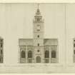
Edinburgh, South Bridge, British Linen Bank.
NMRS REFERENCE.
PLANS:
Dick Peddie and MacKay, Edinburgh, new.
Bin 28, Bag 2.
Dick Peddie and Walker Todd, 1927.
Edinburgh, South Bridge Street.
Sources: Dean of Guild. 16.6.1814
Pet. James and William Howden, Watchmakers and Jewellers.
No.9, South Bridge Street.
Minor alterations - interior.
Plans, unsigned.
Sources: Dean of Guild. 21.4.1814
Pet. Alexander Scott, farmer at Myreside.
No. 20 South Bridge Street - five warehouses above shops.
Minor alterations - interior.
2 Plans, before and after, unsigned.
Sources: Dean of Guild. 2.6.1814
Pet. Messrs MacKay and Cunningham - goldsmiths and jewellers.
No. 40 South Bridge.
Improvements to back shop.
Plan and elevation unsigned.
Sources: Dean of Guild. 31.3.1814
Pet. William Marshall, and Inc. of Goldsmiths.
No.98 South Bridge Street.
Alterations to South end - into a hall.
Plan and elevation signed. 16 March, 1814.
Wm. John Dickson and Co. 1810.
Sources: Dean of Guild. 10.3.1814
Pet. William Patison and Son, merchants.
South Bridge Street.
Shop front alterations.
Elevation of two floors, two doors and entry, unsigned.
NMRS REFERENCE:
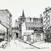
1 photograph of perspective view of South Bridge Street. copied from 'The Town and Country Almanack, Edinburgh, 1789. Original in Soane Museum.
Unable to locate at time of upgrade 15.2.2000.
(Undated) information in NMRS.
Construction (1785)
Project (2007)
This project was undertaken to input site information listed in 'Civil engineering heritage: Scotland - Lowlands and Borders' by R Paxton and J Shipway, 2007.
Publication Account (2007)
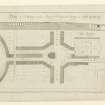
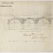
A development-led project designed by Robert Adam for the Town Council in ca.1785, eventually involving 20 arches, with adjoining high-quality buildings structurally independent of the bridge designed and built by Alexander Laing, architect and mason, from 1786–88. The bridge is built of masonry with semicircular arches, and vaults beneath most adjoining each storey, which are hidden except for the tallest crossing the Cowgate at about 31 ft which is also the widest at about 30 ft, most being about 18 ft. A section of 1790 from the Universal Scots Almanack and a modern drawing gives an idea of the project and the original North Bridge.
R Paxton and S Shipway 2007
Reproduced from 'Civil Engineering heritage: Scotland - Lowlands and Borders' with kind permission of Thomas Telford Publishers.
Standing Building Recording (August 2012)
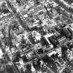
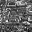
NT 2597 7343 The final stages of a programme of work, which commenced in June 2008, was undertaken at the fire damaged site of 233 Cowgate, the adjacent Hastie’s Close, 1–2 Chambers Street and South Bridge in August 2012. Stage 1 consisted of the production of detailed measured, written and photographic survey of the wall stubs remaining after the main demolition of the rest of the fire damaged buildings. The survey identified a number of original doorways and blocked openings together with some fireplaces, which formed the last remnants of the early 19th-century buildings. Stage 2 consisted of the recording of the interior of the remaining building at 1–2 Chambers Street to the S of the site. This building was originally constructed in the 1870s as a department store, and underwent renovations by new owners in the 1920s and 1930s. Stage 3 consisted of a watching brief in the Chambers Street building and additional recording work at Hastie’s Close.
Archive: RCAHMS (intended)
Funder: Sweett UK Ltd
Diana Sproat, AOC Archaeology Group
2012

