
Skye, Kyleakin, Caisteal Maol


Rune Inscribed Stone (Medieval), Tower House (Medieval)
Site Name Skye, Kyleakin, Caisteal Maol
Classification Rune Inscribed Stone (Medieval), Tower House (Medieval)
Alternative Name(s) Castle Moyle; Caisteal Moil; Maoile Castle
Canmore ID 11663
Site Number NG72NE 1
NGR NG 7580 2634
Datum OSGB36 - NGR
Permalink http://canmore.org.uk/site/11663


- Council Highland
- Parish Strath
- Former Region Highland
- Former District Skye And Lochalsh
- Former County Inverness-shire
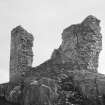
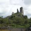
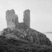
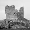
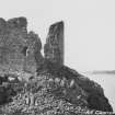
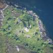
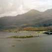
Castle Maol, 15th century The two-fingered ruin of a three-storey tower house, commanding Kyle Akin from a rocky knoll. Once a Mackinnon stronghold (formerly called Dunakin, after Haakon of Norway), it survives only on the south wall (with window embrasure), and parts of the west wall and north east corner. Abandoned in the early 17th century, it probably once resembled Caisteal Uisdean
Taken from "Western Seaboard: An Illustrated Architectural Guide", by Mary Miers, 2008. Published by the Rutland Press http://www.rias.org.uk

NG72NE 1 7580 2634
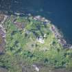
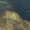
(NG 7580 2634) Caisteal Maol (NR) (In Ruins)
OS 6" map, Inverness-shire, 2nd ed., (1904)
Caisteal Maol ... a stronghold of the MacKinnons of Skye occupies a rocky promontory about 50ft OD.
The structure appears to be of 15th century date and is rectangular on plan measuring 46ft 6 ins by 34ft 8 ins externally with its major axis lying almost NE-SW. Only the N and S corners and the SE wall remain, being 8-9ft thick. They reach a height of 35-40ft outside and have contained three floors, with possibly a fourth within the roof. Debris completely fills the basement, but a corbel, projecting from the S wall at a level of 3ft below the step of the first floor window, indicates a bearer support for the floor. Evidently there have been no vaulted ceilings. The walls are of basalt rubble and are faced externally and internally with squared rubble built to courses of varying heights. At the base of the S wall there is a batten, which varies from 1ft 2 ins - 8ft on the splayed face, according to the irregular contour of the rock. No windows appear in the basement.
Dean Munro (1549) mentions "the castill of Dunna-Kyne, pertaining to MacKynnoun", which is clearly this place. It is marked on Blaeu's (i.e. Pont's) map under this name. In 1616 and 1627 Lauchlan MacKinnon of "Strathordill" had charters of these lands as a barony with the privilege of a ferry boat on the water of Kyleakin.
J Blaeu 1654; D MacGibbon and T Ross 1889; RCAHMS 1928.
Caisteal Maol, as described by RCAHMS, is in ruinous condition.
Visited by OS (A C) 13 June 1961.
No change.
Revised at 1/2500
Visited by OS (R L) 13 June 1961.
'Pine joist end': listed, no details given.
R Miket et al 1991.
Field Visit (25 June 1921)
Caisteal Maol.
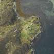
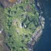
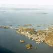
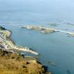
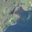
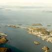
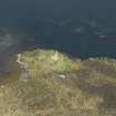
Situated less than ½ a mile due east of Kyleakin, and on the western shore of Loch Akin, Castle Maol, a stronghold of the Mackinnons of Skye, occupies the summit of a rocky promontory about 50 feet above sea-level. (Fig. 290.) The north and west sides of the height fall steeply to the water's edge, while the south and east sides drop precipitously over the rocks to a low-lying neck which isolates it from the mainland. The approach from all directions is difficult, but a pathway suggests itself as coming up the easiest natural slope at the north-west corner from the sea and seems to be governed by a cleft in the rock about 5 feet wide and 25 feet away from the castle.
The structure appears to be of 15th-century date and is rectangular on plan, measuring 46 feet 6 inches by 34 feet 8 inches externally with its major axis lying almost north-east and south-west. Only the northern and southern corners and the south-eastern wall remain, being 8 to 9 feet thick. They reach a height of 35 to 40 feet outside and have contained three floors, with possibly a fourth within the roof.
Debris completely fills the basement, but a corbel, projecting from the south wall at a level of 3 feet below the step of the first floor window, indicates a bearer support for the floor. Evidently there have been no vaulted ceilings.
The walls are of basalt rubble and are faced externally and internally with squared rubble built to courses of varying heights. Many of the facing stones are equal in breadth and height and many polygonal in form. The lime is made from coral. At base of the south wall there is a batter, which varies from 1 foot 2 inches to 8 feet on the splayed face, according to the irregular contour of the rock. No windows appear in the basement.
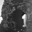
On the first floor, at the eastern end of the south wall, a window 2 feet by 2 feet is formed with square rybats. It has double sconsions, arched and opening to a width of 6 feet 9 inches in the interior. The rear arch is composed of thin stones on edge with a wedge-shaped keystone. Opposite on the north wall there seems to have been a similar window. No trace of door or stairway or other voids is seen.
A row of joist holes shows the second floor to have been about 10 feet higher than the first, and there is indication of a window over the one on this floor. Approximately another 10 feet above is a ledge, suggesting the third floor level, and the wall extends to a height of 4 or 5 feet above this.
HISTORICAL NOTE.
Dean Monro (1549) mentions ‘the castill of Dunnakyne, pertaining to Mackynnoun’, which is clearly this place. It is marked on Blaeu's (i.e. Pont's) map under this name. In 1616 and 1627 Lauchlan Mackinnon of ‘Strathordill’ had charters of these lands as a barony with the privilege of a ferryboat on the water of Kyleakin (1).
RCAHMS 1928, visited 25 June 1921.
OS map: Skye xli.
(1) R.M.S., s.a., Nos. 1514, 1183.
Note (7 December 2020)
A possible medieval rune inscribed stone has been identified by Mr M Smith at Caisteal Maol. Set into the E reveal of the surviving first-floor window opening, the stone measures about 35cm in width by about 25cm in height and bears more than 20 runes.
Information from HES Survey and Recording (GFG) 7 December 2020.

