
Skye, Kilbride, Clach Na H-annait


Standing Stone (Prehistoric)
Site Name Skye, Kilbride, Clach Na H-annait
Classification Standing Stone (Prehistoric)
Canmore ID 11449
Site Number NG52SE 2
NGR NG 5894 2030
Datum OSGB36 - NGR
Permalink http://canmore.org.uk/site/11449


- Council Highland
- Parish Strath
- Former Region Highland
- Former District Skye And Lochalsh
- Former County Inverness-shire
NG52SE 2 5894 2030
(NG 5894 2030) Clach Na H-Annait (NR)
OS 6"map, Inverness-shire, 2nd ed., (1903)
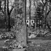
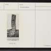
Clach na h-annait ('Stone of the Mother Church') is a standing stone, quadrangular in section for the greater part of its length, measuring 7ft 9ins in height above ground and 5ft 10ins in girth at base. Martin (1934) describes it as 10ft high and 1ft 6ins broad 1695. MacLeod (1912) and Donaldson (1923) say that a bell and stoup were found beneath this stone, but the Ordnance Survey Name Book (ONB, 1875) compiled five or six years after their discovery, states that they were dug up near the supposed walls of St Bridget's Chapel (q.v. NG52SE 3). The site of this chapel may have
been on a rocky mound about 25 yards SE of the stone, but all traces of the building have disappeared, and the exact site is not known.
Name Book 1875; F T MacLeod 1912; M E M Donaldson 1923; RCAHMS 1928; M Martin 1934.
Clach na h'Annait: a standing stone as described by RCAHMS. Around the base are a number of small stones, probably the result of field clearance.
Visited by OS (A C), 17 April 1961.
Field Visit (13 May 1914)
Standing Stone, Clach na h-Annait, Kilbride.
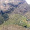
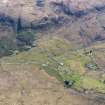
The stone known as Clach nah-Annait (‘Stone of the Mother Church’) is a fine monolith, quadrangular in section for the greater part of its length, measuring 7 feet 9 inches in height above ground and 5 feet 10 inches in girth at the base. It stands in a hollow in the middle of Strath Suardal, at an elevation of about 80 feet above sea-level, 100 yards almost west of Kilbride House and 4½miles south-west of Broadford. (Fig. 268.) Kilbride Church may have been on a rocky mound about 25 yards south-east of the stone, but all traces of the building have disappeared, and the exact site is not known.
RCAHMS 1928, visited 13 May 1914.
OS map: Skye xlvi.

