 |
On-line Digital Images |
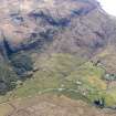
DP 109263 |
RCAHMS Aerial Photography Digital |
Oblique aerial view of the remains of the township, field system and cultivation remains at Kilbride, also showing the location of High Pasture Cave, Strath Suardal, Skye, taken from the NNE. |
30/4/2011 |
Item Level |
|
 |
On-line Digital Images |
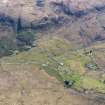
DP 109264 |
RCAHMS Aerial Photography Digital |
Oblique aerial view of the remains of the township of Kilbride and the nearby field system and cultivation remains, also showing the location of High Pasture Cave, Strath Suardal, Skye, taken from the N. |
30/4/2011 |
Item Level |
|
|
Photographs and Off-line Digital Images |
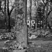
IN 556/1 |
Records of the Royal Commission on the Ancient and Historical Monuments of Scotland (RCAHMS), Edinbu |
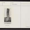
Standing stone, Clach na h-Annait. |
c. 1914 |
Item Level |
|
|
Photographs and Off-line Digital Images |
IN 556/2 |
Records of the Royal Commission on the Ancient and Historical Monuments of Scotland (RCAHMS), Edinbu |
Standing stone, Clach na h-Annait. |
c. 1914 |
Item Level |
|
 |
On-line Digital Images |
SC 1470391 |
Records of the Royal Commission on the Ancient and Historical Monuments of Scotland (RCAHMS), Edinbu |
Standing stone, Clach na h-Annait. |
c. 1914 |
Item Level |
|
 |
On-line Digital Images |
SC 2359770 |
Records of the Ordnance Survey, Southampton, Hampshire, England |
Skye, Kilbride, Clach Na H-Annait, NG52SE 2, Ordnance Survey index card, Recto |
c. 1958 |
Item Level |
|
 |
On-line Digital Images |
SC 2359771 |
Records of the Ordnance Survey, Southampton, Hampshire, England |
Skye, Kilbride, Clach Na H-Annait, NG52SE 2, Ordnance Survey index card, page number 1, Recto |
c. 1958 |
Item Level |
|
 |
On-line Digital Images |
SC 2359772 |
Records of the Ordnance Survey, Southampton, Hampshire, England |
Skye, Kilbride, Clach Na H-Annait, NG52SE 2, Ordnance Survey index card, page number 2, Verso |
c. 1958 |
Item Level |
|
 |
On-line Digital Images |
SC 2359773 |
Records of the Ordnance Survey, Southampton, Hampshire, England |
Skye, Kilbride, Clach Na H-Annait, NG52SE 2, Ordnance Survey index card, Recto |
c. 1958 |
Item Level |
|
|
All Other |
551 166/1/1 |
Records of the Ordnance Survey, Southampton, Hampshire, England |
Archaeological site card index ('495' cards) |
1947 |
Sub-Group Level |
|


