
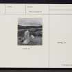
Skye, Clach Ard, Uig


Cairn (Prehistoric), Standing Stone (Prehistoric)
Site Name Skye, Clach Ard, Uig
Classification Cairn (Prehistoric), Standing Stone (Prehistoric)
Alternative Name(s) High Stone Of Uig
Canmore ID 11196
Site Number NG36SE 2
NGR NG 3943 6284
Datum OSGB36 - NGR
Permalink http://canmore.org.uk/site/11196


- Council Highland
- Parish Snizort
- Former Region Highland
- Former District Skye And Lochalsh
- Former County Inverness-shire
NG36SE 2 3943 6284.
(NG 3943 6284) Clach Ard.
Stone Circle (NR) (Remains of)
OS 6" map, Inverness-shire, 2nd ed., (1904)
Clach Ard is described by Martin (1934) as the 'High Stone of Uig' placed in the middle of a cairn. RCAHMS (1928) classify it as a standing stone (now fallen) lying on the summit of a stony mound resembling a denuded cairn. It is a four-sided prism tapering slightly towards one end measuring 5ft 2ins in length, 1ft 10ins in breadth and 1ft 5ins thick. About 7ft to the NE, are two rough boulders, 1ft 6ins apart, embedded in the ground.
Information from OS (A C) 22 March 1961.
(M Martin 1934; RCAHMS 1928).
Field Visit (30 May 1914)
Standing Stone, Clach Ard, Uig.
About 50 yards from the east side of the road from Portree to Uig, some 170 yards south-west of Uig School, on a slight eminence at an elevation of 300 feet above sea-level, is a prostrate pillar stone lying on the summit of a stony mound resembling a denuded cairn. The pillar is a four-sided prism tapering slightly towards one end and measures 5 feet 2 inches in length, 1 foot 10 inches in breadth, and 1 foot 5 inches in thickness. About 7 feet to the north-east are two rough boulders, 1 foot 6 inches apart, embedded in the ground, which measure 3 feet 4 inches and 3 feet 2 inches in length and 2 feet 3 inches and 2 feet 7 inches in breadth respectively.
RCAHMS 1928, visited 30 May 1914.
OS map: OS map: Skye xi (Stone Circle-remains of)
Field Visit (14 April 1961)
The standing stone, Clach Ard, has been re-erected and occupies a position just S of centre of a flat-topped cairn which is situated in a prominent position overlooking Uig Bay at a height of some 300ft OD.
The cairn measures 16.5m E-W, and 14.0m transversely; it is 0.8m high. Of the two rough boulders noted by RCAHMS only one remains.
Visited by OS (C F W) 14 April 1961.

