|
Manuscripts |
MS 1732/19 |
|
Third Edition Ordnance Survey monochrome 1-inch to 1 mile scale map, Sheet 80, annotated on the cover 'Skye'.
Used as Field Survey sheets with additional location and archeaological site annotation on the maps and includes sketches of the standing stone near the schoolhouse, Uig, Skye, dated 3 June 1921
Maps surveyed in 1875-76 and revised in 1904. |
1909 |
Item Level |
|
|
Manuscripts |
MS 36/68 |
Records of the Royal Commission on the Ancient and Historical Monuments of Scotland (RCAHMS), Edinbu |
Field notebook of C S T Calder (RCAHMS). Titled 'Skye and Lewis'. |
27/5/1921 |
Item Level |
|
 |
On-line Digital Images |
SC 2359161 |
Records of the Ordnance Survey, Southampton, Hampshire, England |
Skye, Clach Ard, Uig, NG36SE 2, Ordnance Survey index card, Recto |
c. 1958 |
Item Level |
|
 |
On-line Digital Images |
SC 2359162 |
Records of the Ordnance Survey, Southampton, Hampshire, England |
Skye, Clach Ard, Uig, NG36SE 2, Ordnance Survey index card, page number 1, Recto |
c. 1958 |
Item Level |
|
 |
On-line Digital Images |
SC 2359163 |
Records of the Ordnance Survey, Southampton, Hampshire, England |
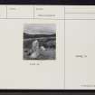
Skye, Clach Ard, Uig, NG36SE 2, Ordnance Survey index card, page number 2, Verso |
c. 1958 |
Item Level |
|
 |
On-line Digital Images |
SC 2359164 |
Records of the Ordnance Survey, Southampton, Hampshire, England |
Skye, Clach Ard, Uig, NG36SE 2, Ordnance Survey index card, Recto |
c. 1958 |
Item Level |
|
|
All Other |
551 166/1/1 |
Records of the Ordnance Survey, Southampton, Hampshire, England |
Archaeological site card index ('495' cards) |
1947 |
Sub-Group Level |
|


