
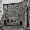
Bute, Rothesay, Castle Street, Town Hall And Sheriff Court


Drain(S) (18th Century) - (19th Century), Local Government Office (19th Century), Pit(S) (Medieval), Prison (19th Century), Sheriff Courthouse (20th Century), Town Hall (19th Century), Wall(S) (19th Century), Jug (Medieval), Unidentified Pottery (Medieval)
Site Name Bute, Rothesay, Castle Street, Town Hall And Sheriff Court
Classification Drain(S) (18th Century) - (19th Century), Local Government Office (19th Century), Pit(S) (Medieval), Prison (19th Century), Sheriff Courthouse (20th Century), Town Hall (19th Century), Wall(S) (19th Century), Jug (Medieval), Unidentified Pottery (Medieval)
Alternative Name(s) Castlehill Street; Town House; County Hall; County Buildings; Tolbooth
Canmore ID 111545
Site Number NS06SE 87
NGR NS 08864 64588
Datum OSGB36 - NGR
Permalink http://canmore.org.uk/site/111545


- Council Argyll And Bute
- Parish Rothesay
- Former Region Strathclyde
- Former District Argyll And Bute
- Former County Buteshire
NS06SE 87 08864 65488
NS 088 646 A watching brief was undertaken in January 2003 at the Town Hall and County Buildings, on the corner of Castle Street and High Street and immediately to the E of Rothesay Castle. The Town Hall and County Buildings are of 19th-century date, but are on the site of successive earlier tolbooths. The watching brief monitored the excavation of engineering trial pits and boreholes, but no significant archaeological remains were encountered.
Archive to be deposited in WoSAS SMR and the NMRS.
Sponsor: Structural Partnership.
C Dalglish 2003
NS 088 645 A programme of archaeological investigative works was undertaken between 15-26 January 2007 in respect to a proposed residential development at Rothesay Council Buildings, Isle of Bute. These works were undertaken to provide provisional information to inform the development of mitigation of the impact on the archaeological remains during the proposed redevelopment works.
A sequence of eight test pits were excavated, six within the ground floor of the Rothesay Council Buildings and two within the external courtyard areas. Of these eight pits only two produced archaeology of note, Test Pits 2 and 4, the first of which contained two small sandstone walls, the second comprising a mortar floor. Medieval green glaze pottery was found on the upper surface of the floor.
A number of the pits indicated disturbance to their deposits to allow the insertion of 18th-century slabbed drains and 19th century salt glaze drains.
Report deposited with WoSAS and archive with RCAHMS.
Funder: Fyne Homes.
Rebecca Shaw, 2007.
NS 088 645 An archaeological excavation was undertaken between 2-6 July 2007 to establish the heights of two vault
crowns and several wall heads prior to the laying of a new floor and associated drainage in the room immediately to the S of the Great Hall of the Gatehouse of Rothesay Castle. These excavations revealed several phases of building activity, reduction and repair.
Phase 1 c1200 to 1230 Circular wall of enceinte in reddish pink sandstone constructed with an arched entry to the N.
Phase 2 c1266 to 1296 Addition of four circular towers and a gatehouse of at least two floors with a portcullis to the N.
Phase 3 c1488 to 1542 Addition of a much larger gatehouse to the N, incorporating much of the Phase 1 and 2 work.
Phase 4 c1659 to 1685 Demolition and burning by Cromwellian troops and the forces of the Earl of Argyll.
Phase 5 c1816 to 1818 Ruins excavated and gatehouse vault rebuilt by the 2nd Marquess of Bute.
Phase 6 1872 to 1879 Consolidation of existing tusked masonry and structure including removal of trees and vegetation
by the 3rd Marquess of Bute.
Phase 7 c1900 3rd Marquess of Bute 'reconstructs' the Great Hall.
A further vault crown was left unexcavated as it lay below the recommended 200mm depth of excavation below the existing floor level. Additionally, a section of wall head between the NW Tower and the Gatehouse was drawn, numbered and recorded photographically prior to reinstatement and re-pointing works.
Archive to be deposited with RCAHMS.
Funder: Historic Scotland.
Paul Fox, 2007.
Publication Account (1978)
The Tolbooth formerly stood at the junction of Castle Street and High Street. In 1687 a steeple was added to the Tolbooth at its west-most gable and in 1700 one of the booths on the ground floor was converted into a jail. On the first floor was 'part of a hall sufficiently spacious for the accommodation of the courts of judicature' (Ross, 1880, 305).
Information from ‘Historic Rothesay: The Archaeological Implications of Development’ (1978).
Publication Account (1996)
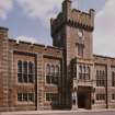
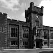
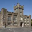
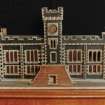
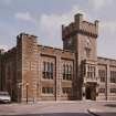
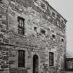
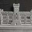
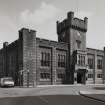
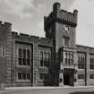
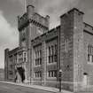
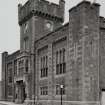
This building occupies an extensive site in the NE angle of High Street and Castle Street, bounded to the E by Watergate. It contains two principal storeys and is of inverted E-plan, with a 32.5m S front to Castle Street, shorter return wings to High Street and Watergate, and a central wing to the rear. It was built in 1833-5 in a castellated Gothic style, appropriate to its function as a jail and its location overlooking Rothesay Castle. This style was retained in alterations of 1865-7 and ofthe late 1880s, both of which included extensive additions to the rear. Its masonry is of brown ashlar with orange-yellow sandstone dressings.
The main front has slightly-projecting angle-towers and groups of triple-lancet transomed windows recessed between pilaster-buttresses which rise to a crenellated parapet. A five stage central clock-tower with corbelled parapet contains the ogee-headed entrance-doorway. This is now at ground-floor level, but originally a double forestair rose to a first-floor entrance which in the 1880s was replaced by an oriel-window within a corbelled and crenellated balcony.
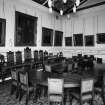
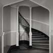
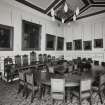
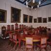
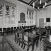
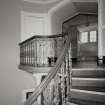
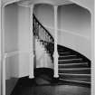
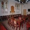
In the original arrangement the whole of the ground floor was devoted to prison-accommodation, with the jailer's house and further cells in the rear wing. The first floor housed 'a spacious court room in which the Sheriff, Burgh and Justice of the Peace courts are held, with the Town and Sheriff Clerks' offices, and other requisite apartments'. Extensive alterations were made following the closure of the jail in 1883, and the oval staircase to the rear of the entrance-tower is probably of that period. The building has undergone further alterations for use as local-government offices, but the Sheriff court-room retains its original position in the E part of the first floor, and to the W there is an imposing council-chamber with portraits of local notables.
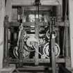
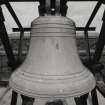
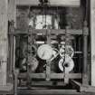
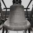
The tower houses the original clock-mechanism, which was donated by the 2nd Marquis of Bute and made by Arnold, Dent and Co. of London in 1834. The bell was cast in the same year by Stephen Miller and Co. of Glasgow, and stands in its original position on the roof of the tower.
HISTORY
At least two previous tolbooths stood on the site of the present building, the first of them supposedly on the W side of Watergate. This was replaced in 1614 by a tolbooth in Castle Street, at the SW angle of the present site. A 'belhous' was added to this building in 1688, and an engraving of about this period shows a bird-cage bellcot surmounting the W gable above a first-floor doorway reached by a forestair. It underwent frequent alterations during the late 17th and 18th centuries, and was demolished in 1834.
In 1831 an Act of Parliament was obtained for improving Rothesay harbour and 'for building a Gaol, Court House, and Offices for the said Burgh and County'. Even before the act was passed, the Duke of Hamilton, proprietor of Arran, protested that the proposed buildings were 'much too expensive', and forwarded plans of the County Buildings at Kinross as a more suitable model. The present building was designed by lames Dempster, a Greenock architect, and the foundation stone was laid in 1833, when a contract was made with a group of local tradesmen. Work began in the E half of the site, allowing the retention of the old town-house until part of the building was completed. The contract price was almost £2,800, but the final cost was about £4,000.
Information from ‘Tolbooths and Town-Houses: Civic Architecture in Scotland to 1833’ (1996).
Archaeological Evaluation (15 January 2007 - 26 January 2007)
NS 088 645 A programme of archaeological investigative works was undertaken between 15-26 January 2007 in respect to a proposed residential development at Rothesay Council Buildings, Isle of Bute. These works were undertaken to provide provisional information to inform the development of mitigation of the impact on the archaeological remains during the proposed redevelopment works.
A sequence of eight test pits were excavated, six within the ground floor of the Rothesay Council Buildings and two within the external courtyard areas. Of these eight pits only two produced archaeology of note, Test Pits 2 and 4, the first of which contained two small sandstone walls, the second comprising a mortar floor. Medieval green glaze pottery was found on the upper surface of the floor.
A number of the pits indicated disturbance to their deposits to allow the insertion of 18th-century slabbed drains and 19th century salt glaze drains.
Report deposited with WoSAS and archive with RCAHMS.
Funder: Fyne Homes.
Excavation (2 July 2007 - 6 July 2007)
NS 088 645 An archaeological excavation was undertaken between 2-6 July 2007 to establish the heights of two vault crowns and several wall heads prior to the laying of a new floor and associated drainage in the room immediately to the S of the Great Hall of the Gatehouse of Rothesay Castle. These excavations revealed several phases of building activity, reduction and repair.
Phase 1 c1200 to 1230 Circular wall of enceinte in reddish pink sandstone constructed with an arched entry to the N.
Phase 2 c1266 to 1296 Addition of four circular towers and a gatehouse of at least two floors with a portcullis to the N.
Phase 3 c1488 to 1542 Addition of a much larger gatehouse to the N, incorporating much of the Phase 1 and 2 work.
Phase 4 c1659 to 1685 Demolition and burning by Cromwellian troops and the forces of the Earl of Argyll.
Phase 5 c1816 to 1818 Ruins excavated and gatehouse vault rebuilt by the 2nd Marquess of Bute.
Phase 6 1872 to 1879 Consolidation of existing tusked masonry and structure including removal of trees and vegetation by the 3rd Marquess of Bute.
Phase 7 c1900 3rd Marquess of Bute 'reconstructs' the Great Hall.
A further vault crown was left unexcavated as it lay below the recommended 200mm depth of excavation below the existing floor level. Additionally, a section of wall head between the NW Tower and the Gatehouse was drawn, numbered and recorded photographically prior to reinstatement and re-pointing works.
P Fox 2007
Sponsor: Historic Scotland
Kirkdale Archaeology
Excavation (25 August 2008 - 30 September 2008)
NS 0886 6458 Monitoring of the final stages of demolition work and the removal of foundations took place 25 August–30 September 2008. During the removal of the foundations the site was reduced to a depth of between 0.8–1.2m. Two test pits were machine excavated to explore the potential for archaeology at greater depth. The first significant archaeological horizon found consisted of various pits, some of substantial size and depth. From these pits were recovered fragments of ceramic and metal work which could be provisionally dated to the 13th or 14th centuries. A face mask jug was also recovered from this level. A second significant archaeological horizon was located sloping down from the SW corner of the site to the NE. Fragments of medieval ceramic were recovered from this layer but no structural remains or features were observed.
Archive: RCAHMS. Report: WoSAS SMR
Funder: Fyne Homes
Alan Matthews, Kevin Paton and Claire Williamson – Rathmell Archaeology Limited
Characterisation (11 August 2010)
This site falls within the Rothesay Town Centre Area of Townscape Character which was defined as part of the Rothesay Urban Survey Project, 2010. The text below relates to the whole area.
Historical Development and Topography
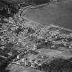
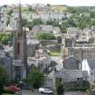
The Town Centre Area of Townscape Character comprises the main historical core of Rothesay, which grew up around the 13th-century castle, unique to Scotland in its circular form. From these early beginnings, Rothesay became a Royal Burgh in either 1400 or 1401 – the exact year is not entirely clear from documentary evidence. The castle was much altered during the following centuries, and the town itself expanded along the High Street towards 16th century St Mary’s Chapel to the south and the shore/Harbour in the north, in a traditional linear burgh form.
In the late 17th century (c.1680), the Marquess of Bute established a residence in the town, looking onto the Castle from the High Street. It was the second Marquis of Bute who, in 1816-18, carried out the first of many restorations to the castle. The town gradually spread out from the High Street during the 17th and 18th centuries. By the mid-18th century, the town stretched as far east as Bishop Street, as far south as Minister’s Brae and as far west as Mill Lade.
Two phases of land reclamation changed the focus and whole axis of Rothesay from north-south along the High Street to east-west along Montague Street in the mid- to late 18th century, and subsequently Victoria Street in 1839-40, which was built on the site of a former boatyard. The majority of the town centre was redeveloped as a result of these reclamation schemes, with key public buildings locating here in the 19th century, such as the court house on Castle Street built to designs by James Dempster in 1832 with later 19th century alterations, and the Baroque-style post office on Bishop Street, dated 1896. The harbour and pier grew in significance as a result of this shift, and its growth, along with the great rise in Rothesay’s popularity as a seaside tourist resort during the 19th century, saw the shoreline become the focus for the town’s growth rather than further inland.
On the whole, the town centre developed in a fairly ad hoc manner, as would be expected in a historic town centre. However, the area is largely a mid- to late 19th century Victorian creation, particularly with the reclamation of land along the shore, creating the Esplanade, with the later addition of the Winter Gardens, by Walter MacFarlane & Co’s Saracen Foundry in collaboration with the Burgh Surveyor, Alexander Stephen in 1923-4.
Numerous hotels were established here in the mid-19th century: Victoria, which has its original lamp standards and decorative floor tiling at the entrance; Esplanade, with double-height box bay window to Victoria Street and single-height to Guildford Square; Royal, has marbled columns flanking its entrance on Albert Place; Bute House, retains a timber Victorian shop front at ground floor with arched windows and entrance on curved corner; and Guildford Court, which has a modern flat-roofed canopy resting on original decorative cast-iron brackets over its entrance on Guildford Square. Several tenements were built along Victoria Street, Albert Street, East and West Princes Street. As a result of the numerous multiple occupancy buildings, the Town Centre Area of Townscape Character is a high density area, with mostly small plot sizes throughout.
Historically, as with most town centres, the area has been continuously redeveloped and infilled as the needs of the population grew and changed. The area around the Castle has probably seen the greatest deal of redevelopment in the 20th century, with the west and south sides surrounding it being wholly redeveloped with the building of Bute Museum in 1925-6 to designs by local architect Andrew Morell McKinlay, telephone exchange built in 1966 by John R Hunter (Building Contractors) Ltd, leisure centre and library designed by Robert B Rankin & Associates in the 1970s and job centre and Inland Revenue office also built in the 1970s. Guildford Square was created as a public open space following the demolition of two banks and a hotel in the 1990s.
Present Character
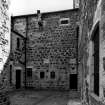
There are examples of each stage of Rothesay’s growth and development throughout the Town Centre Area of Townscape Character. Rothesay’s earliest beginnings are represented by the 13th century Castle. The 17th century Bute townhouse, with its crowstepped gables and projecting stair tower, is a fine survival of typical Scottish burgh architecture dating from this period. Much of the street layout in the area has survived unaltered despite later developments.
There are undoubtedly some remnants of 18th century buildings in the Watergate and Store Lane area, probably previously associated with former harbour activities. Some early 19th century single-storey-plus-attic cottages survive, much-altered, at Nos 19-27 Bishop Street, but the majority of the area dates from the huge Victorian expansion to provide tenement and hotel accommodation for the influx of tourists from the mid-19th century.
Many of the tenements built in Rothesay during the tourism boom display features similar in style to those tenements of the town’s middle-class Glaswegian visitors. The use of the same red sandstone, often with carved stonework including shaped pediments above entrance doors to shared tiled stairwells or ‘wally closes’ with decorative cast-iron balustrades and often stained glass windows to internal doors.
One of the key features of the Town Centre Area of Townscape Character is the extensive use of splayed corners to those 19th century buildings on street corners nearest to, or having views towards, the shore. This not only opens up and provides views to the sea for as many areas of the buildings as possible, but also maximises light into the buildings in what is a fairly densely packed urban fabric. The extensive use of bay windows, particularly along shoreline tenements on East Princes Street and Argyle Street, serves the same purpose, as elsewhere in Rothesay.
While most of the buildings, especially the tenements, are of a typically Scottish form, there are some more unusual or distinctive building styles dotted across the area. One example is James Hamilton & Son’s French Baroque-style Duncan’s Halls, built in 1876-9 at Nos 19-25 East Princes Street to provide a range of public halls and rooms for entertainment, and housing the town’s Palace Cinema from 1913 to 1963 when it became a bingo hall. James Dempster’s 1832 court house building on Castle Street is distinctive with its heavily battlemented parapet and chunky stonework, in contrast to the finer stonework of the surrounding tenements.
Throughout the Town Centre Area of Townscape Character Victorian cast-iron lamp posts, painted blue, with the town coat of arms still remain, though some may have been reinstated. These lamp posts can be found along the main seafront of the town, into the East Bay Area of Townscape Character and Serpentine and West Bay Area of Townscape Character.
Rothesay town centre contains a wide range of shop front styles, with many still surviving from its Victorian heyday. These consist of timber-framed shop windows and fascias above, often with moulded/carved columns and pilasters between window panes. In general these shop fronts also retain their original mosaic tiled lobbies within their recessed entrances. Rothesay also retains a fine example of corporate shop front design with the former Woolworths building at Nos 85-99 Montague Street, designed by B C Donaldson of London. Built in 1938, the store was designed to a pattern to ensure shoppers recognised the store as a modern Woolworth’s shopping experience at first sight. The shop front retains its traditional wooden-framed swing doors to its entrance, and demonstrates typical features of 1930s architecture, with a stepped roofline to the front elevation, and slightly projecting vertical stonework between windows at upper floors giving height to the building. Built in 1979, No 41-45 Montague Street (currently Lloyds TSB) is an unusual design by Roxby, Park & Baird consisting of a series of elements from Scottish architecture such as crowsteps, corbelling and a harled and whitewashed finish.
More modern features can be found in some distinctive 1960s/1970s tiling to a number of shop fronts in Montague Street and High Street. The manufacturer of these tiles has not yet been indentified, but they may be of local origin or bulk purchased by shopfitters working in the town.
Information from RCAHMS (LK), 11th August 2010

