
Rum, Kilmory, St Mary's Church Burial Ground


Burial Ground (Medieval), Church (Medieval)
Site Name Rum, Kilmory, St Mary's Church Burial Ground
Classification Burial Ground (Medieval), Church (Medieval)
Alternative Name(s) Rhum
Canmore ID 10946
Site Number NG30SE 1
NGR NG 3613 0366
Datum OSGB36 - NGR
Permalink http://canmore.org.uk/site/10946


- Council Highland
- Parish Small Isles
- Former Region Highland
- Former District Lochaber
- Former County Inverness-shire
Kilmory: the main settlement area before the clearances of 1826-8, with remains of a village and old burial ground on the riverbank (NG30SE 1). Here lies a 7th/8th century sandstone shaft with a plain cross incised on one side, a 'marigold' cross on the other (NG30SE 1.1). No trace survives of the church mentioned by Martin Martin in 1694. Here also, where a nursery of birch and rowan, Scots pine, alder and hazel has matured, is the remains of the former laundry for Kinloch Castle, a good five miles out of sight of the castle and its guests (NG30SE 48).
Taken from "Western Seaboard: An Illustrated Architectural Guide", by Mary Miers, 2008. Published by the Rutland Press http://www.rias.org.uk

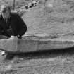
Kilmory, Rum, Skye & Lochalsh, cross-slab
Measurements: H 1.68m, W 0.26m tapering upwards to 0.13m, D 0.15m
Stone type: buff Torridonian sandstone
Place of discovery: NG 3613 0366
Present location: lying in the burial ground at Kilmory, on the west side of the Kilmory river.
Evidence for discovery: noted by Muir in the early 1880s already lying flat. The D-shaped burial ground has a raised interior, and there is a small stony mound nearby on which the slab may have stood.
Present condition: weathered.
Description
This tapering pillar is carved on both broad faces towards the top. On face A there is a cross-of-arcs within a circle, 0.19m in diameter, carved in low relief and defined by narrow roll mouldings. the circle is supported on a sunken shaft with an expanded top and triangular base. The stepped sunken base of a small incised Latin cross stands on top of the cross-of-arcs. On face C is a sunken Latin cross with a slightly expanded foot.
Date range: seventh or eighth century.
Primary references: Muir 1885, 83; Fisher 2001, 98-9.
Compiled by A Ritchie 2016
Field Visit (2 July 1925)
Church and Churchyard, Kilmory.
On the northern side of the island at the mouth of the Kilmory river are foundations of a township, and the land in the immediate neighbourhood shows signs of former cultivation. The church stands immediately north of the graveyard on rising ground at the foot of a little rocky cliff on the left bank of the river. It is a ruinous drystone structure measuring externally 38 ¾ feet from east to west by 19 ¼ feet. The walls are 3 ½ feet feet thick and are reduced to an average height of 4 feet. The western angles are rounded but the eastern are fairly rectangular. The entrance is in the south wall and is 3 foot 1 inch in width. No other openings are apparent. The churchyard is enclosed by a ruinous wall; it contains a number of plain unwrought head slabs and a shaft of hard sandstone, 4 ¾ foot in height and 9 inches in average width with a thickness of 6 inches, bearing at the top a small incised Latin cross surmounting a circular panel 8 inches in diameter, defined by two incised lines, which contains a cross with expanding arms set saltire-wise; towards the base of the shaft are two parallel incised lines.
RCAHMS 1928, visited 2 July 1925.
OS map: Islands of Rum, Sanday, etc., lx.
Reference (1963)
The settlement of Kilmory was evacuated in 1828 and the ruins of blackhouses exist today.
K Williamson and J M Boyd 1963
Field Visit (16 May 1972)
The building noted by the RCAHMS as St Mary's Church is still known locally by that name, but does not appear to be a church. It is a ruinous blackhouse oriented N-S, one of a group forming the depopulated hamlet of Kilmory. The RCAHMS's measurements are correct, but the doorway is in the centre of the E wall. The walls stand to the wall head. There is no building in the area oriented E-W and none that can be recognised as a church.
The burial ground, now disused, is an irregularly-shaped enclosure bounded by a dry wall in good state of repair. The cross-incised sandstone shaft lies prostrate in the E half and measures 1.6m long x 0.2m x 0.2m. The cross set saltire-wise within a circle is visible near the top and has an incised line running upwards and also down- wards from it. The two parallel lines are also visible. On the rear of the shaft near the top is another cross of latin style. Both crosses are very weathered, and are difficult to interpret.
Visited by OS (AA) 16 May 1972.
Desk Based Assessment (1972)
NG30SE 1 3613 0366.
(NG 3613 0366) Old Burial Ground (NAT)
OS 6" map (1903)
St Mary's Church stands immediately N of the graveyard and is a ruinous drystone building c. 39' E-W by 19' with 3 1/2' thick walls reduced to an average height of 4'. The S entrance is apparently the only one. The graveyard, enclosed by a ruined wall, contains, in addition to plain headstones, a shaft of hard sand- stone 4 3/4' long, bearing, at the top, and incised latin cross surmounting a circular panel 8" in diameter, which contains a cross with expanding arms set saltire-wise; towards the base of the cross are two parallel incised lines.
Information from OS c.1972
Source: RCAHMS 1928, visited 1925
Field Visit (June 1983)
A raised D-shaped enclosure (14.5m by 12.2m internally and revetted by a drystone wall) lies among the buildings of the deserted township no.30. The earliest inscribed monuments is of early 19th-century date, but a 7th- or 8th- century cross-marked pillar 1.6m long lies in the enclosure. It is carved in shallow relief on one face with a long-shafted four-petalled 'marigold' cross surmounted by an incised Latin cross, and on the other face with a sunken Latin cross. There are no visible remains of a chapel (the building recorded by RCAHMS in 1925 is part of the township) although a chapel on Rhum is mentioned by Martin at the end of the 17th century.
RCAHMS 1983 No. 17, visited June 1983.
Sources: RCAHMS 1928; M Martin 1934; J A Love 1983.
Field Visit (June 1983)
Kilmory, Burial-ground and Cross NG 361 036 NG30SE
A raised D-shaped enclosure (14.5m by 12.2m internally and revetted by a drystone wall) lies among the buildings of the deserted township NG30SE 8; The earliest inscribed monument is of early 19th-cehtury date, but a 7th- or 8th-century cross-marked pillar 1.6m long lies in the enclosure. It is carved in shallow relief on one face with a longshafted four-petalled 'marigold' cross surmounted by an incised Latin cross, and on the other face with a sunken Latin cross. There are no visible remains of a chapel (the building recorded by RCAHMS in 1925 is part of the township) although a chapel on Rhum is mentioned by Martin Martin at the end of the 17th century.
RCAHMS 1983, visited June 1983
(RCAHMS 1928, pp. 219-20, No. 687; Martin 1934, 299; Love 1983, 4, 5)
Field Visit (2006)
The burial ground is in the centre of the settlement (NG30SE 8) and is enclosed by a drystone wall topped by a post and wire fence. The fence posts have been set into stones within the wall but many of the stones and posts have now fallen and are no obstacle to access. There is no apparent
entrance to the burial ground through or over the wall; at present access is gained up the tumbled masonry at the NE corner.
The interior of the graveyard is generally at the same level as the top of the wall, which has several areas of collapse. The NE corner was mentioned as a problem at the time of the previous visit (13-May-95) and the condition has deteriorated and the area affected increased.
Although some tumble was noted on the SE corner, this has increased in area and severity. There is a large stone missing in the centre of the NW corner and it is likely that if work is not carried out on the whole wall in the near future the fabric of the burial ground will be permanently damaged. Ideally, the wall should be reinstated and possibly the post and wire
fence re-erected to control access by deer. The settlement is regularly visited by the public who also visit the burial ground and to ensure the survival of the wall and fence once it has been reinstated some form of stile should be provided to allow access.
Information from Ann Coombs and John Raven (Historic Scotland) 2006
Field Visit (21 July 2012)
NG 3613 0366 The stone dyke surrounding the burial ground at Kilmory is deteriorating and SNH plan to carry out restoration work and install steps into the burial ground. A desk-based assessment and survey were carried out on 21 July 2012 to identify known archaeological sites within the scheduled area and to prepare a detailed plan of the Kilmory settlement. The survey also assessed the current state of preservation of the wall enclosing the burial ground and any related features. The survey has provided baseline data on the preservation of the sites and has highlighted where further archaeological work may be required during the restoration.
The burial ground is an irregular raised area situated at the base of a rocky outcrop; structures that form part of the settlement lie to its north and east. It is completely surrounded by a stone dyke, which is generally in a good state of repair with the exception of three corners: the north-east corner has considerable wall tumble; the south-east corner has wall tumble, although to a lesser degree and the north-west corner shows signs of damage. There is no entrance, but it would appear that entry is being gained to the burial ground via the north- and south-east corners and erosion of the bank is evident at these locations.
A small cairn-like mound of stones, with a face of moss-covered stones on its east side, was located in the north-east corner of the burial ground.
Archive: RoCAS. Report: Highland HER
Funder: Scottish Natural Heritage
Lynn Fraser and Stephen Birch (Ross and Cromarty Archaeological Services) 21 July 2012: OASIS ID: rosscrom1-134370
Watching Brief (18 July 2013 - 30 July 2013)
NG 3610 0360 A watching brief was carried out by Emma Malone, 18–30 July 2013, during repair work and the construction of new steps to a dilapidated stone dyke surrounding Kilmory Cemetery. Sections of the wall have clearly been repaired and rebuilt many times, using different walling construction techniques. Three parts of the wall were identified as requiring repair due to collapse. Two fragments of human remains were revealed as a result of soil movement after the removal of collapsed stonework. These were photographed and replaced in the same area when the wall was reinstated.
Archive: HAS. Report: Highland HER
Funder: Scottish Natural Heritage
Lynne McKeggie, Highland Archaeology Services, 2013
(Source: DES)

