
Skye, Trumpan Mor


Township (Post Medieval)
Site Name Skye, Trumpan Mor
Classification Township (Post Medieval)
Alternative Name(s) Cnoc A'chatha, Skye
Canmore ID 10941
Site Number NG26SW 5
NGR NG 233 606
Datum OSGB36 - NGR
Permalink http://canmore.org.uk/site/10941


- Council Highland
- Parish Duirinish
- Former Region Highland
- Former District Skye And Lochalsh
- Former County Inverness-shire
Field Visit (4 May 1961)
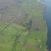
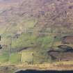
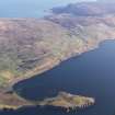
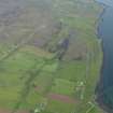
NG 233 609. About 230ft above sea-level on the W side of the road, S of Trumpan, is a depopulated township. There are about 15 ruined houses, some outbuildings, and 4 enclosures. There are large areas of lazy-beds to the S and E.
Visited by OS (ASP) 4 May 1961.
Field Visit (28 September 1990 - 18 November 1990)
NG26SW 5.00 233 606
The farm of Trumpan Mor is first mentioned in a rental of 1683 (R C Macleod 1928, Vol.I). In 1781 both Trumpan Mor and Trumpan Beg
were sold to Donald MacDonald of Balrauald (R C Macleod 1929, Vol.II). Its farmstead may be identified with a spread of structures on the NE side of Halistra Loch (a relatively recent creation) and adjacent to the public road centred on NG 2330 6085. To the N the township boundary is common with Trumpan Beg (NG26SW 11); the W is constrained by the coast; to the S the boundary is common with Halistra, defined by a bank along an unnamed burn which runs round to the E, enclosing an area of unridged, relatively blank land. In the E of the area thus defined, on a series of terraces running away to the E from the public road, are a scatter of farmsteads, beyond which is a scatter of shielings. The pattern of lazy-beds and globular fields is sometimes disrupted by more recent ploughing. There are at least two hut-circles, one of which is overlain by the township boundary and a number of banks and orthostatic walls beneath lazy-beds.
5.01 NG 23 60 Field Banks; Cultivation Remains
5.02 From NG 2365 6021 to 2327 6085; 233 609 Township (109-138, 189-212)
5.03 NG 2305 6067 Buildings (139-141)
5.04 NG 2345 6075 Buildings; Enclosure (188; 224-225)
5.05 NG 2396 6050 Building; Enclosure (213-214)
5.06 NG 2397 6065 Farmstead (215-217)
5.07 NG 2374 6069 Farmstead (218-220)
5.08 NG 2358 6075 Farmstead (221-223)
5.09 NG 2354 6103 Farmstead (1041-1044)
5.10 NG 2354 6060 Building (1485)
5.11 NG 2305 6020 Buildings; Enclosures; Boat Naust (Possible) (104-108)
5.12 NG 238 610 Shieling-huts; Shieling-mounds (1028-1040; 1045-1050)
5.13 NG 2377 6128 Building (1024)
5.14 NG 2380 6137 Hut-circle (possible) (1023)
5.15 NG 2372 6143 Farmstead; Huts; Stack-stands (1015-1022)
5.16 NG 2356 6157 Hut (1014)
5.17 NG 2356 6140 Buildings; Pond (Possible) (1025-1027)
5.18 NG 2387 6178 Shieling-hut (1009)
5.19 NG 2260 6067 Hut; Field Banks; Enclosure (Possible) (1091)
5.20 NG 2242 6086 Buildings; Enclosure (Possible) Field Banks (1092-1094)
5.21 NG 2290 6085 Buildings; Kiln-barn (1480-1484)
Visited by RCAHMS (DCC) 28/29 September 1990/18 November 1990.
Note (6 November 1996)
A township, comprising one roofed building and fifty-one unroofed buildings is depicted on the 1st edition of the OS 6-inch map (Inverness-shire, Isle of Skye 1881, sheet ix). Six roofed and forty-seven unroofed buildings are shown on the current edition of the OS 1:10560 map (1968).
Information from RCAHMS (AKK) 6 November 1996.

