|
Prints and Drawings |
DC 20890 |
Records of the Royal Commission on the Ancient and Historical Monuments of Scotland (RCAHMS), Edinbu |
Location map: Areas surveyed, Waternish, Skye. (PMT Copy). |
1990 |
Item Level |
|
|
Prints and Drawings |
DC 20891 |
Records of the Royal Commission on the Ancient and Historical Monuments of Scotland (RCAHMS), Edinbu |
Distribution map: Townships (c.1700), buildings, shieling mounds, Waternish, Skye. (PMT Copy). |
1990 |
Item Level |
|
|
Prints and Drawings |
DC 25549 |
Records of the Royal Commission on the Ancient and Historical Monuments of Scotland (RCAHMS), Edinbu |
Skye, Duirinish, Dun Hallin.
ALS Waternish survey working drawings |
1990 |
Item Level |
|
|
Manuscripts |
MS 731/2 |
Records of the Royal Commission on the Ancient and Historical Monuments of Scotland (RCAHMS), Edinbu |
Printout of RCAHMS ALS database for the Archaeological Survey of Waternish. |
1990 |
Item Level |
|
|
Prints and Drawings |
DC 20892 PO |
Records of the Royal Commission on the Ancient and Historical Monuments of Scotland (RCAHMS), Edinbu |
Skye, Duirinish, Dun Hallin.
Distribution map: Prehistoric, Waternish, Skye. (PMT Copy). |
1990 |
Item Level |
|
|
Prints and Drawings |
DC 26872 |
Records of the Royal Commission on the Ancient and Historical Monuments of Scotland (RCAHMS), Edinbu |
Composite plan of archaeological landscape along W side of Waternish Peninsula |
1991 |
Item Level |
|
|
Prints and Drawings |
DC 20896 PO |
Records of the Royal Commission on the Ancient and Historical Monuments of Scotland (RCAHMS), Edinbu |
Distribution map: Prehistoric, Waternish, Skye. (PMT Copy) |
1990 |
Item Level |
|
|
Prints and Drawings |
DC 26873 |
Records of the Royal Commission on the Ancient and Historical Monuments of Scotland (RCAHMS), Edinbu |
Plan of archaeological landscape, covering parts of NG2361 and NG2461 |
1991 |
Item Level |
|
|
Prints and Drawings |
DC 26874 |
Records of the Royal Commission on the Ancient and Historical Monuments of Scotland (RCAHMS), Edinbu |
Plan of archaeological landscape, covering part of NG2361 and NG2461 |
1991 |
Item Level |
|
|
Photographs and Off-line Digital Images |
C 93105 S |
Records of the Royal Commission on the Ancient and Historical Monuments of Scotland (RCAHMS), Edinbu |
Copied from RCAHMS (1993) "Waternish", p.16, plan 2. |
1993 |
Item Level |
|
 |
On-line Digital Images |
DP 076612 |
RCAHMS Aerial Photography Digital |
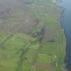
General oblique aerial view of Trumpan with Hallin beyond, taken from the NW. |
31/5/2009 |
Item Level |
|
 |
On-line Digital Images |
DP 076613 |
RCAHMS Aerial Photography Digital |
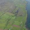
General oblique aerial view of Trumpan with Hallin beyond, taken from the WNW. |
31/5/2009 |
Item Level |
|
 |
On-line Digital Images |
DP 076614 |
RCAHMS Aerial Photography Digital |
General oblique aerial view of Trumpan with Hallin beyond, taken from the WNW. |
31/5/2009 |
Item Level |
|
 |
On-line Digital Images |
DP 111350 |
RCAHMS Aerial Photography Digital |
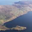
General oblique aerial view of Trumpan and the Waternish peninsula, Skye, taken from the W. |
16/11/2011 |
Item Level |
|
 |
On-line Digital Images |
DP 111352 |
RCAHMS Aerial Photography Digital |
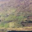
General oblique aerial view of the remains of the townships of Trumpan Mor, Trumpan Beg and the remains of the surrounding dykes and lazy beds, Waternish, Skye, taken from the SW. |
16/11/2011 |
Item Level |
|
 |
On-line Digital Images |
SC 2358617 |
Records of the Ordnance Survey, Southampton, Hampshire, England |
Skye, Trumpan Mor, NG26SW 5, Ordnance Survey index card, Recto |
c. 1958 |
Item Level |
|
 |
On-line Digital Images |
SC 2358618 |
Records of the Ordnance Survey, Southampton, Hampshire, England |
Skye, Trumpan Mor, NG26SW 5, Ordnance Survey index card, Recto |
c. 1958 |
Item Level |
|
|
All Other |
551 166/1/1 |
Records of the Ordnance Survey, Southampton, Hampshire, England |
Archaeological site card index ('495' cards) |
1947 |
Sub-Group Level |
|


