
Pricing Change
New pricing for orders of material from this site will come into place shortly. Charges for supply of digital images, digitisation on demand, prints and licensing will be altered.
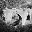
Dunans Bridge


Bridge (19th Century)
Site Name Dunans Bridge
Classification Bridge (19th Century)
Canmore ID 109038
Site Number NS09SW 16
NGR NS 04048 91254
Datum OSGB36 - NGR
Permalink http://canmore.org.uk/site/109038


- Council Argyll And Bute
- Parish Kilmodan
- Former Region Strathclyde
- Former District Argyll And Bute
- Former County Argyll
Bridge. Wide pointed arch flanked by narrower ones. Random rubble. Saddle-back coping. Polygonal buttresses. Insets with monogram and date over central arch. (Historic Scotland)
Field Visit (June 1988)
This bridge spanning the gorge of the River Ruel carries the access-road from the A886 highway to Dunans House, home of the Fletcher family since the 18th century. The house itself was rebuilt in baronial style c.l880 (en.1*), but the bridge bears the date 1815 and the initials of John Fletcher (d.l822).
The bridge, which is built of local schist rubble with a sandstone coping, is 16.3m in overall height, and the level roadway is 28m in length and 5.4m in width within 0.5m parapets. It comprises three tall two-centred arches, the middle one spanning the river and the others carrying the approaches above the steep banks of the gorge. The central arch, which has centering-sockets below springing-level, is7.85m in span and 13.3m in height, and the side-arches are3.7m in span. All three arches spring from octagonal abutment-piers, decorated with blind slits, which project into the roadway. The arch-springings are marked by projecting impost-bands, returned along the arch-soffits, and similar bands mark the bases of the parapets. On each side the parapet is stepped up at the centre to enclose a sandstone panel bearing the initials JF, and in the N panel the date 1815, and below these panels there are drain-spouts, that to the Sin the form of a human gargoyle, while the other arches have corresponding spouts. A winding path downstream on the W bank gives a view of the bridge, which was improved by two artificial cascades.
RCAHMS 1992, visited June 1988
Measured Survey (8 June 1988)
RCAHMS surveyed Dununs Bridge, Glendaruel on 8 June 1988 producing a plan and west elevation at a scale of 1:100. The plan and elevation were redrawn in ink and published at a scale of 1:250 (RCAHMS 1992, 514).
Publication Account (1990)
Remarkable Gothic three-arched bridge, 16m high (probably highest in Argyll), built 1815 to carry private road to Fletcher of Dunan's mansion above River Ruel.
(Not visable from road)
Information from ‘RCAHMS Excursion guide 1990: Commissioners' field excursion, Argyll, 7-9 May 1990’.

