
Pricing Change
New pricing for orders of material from this site will come into place shortly. Charges for supply of digital images, digitisation on demand, prints and licensing will be altered.
Sanday, Suileabhaig


Enclosure (Period Unassigned), Hut (Period Unassigned)(Possible)
Site Name Sanday, Suileabhaig
Classification Enclosure (Period Unassigned), Hut (Period Unassigned)(Possible)
Alternative Name(s) Canna
Canmore ID 10747
Site Number NG20SE 16
NGR NG 2776 0409
Datum OSGB36 - NGR
Permalink http://canmore.org.uk/site/10747


- Council Highland
- Parish Small Isles
- Former Region Highland
- Former District Lochaber
- Former County Inverness-shire
NG20SE 16 2776 0409
'Old walling.'
Private 6" map, annotated by T C Lethbridge, 1953.
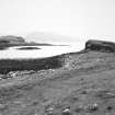
NG 2776 0410. A stack, the only access to which, in the N, has been blocked at the head of a slope by a wall c. 1.6m thick which is visible for c. 8.0m in fragmentary condition. Against the inner face are traces of a subcircular structure c. 3m in internal diameter. There is not enoough evidence to classify this as a prehistoric structure.
Visited by OS 29 May 1972.
(Location amended to NG 2776 0409 and classification to enclosure and possible hut). A terrace on the NW side of a stack overlooking the W shore of Suileabhaig is enclosed by two stretches of stone wall. The walls lie at the NNE and SSW ends of the terrace, and, although now grass-grown, they measure up to 1.4m in thickness and 0.6m in height. A crescent-shaped structure, possibly a hut, abuts the inner edge of the NNE wall; this measures 4.4m from NNW to SSE by 3.4m transversely within a grass-grown stony bank 1m in thickness and 0.3m in height.
(Canna 99-100).
Visited by RCAHMS (ARG, IMS), 2 May 1994.
Field Visit (29 May 1972)
NG 2776 0410. A stack, the only access to which, in the N, has been blocked at the head of a slope by a wall c. 1.6m thick which is visible for c. 8.0m in fragmentary condition. Against the inner face are traces of a subcircular structure c. 3m in internal diameter. There is not enoough evidence to classify this as a prehistoric structure.
Visited by OS 29 May 1972.
Field Visit (2 May 1994)
(Location amended to NG 2776 0409 and classification to enclosure and possible hut). A terrace on the NW side of a stack overlooking the W shore of Suileabhaig is enclosed by two stretches of stone wall. The walls lie at the NNE and SSW ends of the terrace, and, although now grass-grown, they measure up to 1.4m in thickness and 0.6m in height. A crescent-shaped structure, possibly a hut, abuts the inner edge of the NNE wall; this measures 4.4m from NNW to SSE by 3.4m transversely within a grass-grown stony bank 1m in thickness and 0.3m in height.
(Canna 99-100).
Visited by RCAHMS (ARG, IMS), 2 May 1994.

