|
Photographs and Off-line Digital Images |
C 45286 |
|
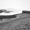
Sanday, Sean Dun and Suileabhaig. View of fort, enclosure and possible hut from NW. |
6/1994 |
Item Level |
|
|
Prints and Drawings |
DC 46235 |
|
Miscellaneous NMRS sites and monuments on map sheet NG20SE: large-scale annotated dyeline plan.
(Areas and direction of rig indicated in pencil).
|
c. 1996 |
Item Level |
|
|
Digital Files (Non-image) |
DX 001432 |
Records of the Royal Commission on the Ancient and Historical Monuments of Scotland (RCAHMS), Edinbu |
RCAHMS Structures Database - Canna |
1994 |
Item Level |
|
|
Digital Files (Non-image) |
TM 000323 |
Records of the Royal Commission on the Ancient and Historical Monuments of Scotland (RCAHMS), Edinbu |
Zip file containing the final survey linework dxf file for the RCAHMS National Archaeological Survey of Canna 1994, OS Antiquity model dxf files and a document detailing the files and the survey methodology. |
1996 |
Item Level |
|
 |
On-line Digital Images |
SC 2245853 |
|
Sanday, Sean Dun and Suileabhaig. View of fort, enclosure and possible hut from NW. |
6/1994 |
Item Level |
|
 |
On-line Digital Images |
SC 2358273 |
Records of the Ordnance Survey, Southampton, Hampshire, England |
Sanday, Suileabhaig, NG20SE 16, Ordnance Survey index card, Recto |
1958 |
Item Level |
|
|
Digital Files (Non-image) |
TM 002344 |
Records of the Royal Commission on the Ancient and Historical Monuments of Scotland (RCAHMS), Edinbu |
Zip file containing the final survey linework for the RCAHMS National Archaeological Survey of Canna 1994. Shapefile and Geojson format. |
1996 |
Item Level |
|
|
All Other |
551 166/1/1 |
Records of the Ordnance Survey, Southampton, Hampshire, England |
Archaeological site card index ('495' cards) |
1947 |
Sub-Group Level |
|


