
Pricing Change
New pricing for orders of material from this site will come into place shortly. Charges for supply of digital images, digitisation on demand, prints and licensing will be altered.
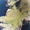
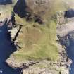
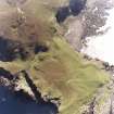
Canna, Rubha Langanes


Structure(S) (Period Unassigned)
Site Name Canna, Rubha Langanes
Classification Structure(S) (Period Unassigned)
Alternative Name(s) Rudha Langanes; Rudha Langaninnis; Tarbert; 'king Of Norway's Grave'
Canmore ID 10733
Site Number NG20NW 3
NGR NG 2410 0657
NGR Description NG 2410 0657, NG 2413 0656 and NG 2414 0667
Datum OSGB36 - NGR
Permalink http://canmore.org.uk/site/10733


- Council Highland
- Parish Small Isles
- Former Region Highland
- Former District Lochaber
- Former County Inverness-shire
NG20NW 3 2410 0657, 2413 0656 and 2414 0667
See also NG20SE 2, NG20SE 3, NG20SE 4, NG20SE 9.
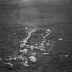
(NG 2411 0659). (Information from private 6" map of T C Lethbridge 1953). A kerb of stones is all that remains of a burial cairn of the Viking period on a strip of machair below the cliffs at Rudha Langaninnis. The kerb, of smallish stones set fairly close together, encloses an area 32ft NW-SE by 6 1/2ft NE-SW. Two similar burials have been found in Arran and Colonsay, dated by coin finds to the 9th century AD.
Information from OS c.1972
RCAHMS 1928.
Field Visit (4 July 1925 - 6 July 1925)
Viking Burials.
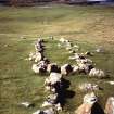
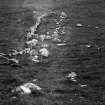
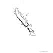
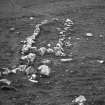
On the strip of machair below the cliffs at Rudha Langaninnis is a setting of stones (Fig. 310), which has formed the kerb of a burial cairn of a type hitherto unnoted in these Inventories. One similar occurs in Arran, where excavation exposed, amongst other relics, incinerated bones and boat rivets and a coin of the 9th century, a styca of Wigmund (A.D. 831-854), Archbishop of York. Another burial of this kind was located in Colonsay, and yielded, on being explored, skeletal remains both human and of a horse, boat rivets and clinker nails, weapons and three stycas, the latest issued by Wigmund (1). The Langaninnis burial has been despoiled and the kerb only remains, enclosing an area 32 feet from north-west to south-east by 6½ feet from north-east to south-west. The end nearest the sea is slightly rounded, the other end is fairly rectangular, and there may be a small outer chamber beyond it, as in the Arran burial. The kerb is formed of detritus, smallish stones about 18 inches in diameter and height above ground, set fairly close together.
Three other burials of similar type were noted in the adjoining island of Sanday. The first,200 yards east of Ant-Oban, measures 41 feet by 4 feet within the kerb; the second, lying beneath the north-west base of the knoll Sean Dun and overlooking Ant-Oban, measures 17 feet by 4½ feet; and the third, lying about 100 yards east of the stack Dun Beag, measures 17 feet by 4 feet 4 inches. These graves are unorientated, and their setting is determined by the lie of the ground.
(1) Proc. Soc. Ant. Scot., XLI., 443
RCAHMS 1928, visited 4 and 6 July 1925.
OS map: Island of Canna liii and liv ; and Islands of Rum, Sanday, etc. (Inverness-shire), lx (unnoted).
Field Visit (1 June 1972)
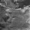
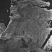
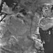
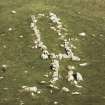
These 'structures' are all marked by two parallel lines of contiguous stones on edge, some slightly curved, generally 1.0m to 1.5m apart, and varying in length between 3.5m and 26.0m. They have no common orientation. The ends of some are formed by a single boulder, and others by two or three stones on edge. None has any trace of a covering mound, although most protrude through a heavy turf or peat cover. A few have a more recent appearance, but these all occur on the shore where they are in close-cropped turf. They occur both on level ground and on slopes. It is probable that some near the shore-line are kelp kilns, but no certain identification of any of the structures is possible. They do not seem to mark burial places.
Visited by OS (A A) 1 June 1972.
Field Visit (27 May 1972)
A rectangular setting of stones on sloping ground at NG 2407 0658 and generally as described by the RCAHMS. About 20.0m to the NNE, on the flat, is a similar but smaller structure oriented in the same direction and measuring 3.5m by 1.4m transversely. About 110.0m NNE is a third, facing down the slope, measuring 7.7m NNW- SSE by 2.6m at the S end (which appears to be curved) and contracting to 1.9m at the N end which is square.
Visited by OS (I S S) 27 May 1972.
Field Visit (5 May 1994)
(Previously classified as 'Viking burials' and buildings; name cited as Rudha Langaninnis at NG 2407 0658. Reclassified as Structures, name amended to Rubha Langanes and re-located at NG 2410 0657, 2413 0656 and 2414 0667). Three narrow rectangular structures lie on a low grass-grown promontory below the cliffs at Rubha Langanes.
NG 2410 0657. The largest structure lies at the foot of the N-facing escarpment marking the S end of the promontory, and has been set end-on into the slope. Its sides and ends are defined by rows of boulders set on edge, although some forming the W side appear to have been displaced. It measures 9.8m from NNW to SSE by 1.3m internally, but a series of boulders at its S end, some of which have been set on edge, extend a further 5.3m up the slope. About 20m to the NNE, there is another subrectangular structure, defined by little more than an irregular line of boulders and measuring at least 2.4m from NNW to SSE by 0.9m internally. Some of the stones have been removed and placed in an arc immediately to the S, probably at a relatively recent date.
NG 2413 0656. Overlooking these structures from a terrace above, there are the remains of what may be a small hut, now reduced to little more than an oval mound from which six boulders protrude.
NG 2414 0667. The third of the rectangular structures is situated about 100m to the NNE, towards the edge of the cliff, and measures 7.3m from NNW to SSE by 1.6m internally; it too has been damaged and the lines of boulders defining its sides are irregular and displaced.
(Canna 187-91)
Visited by RCAHMS (IMS, ARG), 5 May 1994
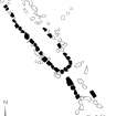
Measured Survey (13 March 1996)
RCAHMS surveyed the stone structure at Rubha Langanes, Canna on 13 March 1996 with plane-table and alidade at a scale of 1:100. The plan was redrawn in ink and later used as the basis for an illustration which was published in 2016 (Hunter, fig. 2.30).

