|
Prints and Drawings |
RCD 31/2 |
|
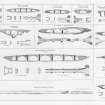
"Elevation, plan and dimensions of bridges in the Highlands of Scotland, made and constructed under the direction of the Commissioners for Highland roads and bridges 1803-1821"
Thomas Telford, engineer; Engraved by Edmund Turrell; Drawn by R H Palmer
Covers the following bridges: Bridge at Greystones, Latheran Wheel Bridge, Balnagown Bridge, Allness Bridge, Easter Fearn, Bridge over the Varrar, Cannech Bridge, Bridge over the Diak, Bridge for the Aultmore, Sheal Bridge, Cros Bridge, Bridge over the river Moriston, Borlam Bridge, Bridge of Ballachandraine, Adrie Bridge, Calder Bridge, Kirk Laggan Bridge, Bridge for the Water of Roy, Spean Bridge, Bonar Bridge over the Dornoch Firth, Contin Bridge, Craig Ellachie, Alford Bridge over the river Don, Wick Bridge, Helmsdale Bridge, Aultnaharrar Bridge over the Tarrie, Conan Bridge, Dunkeld Bridge over the river Tay, Lovat Bridge, Potarch Bridge over river Dee, Torgoyle Bridge, Balater Bridge over river Dee, Strathfleet Mound and Bridge, Fairness Bridge, Bridge and river Nethy.
|
1821 |
Item Level |
|
|
Photographs and Off-line Digital Images |
IN 2000 |
G Ronald Curtis |
View of upstream side of bridge |
1965 |
Item Level |
|
|
Photographs and Off-line Digital Images |
IN 1993 |
G Ronald Curtis |
View of upstream side of bridge |
1965 |
Item Level |
|
|
Photographs and Off-line Digital Images |
IN 1994 |
G Ronald Curtis |
View of upstream side of bridge |
1965 |
Item Level |
|
|
Photographs and Off-line Digital Images |
IN 2004 |
G Ronald Curtis |
View of upstream side of bridge from south |
1965 |
Item Level |
|
|
Photographs and Off-line Digital Images |
IN 2005 |
G Ronald Curtis |
View of upstream side of bridge |
1965 |
Item Level |
|
|
Photographs and Off-line Digital Images |
IN 2009 |
G Ronald Curtis |
Detail of bench mark in abutment |
1965 |
Item Level |
|
|
Photographs and Off-line Digital Images |
IN 2010 |
G Ronald Curtis |
View of upstream side of bridge from south |
1965 |
Item Level |
|
|
Photographs and Off-line Digital Images |
IN 2013 |
G Ronald Curtis |
View of downstream side of bridge from north |
1965 |
Item Level |
|
|
Photographs and Off-line Digital Images |
IN 2014 |
G Ronald Curtis |
View over bridge from south |
1967 |
Item Level |
|
|
Photographs and Off-line Digital Images |
IN 2015 |
G Ronald Curtis |
View over side of bridge |
1967 |
Item Level |
|
 |
On-line Digital Images |
DP 018082 |
General Collection |
Engraving of elevation and plan inscr: ''Elevation, Plan and Dimensions of Bridges in the Highlands of Scotland, made and constructed under the direction of The Commissioners for Highland Roads and Bridges 1803-1821.'' |
1838 |
Item Level |
|
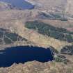 |
On-line Digital Images |
DP 111916 |
RCAHMS Aerial Photography Digital |
General oblique aerial view of the remains of the Fort Augustus-Bernera Military Road and the dams of Loch Cluanie and Loch Loyne, taken from the SSE. |
1/5/2011 |
Item Level |
|
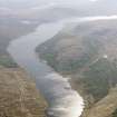 |
On-line Digital Images |
DP 111917 |
RCAHMS Aerial Photography Digital |
General oblique aerial view of Loch Loyne dam and reservoir, taken from the NE. |
1/5/2011 |
Item Level |
|


