
Following the launch of trove.scot in February 2025 we are now planning the retiral of some of our webservices. Canmore will be switched off on 24th June 2025. Information about the closure can be found on the HES website: Retiral of HES web services | Historic Environment Scotland
Loch Loyne Bridge


Road Bridge (Period Unassigned)
Site Name Loch Loyne Bridge
Classification Road Bridge (Period Unassigned)
Alternative Name(s) Drochaid Nam Paiteachain; North Bridge
Canmore ID 106621
Site Number NH20NW 2
NGR NH 15365 04769
Datum OSGB36 - NGR
Permalink http://canmore.org.uk/site/106621


- Council Highland
- Parish Urquhart And Glenmoriston
- Former Region Highland
- Former District Inverness
- Former County Inverness-shire
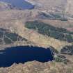
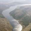
Exact location unknown, however it may have been flooded by the dam at the east end of Loch Loyne.
Note (2 April 2013)
This bridge formerly carried Telford’s road from Tomdoun to Cluaine over the northern channel of Loch Loyne at na Paiteachain. A second, smaller bridge is recorded separately to the S at NH 15338 04569. (NH20NW 1). The route and bridges were abandoned when the waters of the loch were raised as part of a hydroelectric scheme.The course of the road and the two bridges over Loch Loyne are depicted on the 1st Edition of the OS 6-inch map (Inverness-shire 1883 sheet lxxxi).
Information from RCAHMS (PMcK) 2 April 2013.

