
Langbank, Bogside


Anti Aircraft Battery (20th Century)
Site Name Langbank, Bogside
Classification Anti Aircraft Battery (20th Century)
Alternative Name(s) Gsg9; S9; Clyde Aa Defences; Gallahill Wood Battery; Steel Cottage; Gleddoch House Hotel
Canmore ID 106360
Site Number NS37SE 30
NGR NS 37643 72024
NGR Description Centred NS 37643 72024
Datum OSGB36 - NGR
Permalink http://canmore.org.uk/site/106360


- Council Renfrewshire
- Parish Erskine
- Former Region Strathclyde
- Former District Renfrew
- Former County Renfrewshire
NS37SE 30 centred 37643 72024
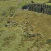
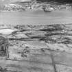
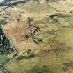
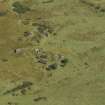
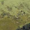
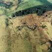
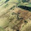
This anti-aircraft battery is situated to the S of Langbank, some 100m SE of two radio masts on the top of Gallahill.
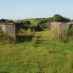
It consists of four gun emplacements and two separate magazine buildings, the command post is extant, but has been buried. The battery is in fair condition.
Information from Mr J Guy, August 1996
This World War II heavy anti-aircraft battery is situated SE of Bogside Farm on northeast-facing sloping ground near two masts. The four brick and concrete gun-emplacements and two magazine buildings survive. The battery was armed with 4 3.7-inch guns.
J Guy 2001; NMRS MS 810/11, Part 2, 162-3, Vol.2 (appendix), 16.
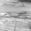
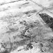
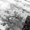
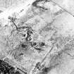
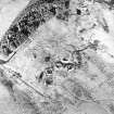
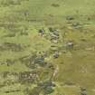
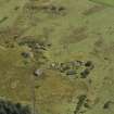
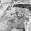
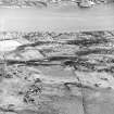
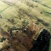
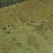
This heavy anti-aircraft battery is visible on RAF post-war vertical air photographs (106G/UK 1208, 5388-9, flown 7 March 1946. The gun positions are as described by Guy (J Guy 2001), but the accommodation camp is visible to the W of the battery and immediately to the E of the minor road from Bogside to North Glen farmsteadings. No evidence of a radar installation (GL-mat and ramp) can be seen on the photograph
Information from RCAHMS (DE), November 2002.
Oblique aerial photographs taken in September 2007 (RCAHMS 2007), show that one gun emplacement (NS 37634 72047) has had the concrete ready use lockers removed from within the encircling concrete outer wall. The other structures on the site would appear to be as described above.
Information from RCAHMS (DE), December 2007.
Scheduled as 'Steel Cottage, anti-aircraft battery 480m NW of... the remains of a heavy anti-aircraft battery, dating to the Second World War. Consisting of a command post, several gun emplacements and a number of associated buildings, the site is located on a SE facing slope some 480m north-west of Steel Cottage. The battery lies in an area of rough grazing on the slopes of Gallahill, adjacent to a golf course [NS37SE 77] attached to the Gleddoch House Hotel [NS37SE 48]. [It] consists of four upstanding gun emplacements, two ammunition magazines, an outbuilding and the earthwork remains of a setting for three fuel tanks.'
Information from Historic Scotland, scheduling document dated 25 March 2011.
Field Visit (2 August 2017)
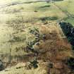
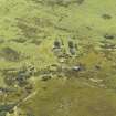
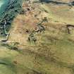
This heavy anti-aircraft battery is situated just below the crest of a ridge in broken, marshy ground, about 200m E of a minor public road leading S from the Old Greenock Road. It comprises four gun emplacements, a command post, two magazines, a gun store and a storage tank. It was one of at least 43 such batteries that were constructed to protect the industries in the centre of Glasgow and along the banks of the River Clyde from aerial attack by the Luftwaffe during WWII
The battery is approached initially from the public road via a tarmacadam track that leads ESE for 70m before bifurcating. While this continues NE along the ESE side of a coniferous plantation towards the farm at Undercraig, a grass-grown branch heads SE for 140m, before turning sharply NNE to run between the gun emplacements and the command post. Originally, short spurs extended N and W to reach the two magazines behind the gun-pits, but that on the S has been subsequently blocked with an earth bank. All the gun-pits are planned around the circumference of a circle with radius of 35m pivoted on a NE to SW axis.
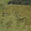
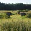
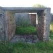
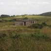
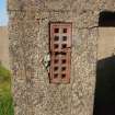
The four gun-pits (NS 37660 72047, NS 37633 72046, NS 37615 72027, NS 37617 71999) can be separated into two pairs, one on the N arc of the circle and one on the W. All are of the same design and each is protected by an earthen bund. They are octagonal on plan and measure 13m in diameter within reinforced cast concrete blast walls 0.3m thick and 1.7m high. Opposed double gateways 3.5m wide occupy two sides, but in all except the NE gun-pit, the N or W entrances have been blocked-up. In each gun-pit, six open-ended ammunition lockers are symmetrically arranged against the inner side of the blast wall, although those in the NE gun--pit have all been demolished. Each has a flat reinforced cast concrete roof, a raised concrete floor, brick linings, two rows of putlogs supporting three wooden racks for shells and open ends parallel with the blast wall. Whereas the lockers adjacent to the gateways measure 2m long, 1.5m wide and 1.5m high, within an inner wall 0.15m thick, the volume of space within the central lockers is very slightly smaller as their inner walls measuring 0.35m thick, accommodate a pair of vertical airbricks at each end near their top and bottom. The concrete hardstanding in the N gun-pit is partly visible, but the others are all heavily grass-grown. Three of the gun-pits are provided with a reinforced cast concrete shelter attached to their external wall face and incorporated in the bund. They are rectangular on plan, measuring 5.4m by 3.5m transversely, over reinforced cast concrete walls 0.35m thick, with flat roofs and an off-centred doorway facing the command post.
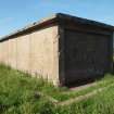
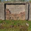
What remains of the brick-built command post (NS 37642 72020) is situated about 20m ESE of the gun-pits. It has been deliberately buried in an earthen mound and very little apart from a bitumen covered flat roof is now visible.
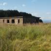
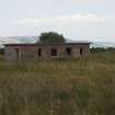
By contrast, the two matching magazines (NS 37647 72066, NS 37596 72012) - each supporting a pair of gun-pits - are well-preserved, although the front and sides of that on the N have also been buried, leaving only its rear wall and flat concrete roof visible. Unlike its counterpart to the SW, it has been cut back into the rising ground necessitating the construction of a deep, concrete-revetted gully to its rear. Each is rectangular on plan, measuring 11.75m by 4.2 transversely, within reinforced cast concrete walls 0.15 thick and 2.85m high. Their overhanging flat roofs have been waterproofed with bitumen, while their facades are buttressed with six plain rectangular pilasters spaced at regular intervals. Three entrances, measuring 1.22m wide and 2m high, and two small rectangular windows with cast concrete sills, alternate between each pair of buttress. The double doors are all missing, but a wooden frame survives within the S window of the W magazine. The rear corners of the buildings are also buttressed, but the walls are otherwise plain. Their interiors are divided into five compartments linked by a corridor running the length of the building. The central bay and those at each end have circular, metal-lined vents in the roof. Symmetrical curved concrete paths, bordered in part by dwarf walls, originally linked each magazine to its gun pits, entering by their N or W gateways, respectively; but (as has been indicated) only that approaching the E gun-pit of the more northerly pair remains open.
The gun store (NS 37602 72057) is situated in especially wet ground midway between the magazines and about 17m NW of the battery to which it is linked by a very narrow earthen causeway running SE. It is rectangular on plan and measures 8.2m from ESE to WNW by 6.7m transversely within reinforced cast concrete walls 0.3m thick and 2.45m high. There is a shallow outshot on the NW which shares the same flat reinforced concrete roof waterproofed with bitumen. There is a wide entrance to the N in the SE wall of the building, while the SW facade features four widows with cast concrete lintels and sills – two narrow and rectangular positioned either side of two that are broad and square. The interior has a concrete floor and the roof has been strengthened with three transverse concrete beams. Although there are two circular vents in the roof, it has otherwise been stripped of its fittings.
No remains of the camp or a radar array were observed, but there is a concrete tank (NS 37504 72114) in the shelter belt about 150m NW of the battery. This measures 4.9m square and rises at least 1.25m above the surrounding earthen bund. There is a hatch close to its SW edge providing access to four iron rungs which lead down to water at least 1.5m deep.
Visited by HES, Survey and Recording (ATW, ARG) 2 August 2017.

