
Pricing Change
New pricing for orders of material from this site will come into place shortly. Charges for supply of digital images, digitisation on demand, prints and licensing will be altered.
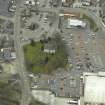
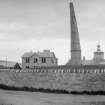
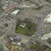
Dingwall, Tulloch Street, Obelisk To Earl Of Cromarty


Commemorative Monument (18th Century), Obelisk (20th Century), Ting (Viking)(Possible)
Site Name Dingwall, Tulloch Street, Obelisk To Earl Of Cromarty
Classification Commemorative Monument (18th Century), Obelisk (20th Century), Ting (Viking)(Possible)
Alternative Name(s) Dingwall, Tulloch Street, Cromartie Obelisk; Tulloch Street, Leaning Tower
Canmore ID 106303
Site Number NH55NW 154
NGR NH 54981 58916
Datum OSGB36 - NGR
Permalink http://canmore.org.uk/site/106303


- Council Highland
- Parish Dingwall
- Former Region Highland
- Former District Ross And Cromarty
- Former County Ross And Cromarty
NH55NW 154 54981 58916
Monument [NAT]
OS (GIS) MasterMap, April 2010.
Original tower taken down in 1920 and replica built on site in 1921.
(Undated) information in NMRS.
Ground Penetrating Radar (11 September 2011 - 12 September 2011)
NH 54981 58916 A ground penetrating radar survey was undertaken, 11–12 September 2011, in the car park on the N side of Dingwall town centre. The survey was carried out as part of a research and community project, which is investigating the archaeology of Dingwall’s Viking assembly site or ‘thing’.
Prior to 1947 the site was the location of a large earth mound, known from at least the 16th century as the Moothill (‘hill of assembly’), and subsequently adapted as a burial memorial for the First Earl of Cromartie in 1714. The survey aimed to locate remains of the mound and assess the area for any other significant deposits. A possible ditch, c5m wide and 2m deep was identified on the N, W and S side of the mound’s historic footprint. Truncation of the site from modern services and post-medieval buildings were indicated across the S side of the car park. Anomalies that probably relate to Victorian trenching at the mound in 1875 were also noted around the centre and S side of the site. Foundations of an enclosure wall built in 1819 and known as the Hillyard were also traced.
Archive: Highland Council (deposited) and RCAHMS (intended)
Funder: Dingwall History Society, Society of Antiquaries of Scotland, Hunter Archaeological Trust, Strathmartine Trust and Highland Council
OJT Surveys, 2011
Excavation (11 September 2012 - 17 September 2012)
NH 54981 58916 A trial excavation was undertaken 11–17 September 2012 in the car park on the N side of Dingwall town centre. The work was carried out as part of a collaborative community dissemination event supported by Highland Council. This contributed to the Thing Project Northern Periphery Programme and Dingwall Thing Project.
Prior to 1947 the site was the location of a large earth mound, known from at least the 16th century as the Moothill (‘hill of assembly’), and subsequently adapted as a burial memorial for the First Earl of Cromartie in 1714. The excavation aimed to test the veracity of a radar survey undertaken in 2011 (DES 2011, 103). Cathy MacIver and RoCAS were also commissioned to undertake a topographic survey and GPS recording of the excavation.
A 20 x 2m trench was dug across the N side of the car park, extending from a centrally located memorial wall to the car park boundary. A possible ditch was identified as an estuary inlet which contained successive layers of mud and sand >2m deep. This suggested that the mound was originally located on a small natural promontory or island. The mound had been truncated by levelling for the car park in the 20th century. Exposure of the mound’s core showed it to be composed of natural clays cut by the wall of an adjacent memorial garden. At the N edge of the mound a series of truncated silt and clay layers confirmed that the monument was partially man-made. These deposits were cut by the foundations of a mortared sandstone wall. The wall was the remains of a rectangular enclosure and probably part of a mausoleum constructed on the mound in 1714. Medieval pottery and iron objects were recovered from the outer slope of the mound’s edge. A flint core and fragment of wood were recovered from the lower deposits of the estuarine mud. Several charcoal deposits were taken for radiocarbon dating of the mound, as were bulk soil and micromorphology samples. Volunteers participated in the excavation and guided tours were provided for local school pupils.
Archive: Highland Council and RCAHMS (intended)
Funder: Dingwall History Society, Society of Antiquaries of Scotland, Hunter Archaeological Trust, Strathmartine Trust, The Highland Council and Thing Project
Oliver JT O’Grady, OJT Heritage, 2012
(Source: DES)

