
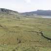
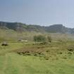
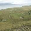
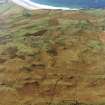
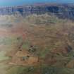
Eigg, Cleadale


Croft(S) (19th Century), Cultivation Remains (Period Unassigned), Field System (Period Unassigned), Township (Post Medieval)
Site Name Eigg, Cleadale
Classification Croft(S) (19th Century), Cultivation Remains (Period Unassigned), Field System (Period Unassigned), Township (Post Medieval)
Alternative Name(s) Isle Of Eigg, Cleadale Township
Canmore ID 106157
Site Number NM48NE 31
NGR NM 477 888
NGR Description Centred on NM 477 888
Datum OSGB36 - NGR
Permalink http://canmore.org.uk/site/106157
Ordnance Survey licence number AC0000807262. All rights reserved.
Canmore Disclaimer.
© Bluesky International Limited 2025. Public Sector Viewing Terms
- Correction
- Favourite

SC 1398954
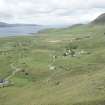
Elevated view from SSE
Records of the Royal Commission on the Ancient and Historical Monuments of Scotland (RCAHMS), Edinbu
5/8/1999
© Crown Copyright: HES

SC 1398955
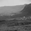
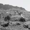
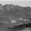
Elevated view of Cleadale township
Records of the Royal Commission on the Ancient and Historical Monuments of Scotland (RCAHMS), Edinbu
5/8/1999
© Crown Copyright: HES

SC 1398963
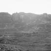
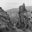
General view towards Howlin from WNW
Records of the Royal Commission on the Ancient and Historical Monuments of Scotland (RCAHMS), Edinbu
5/8/1999
© Crown Copyright: HES

SC 1399210
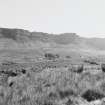
General view from NE
Records of the Royal Commission on the Ancient and Historical Monuments of Scotland (RCAHMS), Edinbu
5/8/1999
© Crown Copyright: HES

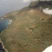
SC 1865033
Oblique aerial view of Cleadale, Isle of Eigg, looking N.
Papers of James Sloan Bone, landscape historian, Inverness, Highland, Scotland
1994
© Copyright: NOSAS (James S Bone Collection). Courtesy of HES.

SC 2563793
Elevated view from SE
Records of the Royal Commission on the Ancient and Historical Monuments of Scotland (RCAHMS), Edinbu
5/8/1999
© Crown Copyright: HES

SC 2563797
Elevated view from SSE
Records of the Royal Commission on the Ancient and Historical Monuments of Scotland (RCAHMS), Edinbu
5/8/1999
© Crown Copyright: HES

SC 2563799
Elevated view of Cleadale township
Records of the Royal Commission on the Ancient and Historical Monuments of Scotland (RCAHMS), Edinbu
5/8/1999
© Crown Copyright: HES

SC 2563801
Elevated view from SE
Records of the Royal Commission on the Ancient and Historical Monuments of Scotland (RCAHMS), Edinbu
5/8/1999
© Crown Copyright: HES

SC 2563805
View of township from NNE
Records of the Royal Commission on the Ancient and Historical Monuments of Scotland (RCAHMS), Edinbu
5/8/1999
© Crown Copyright: HES

SC 2563820
View towards Howlin from WNW
Records of the Royal Commission on the Ancient and Historical Monuments of Scotland (RCAHMS), Edinbu
5/8/1999
© Crown Copyright: HES

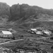
SC 743149
General view of Cleadale houses, Eigg
Papers of Erskine Beveridge, antiquarian, Dunfermline, Fife, Scotland
25/9/1883
© Courtesy of HES (Erskine Beveridge Collection)

SC 875772
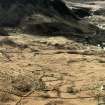
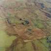
Oblique aerial view of the crofting township and field-system with farmstead adjacent taken from the WSW.
RCAHMS Aerial Photography
10/4/2003
© Crown Copyright: HES

SC 1398960
General view from NE
Records of the Royal Commission on the Ancient and Historical Monuments of Scotland (RCAHMS), Edinbu
5/8/1999
© Crown Copyright: HES

SC 1551749
Eigg, Cleadale and Howlin, townships. General view of Cleadale and Howlin from E.
Records of the Royal Commission on the Ancient and Historical Monuments of Scotland (RCAHMS), Edinbu
2001
© Crown Copyright: HES

SC 1551751
Eigg, Cleadale. General view of Cleadale from S.
Records of the Royal Commission on the Ancient and Historical Monuments of Scotland (RCAHMS), Edinbu
4/2002
© Crown Copyright: HES

SC 1551810
Eigg, Cleadale and Howlin, Field Systems and Croft Boundaries. General view of Townships
Records of the Royal Commission on the Ancient and Historical Monuments of Scotland (RCAHMS), Edinbu
2002
© Crown Copyright: HES

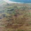
SC 1699306
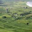
Oblique aerial view of the crofting township and field-system, taken from the ENE.
RCAHMS Aerial Photography
10/4/2003
© Crown Copyright: HES

SC 1699308
Oblique aerial view of the crofting township and field-system with farmstead adjacent taken from the NE.
RCAHMS Aerial Photography
10/4/2003
© Crown Copyright: HES

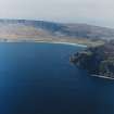
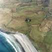
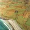
SC 1699315
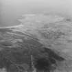
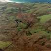
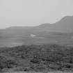
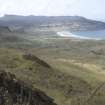
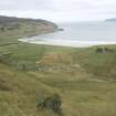
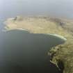
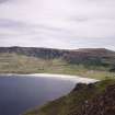
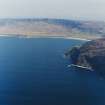
General oblique aerial view centred on the Bay of Laig with the crofting township beyond and the remains of the fort adjacent, taken from the W.
RCAHMS Aerial Photography
10/4/2003
© Crown Copyright: HES

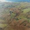
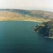
SC 1699342
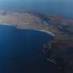
General oblique aerial view of Cleadale and the north end of Eigg, taken from the S.
RCAHMS Aerial Photography
10/4/2003
© Crown Copyright: HES

SC 1699491
General oblique aerial view looking across Laig Bay, with the fort in the foreground, towards Cleadale and the north side of Eigg, taken from the W.
RCAHMS Aerial Photography
10/4/2003
© Crown Copyright: HES

SC 2563803
View of specimen croft from NW
Records of the Royal Commission on the Ancient and Historical Monuments of Scotland (RCAHMS), Edinbu
5/8/1999
© Crown Copyright: HES

SC 2563808
View of township from NNE
Records of the Royal Commission on the Ancient and Historical Monuments of Scotland (RCAHMS), Edinbu
5/8/1999
© Crown Copyright: HES

SC 2563810
General view from NE
Records of the Royal Commission on the Ancient and Historical Monuments of Scotland (RCAHMS), Edinbu
5/8/1999
© Crown Copyright: HES

SC 2563815
General view from ESE
Records of the Royal Commission on the Ancient and Historical Monuments of Scotland (RCAHMS), Edinbu
5/8/1999
© Crown Copyright: HES

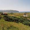
SC 743161
Eigg, Cleadale General view of farms, and looking towards Laig Bay
Papers of Erskine Beveridge, antiquarian, Dunfermline, Fife, Scotland
c. 1890
© Courtesy of HES (Erskine Beveridge Collection)

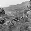
SC 771499
Eigg, Cleadale, Township. View of croft boundaries at N end of Cleadale township from W.
Records of the Royal Commission on the Ancient and Historical Monuments of Scotland (RCAHMS), Edinbu
2001
© Crown Copyright: HES

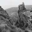
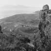
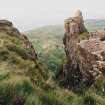
SC 771503
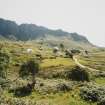
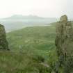
View of croft boundaries and earlier field-system from cliffs to N of Cleadale, Eigg.
Records of the Royal Commission on the Ancient and Historical Monuments of Scotland (RCAHMS), Edinbu
5/2001
© Crown Copyright: HES

SC 883555
Oblique aerial view of the crofting township and field-system with farmstead adjacent taken from the NE.
RCAHMS Aerial Photography
10/4/2003
© Crown Copyright: HES

SC 1113039
General view of Cleadale houses
Papers of Erskine Beveridge, antiquarian, Dunfermline, Fife, Scotland
25/9/1883
© Courtesy of HES (Erskine Beveridge Collection)

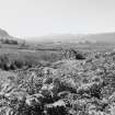
SC 1113300
General view of Cleadale in the distance, with A'Chuagach in the foreground
1913
© RCAHMS


DP 050866
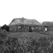
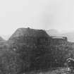
View of the only inhabited thatched house on Eigg
Photographs by Violet Banks, professional photographer, Edinburgh, Scotland
1920
© Courtesy of HES (Violet Banks Collection)

SC 1551744
Eigg, Cleadale. General view from S.
Records of the Royal Commission on the Ancient and Historical Monuments of Scotland (RCAHMS), Edinbu
2001
© Crown Copyright: HES

SC 1551823
Eigg, Cleadale, Township and Field system. General view from NE.
Records of the Royal Commission on the Ancient and Historical Monuments of Scotland (RCAHMS), Edinbu
2001
© Crown Copyright: HES

SC 1574449
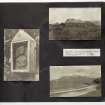
Copy of a historic photographic view of Cleadale township from the Banff Album.
General Collection. Photograph Albums.
7/1913

SC 1676214
Oblique aerial view centred on the church, crofting township and field-system, taken from the SW.
RCAHMS Aerial Photography
10/4/2003
© Crown Copyright: HES

DP 302499
General view SW over Cleadale towards Laig bay.
Papers of Dr George F Geddes, archaeologist, Edinburgh, Scotland
12/7/2019
© Copyright: G F Geddes. Courtesy of HES.

SC 2563794
Elevated view from SE
Records of the Royal Commission on the Ancient and Historical Monuments of Scotland (RCAHMS), Edinbu
5/8/1999
© Crown Copyright: HES

SC 2563795
Elevated view from SE
Records of the Royal Commission on the Ancient and Historical Monuments of Scotland (RCAHMS), Edinbu
5/8/1999
© Crown Copyright: HES

SC 2563807
View of township from NNE
Records of the Royal Commission on the Ancient and Historical Monuments of Scotland (RCAHMS), Edinbu
5/8/1999
© Crown Copyright: HES

SC 2563817
General view towards Howlin from WNW
Records of the Royal Commission on the Ancient and Historical Monuments of Scotland (RCAHMS), Edinbu
5/8/1999
© Crown Copyright: HES


SC 1398953
Elevated view from SE
Records of the Royal Commission on the Ancient and Historical Monuments of Scotland (RCAHMS), Edinbu
5/8/1999
© Crown Copyright: HES

SC 1398957
Distant view from S
Records of the Royal Commission on the Ancient and Historical Monuments of Scotland (RCAHMS), Edinbu
5/8/1999
© Crown Copyright: HES

SC 1398961
General view from NNE
Records of the Royal Commission on the Ancient and Historical Monuments of Scotland (RCAHMS), Edinbu
5/8/1999
© Crown Copyright: HES

SC 1399209
View of specimen croft from NW
Records of the Royal Commission on the Ancient and Historical Monuments of Scotland (RCAHMS), Edinbu
5/8/1999
© Crown Copyright: HES

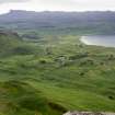
SC 1551754
Eigg, Cleadale. General view of Cleadale to Laig from NE.
Records of the Royal Commission on the Ancient and Historical Monuments of Scotland (RCAHMS), Edinbu
2002
© Crown Copyright: HES

SC 1699314
Oblique aerial view of the crofting township and field-system, taken from the WNW.
RCAHMS Aerial Photography
10/4/2003
© Crown Copyright: HES

DP 390948
Violet Banks Photograph Album - The Small Isles - Page 9 - Eigg; St. Donan's Chapel; The "Singing Sands"
Photographs by Violet Banks, professional photographer, Edinburgh, Scotland
c. 1920
© Courtesy of HES (Violet Banks Collection)

SC 2563741
Copy of a historic photographic view of Cleadale township, from the Banff Album.
General Collection. Photograph Albums.
7/1913
© RCAHMS

SC 2563796
Elevated view from SE
Records of the Royal Commission on the Ancient and Historical Monuments of Scotland (RCAHMS), Edinbu
5/8/1999
© Crown Copyright: HES

SC 2563802
Distant view from S
Records of the Royal Commission on the Ancient and Historical Monuments of Scotland (RCAHMS), Edinbu
5/8/1999
© Crown Copyright: HES

SC 2563809
General view from NE
Records of the Royal Commission on the Ancient and Historical Monuments of Scotland (RCAHMS), Edinbu
5/8/1999
© Crown Copyright: HES

SC 2563816
General view from ESE
Records of the Royal Commission on the Ancient and Historical Monuments of Scotland (RCAHMS), Edinbu
5/8/1999
© Crown Copyright: HES

SC 875777
Oblique aerial view of the crofting township and field-system, taken from the ENE.
RCAHMS Aerial Photography
10/4/2003
© Crown Copyright: HES

SC 1398956
Elevated view from SE
Records of the Royal Commission on the Ancient and Historical Monuments of Scotland (RCAHMS), Edinbu
5/8/1999
© Crown Copyright: HES

SC 1398959
View of township from NNE
Records of the Royal Commission on the Ancient and Historical Monuments of Scotland (RCAHMS), Edinbu
5/8/1999
© Crown Copyright: HES

SC 1551747
Eigg, Cleadale, township. View of field boundaries from W.
Records of the Royal Commission on the Ancient and Historical Monuments of Scotland (RCAHMS), Edinbu
2001
© Crown Copyright: HES

SC 1551748
Eigg, Cleadale. township. View of field boundaries from N.
Records of the Royal Commission on the Ancient and Historical Monuments of Scotland (RCAHMS), Edinbu
4/2001
© Crown Copyright: HES

SC 1551753
Eigg, Cleadale, Township. General view of Cleadale from SE.
Records of the Royal Commission on the Ancient and Historical Monuments of Scotland (RCAHMS), Edinbu
2002
© Crown Copyright: HES

SC 1699333
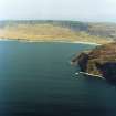
General oblique aerial view looking across Laig Bay towards Cleadale and the north side of Eigg, taken from the SW.
RCAHMS Aerial Photography
10/4/2003
© Crown Copyright: HES

SC 1699492
General oblique aerial view looking across Laig Bay, with the fort in the foreground, towards Cleadale and the north side of Eigg, taken from the WNW.
RCAHMS Aerial Photography
10/4/2003
© Crown Copyright: HES

SC 2563798
Elevated view from SSE
Records of the Royal Commission on the Ancient and Historical Monuments of Scotland (RCAHMS), Edinbu
5/8/1999
© Crown Copyright: HES

SC 2563800
Elevated view from SE
Records of the Royal Commission on the Ancient and Historical Monuments of Scotland (RCAHMS), Edinbu
5/8/1999
© Crown Copyright: HES

SC 2563811
General view from NE
Records of the Royal Commission on the Ancient and Historical Monuments of Scotland (RCAHMS), Edinbu
5/8/1999
© Crown Copyright: HES

SC 2563818
General view towards Howlin from WNW
Records of the Royal Commission on the Ancient and Historical Monuments of Scotland (RCAHMS), Edinbu
5/8/1999
© Crown Copyright: HES

SC 743147
General view of Cleadale houses, Eigg
Papers of Erskine Beveridge, antiquarian, Dunfermline, Fife, Scotland
25/9/1883
© Courtesy of HES (Erskine Beveridge Collection)

SC 875520
Elevated view from SSE
Records of the Royal Commission on the Ancient and Historical Monuments of Scotland (RCAHMS), Edinbu
5/8/1999
© Crown Copyright: HES

SC 875762
General oblique aerial view looking across Laig Bay, with the fort in the foreground, towards Cleadale and the north side of Eigg, taken from the WNW.
RCAHMS Aerial Photography
10/4/2003
© Crown Copyright: HES

SC 1551746
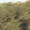
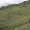
Eigg, Cleadale. View of lazy beds at Cleadale.
Records of the Royal Commission on the Ancient and Historical Monuments of Scotland (RCAHMS), Edinbu
2001
© Crown Copyright: HES

SC 1551825
Eigg, Cleadale, Township. View of township from E.
Records of the Royal Commission on the Ancient and Historical Monuments of Scotland (RCAHMS), Edinbu
6/2001
© Crown Copyright: HES

SC 1556069
Oblique aerial view of the crofting township and field-system, taken from the WNW.
RCAHMS Aerial Photography
10/4/2003
© Crown Copyright: HES

SC 1574448
Copy of a historic photographic view of Cleadale township, from the Banff Album.
General Collection. Photograph Albums.
7/1913
© RCAHMS

SC 1699341
General oblique aerial view of Cleadale and the north end of Eigg, taken from the S.
RCAHMS Aerial Photography
10/4/2003
© Crown Copyright: HES

SC 2249572
Eigg, Cleadale, Township. View of Cleadale from Poll Duchaill.
Records of the Royal Commission on the Ancient and Historical Monuments of Scotland (RCAHMS), Edinbu
2001
© Crown Copyright: HES

SC 2563742
Copy of a historic photographic view of Cleadale township from the Banff Album.
General Collection. Photograph Albums.
7/1913

SC 2563812
General view from NE
Records of the Royal Commission on the Ancient and Historical Monuments of Scotland (RCAHMS), Edinbu
5/8/1999
© Crown Copyright: HES

SC 2563813
General view from NNE
Records of the Royal Commission on the Ancient and Historical Monuments of Scotland (RCAHMS), Edinbu
5/8/1999
© Crown Copyright: HES

SC 2563819
View towards Howlin from WNW
Records of the Royal Commission on the Ancient and Historical Monuments of Scotland (RCAHMS), Edinbu
5/8/1999
© Crown Copyright: HES

SC 1398962
General view from ESE
Records of the Royal Commission on the Ancient and Historical Monuments of Scotland (RCAHMS), Edinbu
5/8/1999
© Crown Copyright: HES

SC 1544595
Eigg, Cleadale, Township. View of Cleadale from Poll Duchaill.
Records of the Royal Commission on the Ancient and Historical Monuments of Scotland (RCAHMS), Edinbu
2001
© Crown Copyright: HES

SC 1551745
Eigg, Cleadale. General view from N.
Records of the Royal Commission on the Ancient and Historical Monuments of Scotland (RCAHMS), Edinbu
2001
© Crown Copyright: HES

SC 1556070
Oblique aerial view centred on the church, crofting township and field-system, taken from the SW.
RCAHMS Aerial Photography
10/4/2003
© Crown Copyright: HES

SC 1556074
General oblique aerial view centred on the Bay of Laig with the crofting township beyond and the remains of the fort adjacent, taken from the W.
RCAHMS Aerial Photography
10/4/2003
© Crown Copyright: HES

SC 1556075
General oblique aerial view centred on the Bay of Laig with the crofting township beyond and the remains of the fort adjacent, taken from the W.
RCAHMS Aerial Photography
10/4/2003
© Crown Copyright: HES

DP 302498
General view SW over Cleadale towards Laig bay.
Papers of Dr George F Geddes, archaeologist, Edinburgh, Scotland
12/7/2019
© Copyright: G F Geddes. Courtesy of HES.

SC 2563804
View of specimen croft from NW
Records of the Royal Commission on the Ancient and Historical Monuments of Scotland (RCAHMS), Edinbu
5/8/1999
© Crown Copyright: HES

SC 2563814
General view from NNE
Records of the Royal Commission on the Ancient and Historical Monuments of Scotland (RCAHMS), Edinbu
5/8/1999
© Crown Copyright: HES

SC 1398958
View of township from NNE
Records of the Royal Commission on the Ancient and Historical Monuments of Scotland (RCAHMS), Edinbu
5/8/1999
© Crown Copyright: HES

SC 1399208
Elevated view from SE
Records of the Royal Commission on the Ancient and Historical Monuments of Scotland (RCAHMS), Edinbu
5/8/1999
© Crown Copyright: HES

SC 1399211
View towards Howlin from WNW
Records of the Royal Commission on the Ancient and Historical Monuments of Scotland (RCAHMS), Edinbu
5/8/1999
© Crown Copyright: HES

SC 1551752
Eigg, Cleadale. General view of Cleadale from S.
Records of the Royal Commission on the Ancient and Historical Monuments of Scotland (RCAHMS), Edinbu
2002
© Crown Copyright: HES

SC 1556063
Oblique aerial view of the crofting township and field-system, taken from the ENE.
RCAHMS Aerial Photography
10/4/2003
© Crown Copyright: HES

SC 1699305
Oblique aerial view of the crofting township and field-system with farmstead adjacent taken from the WSW.
RCAHMS Aerial Photography
10/4/2003
© Crown Copyright: HES

SC 1699316
General oblique aerial view centred on the Bay of Laig with the crofting township beyond and the remains of the fort adjacent, taken from the W.
RCAHMS Aerial Photography
10/4/2003
© Crown Copyright: HES

SC 2563806
View of township from NNE
Records of the Royal Commission on the Ancient and Historical Monuments of Scotland (RCAHMS), Edinbu
5/8/1999
© Crown Copyright: HES
- Council Highland
- Parish Small Isles
- Former Region Highland
- Former District Lochaber
- Former County Inverness-shire
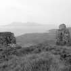
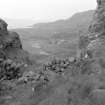
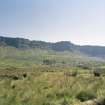
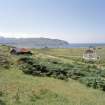
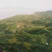
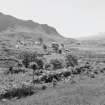
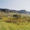
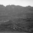
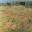
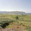
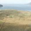
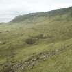
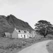
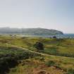
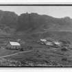
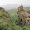
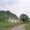
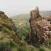
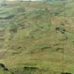
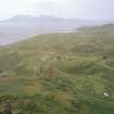
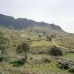
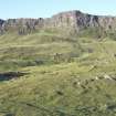
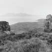
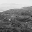
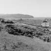
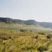
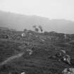
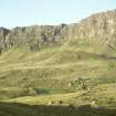
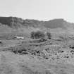
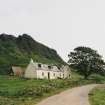
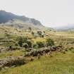
Cleadale Crofting hamlet beneath the fretted heights of Sgorr an Fharaidh, one of the island's three townships in 1806 and the first to be divided up (in 1810) into small enclosed lots as an incentive for those whose labours were essential to the profitable business of harvesting kelp. Only Croft No 6 retains its traditional roundcornered 19th-century dwelling, modernised early 20th century when most thatched roofs on the island were replaced with red tin. In 1913 , five identical improved houses were built at the new township of Cuagach for crofters removed from Galmisdale. Each had a slate roof, cast-iron range, panelling and two upstairs bedrooms (the old houses became their byres).
Taken from "Western Seaboard: An Illustrated Architectural Guide", by Mary Miers, 2008. Published by the Rutland Press http://www.rias.org.uk

NM48NE 31.00 centred on 477 888
NM48NE 31.01 NM 4775 8854 Farm
NM48NE 31.02 NM 4780 8880 Farm
NM48NE 31.03 NM 4780 8913 Longhouse
NM48NE 31.04 NM 47811 88794 Croft House (HBM Listed)
NM48NE 31.05 NM 4781 8897 House
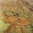
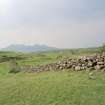
A crofting township, comprising sixty roofed buildings, one partially roofed building and seven unroofed buildings is depicted on the 1st edition of the OS 6-inch map (Argyllshire & Inverness-shire, Islands of Rum & Eigg 1879, sheet lxxi). Sixteen roofed buildings, one partially roofed building and thirteen unroofed buildings are shown on the current edition of the OS 1:10000 map (1976).
Information from RCAHMS (AKK) 9 December 1996.

