
Following the launch of trove.scot in February 2025 we are now planning the retiral of some of our webservices. Canmore will be switched off on 24th June 2025. Information about the closure can be found on the HES website: Retiral of HES web services | Historic Environment Scotland
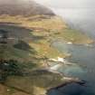
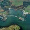
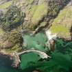
Eigg, Clanranald Harbour


Harbour (18th Century), Slipway(S) (20th Century)
Site Name Eigg, Clanranald Harbour
Classification Harbour (18th Century), Slipway(S) (20th Century)
Canmore ID 106132
Site Number NM48SE 26
NGR NM 48319 84137
Datum OSGB36 - NGR
Permalink http://canmore.org.uk/site/106132


- Council Highland
- Parish Small Isles
- Former Region Highland
- Former District Lochaber
- Former County Inverness-shire
Measured Survey (24 April 2002 - 25 April 2002)
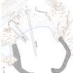
RCAHMS surveyed the Clanranald Harbour between 24-25 April 2002 with plane-table and self-reducing alidade at a scale of 1:500. The plan was later used as the basis for an illustration that was published in 2016 (Hunter, fig. 3.51).
Field Visit (12 October 2002)
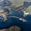
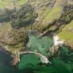
This harbour, which dries out at low tide, stands at the head of Galmisdale Bay. It comprises two piers, each partly founded on a low reef, which curve towards each other to enclose an area measuring about 50m from N to S by 45m. The harbour mouth, which is on the S, is about 17m wide. The E pier is the better-preserved of the two, measuring about 45m in length by 4.4m in breadth and standing up to 3m in height at its S end, where a flight of steps leads down towards the water. The W pier, by contrast, appears as little more than an elongated pile of rubble.
There are two slipways within the harbour. One, at least 50m long, carries a pair of iron rails; the other is made of concrete and is used to overwinter a yacht.
This harbour, known as the Clanranald Pier, was built in 1790. The E pier is shown on William Bald's 1806 map of Eigg; the W pier was added by 1877, the date of the 1st edition of the OS 6-inch map (Island of Eigg, Inverness-shire sheet lxxiii).
(EIGG01 1193)
Visited by RCAHMS (AGCH) 12 October 2002
C Dressler 1998

