|
Manuscripts |
MS 329 |
|
Dunkeld Cathedral.
Index of Early Chapel and Church Sites no. 42 |
c. 1970 |
Item Level |
|
|
Photographs and Off-line Digital Images |
G 98214 PO |
Central Excavation Unit |
Oblique aerial view centred on the remains of the chapel and burial ground, with the remains of enclosures adjacent, taken from the NE. |
1980 |
Item Level |
|
 |
On-line Digital Images |
DP 137987 |
RCAHMS Field Survey Digital Photography |
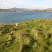
General shot of the chapel, taken from the SW. |
22/6/2012 |
Item Level |
|
 |
On-line Digital Images |
DP 137996 |
RCAHMS Field Survey Digital Photography |
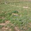
View of well head, taken from the NE. |
22/6/2012 |
Item Level |
|
 |
On-line Digital Images |
SC 2357748 |
Records of the Ordnance Survey, Southampton, Hampshire, England |
Killegray, Teampull Na H' Annait, NF98SE 1, Ordnance Survey index card, page number 2, Verso |
c. 1958 |
Item Level |
|
 |
On-line Digital Images |
SC 2357749 |
Records of the Ordnance Survey, Southampton, Hampshire, England |
Killegray, Teampull Na H' Annait, NF98SE 1, Ordnance Survey index card, page number 1, Recto |
c. 1958 |
Item Level |
|
 |
On-line Digital Images |
SC 2357750 |
Records of the Ordnance Survey, Southampton, Hampshire, England |
Killegray, Teampull Na H' Annait, NF98SE 1, Ordnance Survey index card, page number 2, Verso |
c. 1958 |
Item Level |
|
 |
On-line Digital Images |
SC 2357751 |
Records of the Ordnance Survey, Southampton, Hampshire, England |
Killegray, Teampull Na H' Annait, NF98SE 1, Ordnance Survey index card, Recto |
c. 1958 |
Item Level |
|
 |
On-line Digital Images |
SC 2357752 |
Records of the Ordnance Survey, Southampton, Hampshire, England |
Killegray, Teampull Na H' Annait, NF98SE 1, Ordnance Survey index card, Recto |
c. 1958 |
Item Level |
|
|
All Other |
MS 2321/05 |
Historic Scotland Archive Project |
Excavation archive: Reports, sketches and correspondance relating to James McEwen's 1963-4 excavations at Northton and survey on Killegray (in 1966). |
1963 |
Batch Level |
|
|
All Other |
551 166/1/1 |
Records of the Ordnance Survey, Southampton, Hampshire, England |
Archaeological site card index ('495' cards) |
1947 |
Sub-Group Level |
|


