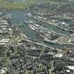
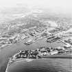
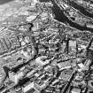
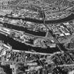
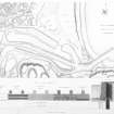
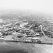
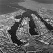
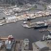
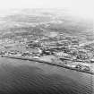
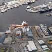
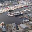
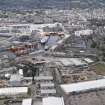
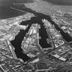
Accessibility

Font Size

100% 150% 200%

Background Colour

Default Contrast
Close Reset

Aberdeen Harbour

Harbour (Period Unassigned)

Site Name Aberdeen Harbour

Classification Harbour (Period Unassigned)

Canmore ID 104076

Site Number NJ90NW 291

NGR NJ 9400 0500

NGR Description Centred NJ 9400 0500

Datum OSGB36 - NGR

Permalink http://canmore.org.uk/site/104076

Ordnance Survey licence number AC0000807262. All rights reserved.
Canmore Disclaimer. © Bluesky International Limited 2025. Public Sector Viewing Terms

Toggle Aerial | View on large map

Digital Images

Aberdeen harbour, oblique aerial view.
Aberdeen harbour, oblique aerial view.Aberdeen. 
General oblique aerial view centred on the harbour, taken from the NW.Oblique aerial view of Aberdeen Harbour, looking to the WSW.Oblique aerial view of Aberdeen Harbour with the Victoria Bridge beyond, looking to the SW.General oblique aerial view of Aberdeen, looking to the SW.Aberdeen Harbour, oblique aerial view, taken from the NNW.Aberdeen City Centre, oblique aerial view, taken from the NNW, centred on Marischal College.Oblique aerial view of Aberdeen Harbour with the Victoria Bridge beyond, looking to the W.Aberdeen Harbour, oblique aerial view, taken from the NW.Aberdeen Harbour, oblique aerial view, taken from the NNW. The E end of Union Street is visible in the foreground.Engraving of elevation and plan inscr: ''Plan of the harbour and part of the City of Aberdeen. Includes plan of new wharfs.''Aberdeen Harbour, oblique aerial view, taken from the NW.Aberdeen Harbour, oblique aerial view, taken from the W.Oblique aerial view of Aberdeen Harbour with the Victoria Bridge beyond, looking to the SSW.Aberdeen Harbour, oblique aerial view, taken from the N.Oblique aerial view of Aberdeen Harbour, looking to the SW.Oblique aerial view of Aberdeen Harbour with the Victoria Bridge beyond, looking to the WSW.Oblique aerial view of Aberdeen Harbour, looking to the SW.CAM oblique no. AF855, 9 May 1942. View of Aberdeen with docks in foreground with anti-invasion defences in place.Oblique aerial view centred on Aberdeen Harbour and the River Dee, looking to the WNW.Aberdeen harbour, oblique aerial view.Aberdeen City Centre, oblique aerial view, taken from the NW, centred on Marischal College.Aberdeen Harbour, oblique aerial view, taken from the W.Oblique aerial view of Aberdeen Harbour, looking to the SW.Aberdeen City Centre, oblique aerial view, taken from the NW, centred on St Nicholas' Church, Union Street.

Administrative Areas

  • Council Aberdeen, City Of
  • Parish Aberdeen
  • Former Region Grampian
  • Former District City Of Aberdeen
  • Former County Aberdeenshire

Archaeology Notes

NJ90NW 291.00 centred 9400 0500

Continued from map sheet NJ90NE: for general account, see NJ90NE 7.00.

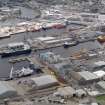
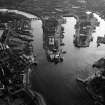
NJ90NW 291.01 9489 0574, 9450 0583 to 9529 0567 Albert Basin

NJ90NW 291.02 centred 9485 0573 Albert Basin, Pontoon Docks

NJ90NW 291.03 9466 0521 to 9499 0530 Albert Basin, Fish Market

NJ90NW 291.04 9457 0584 to 9529 0571 Albert Basin, Commercial Quay

NJ90NW 291.05 9459 0573 to 9553 0559 Albert Basin, Albert Quay

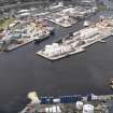
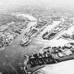
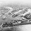
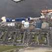
NJ90NW 291.06 centred 9490 0605 Victoria Dock

NJ90NW 291.07 9460 0611 to 9479 0612 Victoria Dock, Regent Quay

NJ90NW 291.08 9468 0616, 9460 0615 to 9476 0617 Victoria Dock, Regent Quay, Regent Shed

NJ90NW 291.09 9452 0602 Victoria Dock, Ferry Terminal

NJ90NW 291.10 9498 0607, 9480 0616 to 9517 0600 Victoria Dock, Waterloo Quay

NJ90NW 291.11 9462 0604 to 9531 0582 Victoria Dock, Blaikie's Quay

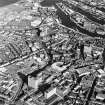
NJ90NW 291.12 9445 0604, 9434 0605 to 9457 0609 Upper Dock (Trinity Quay)

NJ90NW 291.13 9458 0608, 9458 0611 to 9458 0605 Regent Bridge

NJ90NW 291.14 94445 06165 15-16 Regent Quay, Harbour Offices

For remains of harbour discovered in excavation at Shore Brae (NJ 9437 0612), see NJ90NW 81.

For Trinity Quay, Weigh-house (NJ 9444 0617), see NJ90NW 264.

References

MyCanmore Image Contributions


Contribute an Image

MyCanmore Text Contributions