Pricing Change
New pricing for orders of material from this site will come into place shortly. Charges for supply of digital images, digitisation on demand, prints and licensing will be altered.
Upcoming Maintenance
Please be advised that this website will undergo scheduled maintenance on the following dates:
Thursday, 9 January: 11:00 AM - 3:00 PM
Thursday, 23 January: 11:00 AM - 3:00 PM
Thursday, 30 January: 11:00 AM - 3:00 PM
During these times, some functionality such as image purchasing may be temporarily unavailable. We apologise for any inconvenience this may cause.
Field Visit
Date 6 May 1954
Event ID 925525
Category Recording
Type Field Visit
Permalink http://canmore.org.uk/event/925525
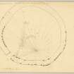
Defensive Enclosure, East Rowanhill
This structure is situated on low-lying land a quarter of a mile SE of East Rowantreehill farmhouse at a height of 300 feet O. D. To E, S and W the approaches are level, but immediately N of the site the ground rises 100 feet in a distance 350 feet. The structure is almost circular on plan, measuring about 85 feet in diameter with a rubble-cored stone wall 7 feet 6 inches thick. Numerous facing stones remain in situ on either side of the E, N and W arcs, some of them measuring as much as 4 feet in length and standing up to 3 feet 6 inches above ground. The entrance, 7 feet in width lies in the arc, and immediately inside it is a level area 60 feet in length aligned from NNE to SSW and bounded on the E by the enclosure wall and on the W by a low rocky scarp. A few feet W of this there is a crescentic scarp 17 feet in length. The rest of the interior is rocky, uneven and featureless.
The situation suggests that the structure cannot be a fort, as indicated on one Ordnance Survey Map (1 inch Sheet 72) while its character is not that of an earthwork, as it is defined on another (6 inch Sheet vii). It is comparable in appearance to the structures on Hownam Law and at Buchtrig, in Roxburghshire (Inventory Nos. 326 and 328), and may have served an agricultural purpose in mediaeval times.
NS 369 689
OS Map vii NW (Earthwork)
Visited by RCAHMS (RWF) 6 May 1954


