Field Visit


Date 19 May 2009
Event ID 581546
Category Recording
Type Field Visit
Permalink http://canmore.org.uk/event/581546
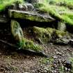
This chapel and the graveyard in which it stands are situated on a low, natural knoll on the leading edge of a W-facing terrace 270m SW of Kilmichael farmsteading. The E flank of the knoll slopes gently onto the flat of the terrace, but the W flank falls onto the steep face of the terrace, and here the graveyard wall, which elsewhere follows the foot of the knoll, takes the form of a revetment 1.2m in height. The ruinous chapel is as previously described. A cist (NS 99242 70557) is visible on the S side of the graveyard, where a section of the wall has collapsed and the knoll is badly eroded. Orientated NE and SW, it measures at least 1.6m in length by 0.9m in width and 0.45m in height within a capstone and side-slabs.
A low rubble mound, which may be a tinker's grave (J Herriot pers. comm.), is situated by the entrance in the N side of the chapel. The chapel, which is depicted on Mackinlay's map of 1823, is shown unroofed on the 1st edition of the OS 6-inch map (Argyllshire and Buteshire 1869, Sheet CXCIII).
Visited by RCAHMS (GFG, PM) 19 May 2009.